Inside METARS and TAFs
METARs and TAFs have long been the mainstays of aviation weather. Youve probably got a handy decoding guide on your desk or bookmarked in your web browser, so we wont focus on that. However well fill you in with background information-ranging from trivia to amuse other pilots on a long haul, to important tidbits that will provide insight and some options in rough weather.
Useful Model Fields for Pilots
10 m wind corresponds exactly to the wind as would be observed. The model data also offers gust strength and maximum wind for the hour.
Weather Modeling
In Wx Smarts we focus on outsmarting the weather through heightened weather-situational awareness. Yet, in my three years here, I havent discussed forecast models. Its time.Models dont yet belong in the cockpit, but they can be valuable for planning and understanding whats going through the minds of the forecasters. Plus, models are useful for long-range outlooks.
Southeast Summer
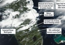
If you think summer weather in the southeastern states means sunshine and VFR, you probably havent experienced one of the numerous warm-season ground stops on traffic going to Atlanta. Granted this part of the country gets plenty of blue sky, but its also when the region gets the bulk of its precipitation. Furthermore some readers might have noticed weather charts almost never show fronts in this area during the summer. So how can we truly get a handle on what to expect?Most of the time when youre dealing with preflight weather briefings and TAFs, you only see half the picture: the final forecast. Very few pilots actually get to see the thinking that goes into the predictions. Its my job to give you that.
RVR is not Visibility
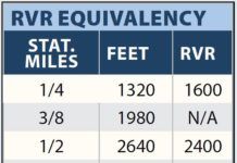
The FAA helps us confuse runway visual range (RVR) with flight visibility, but theyre different concepts. RVR is an instrumentally-derived value at a runway. Flight visibility is a pilot-observed distance in flight. Regulation 91.175 is clear-flight visibility is required to descend below DA/MDA. Yet, approach charts confusingly equate the two by providing both RVR and visibility values.
Readback: July 2015
Last fall as I was departing Reno, NV (KRNO), the weather was 1500 overcast (6000 MSL), tops 10,000 MSL, surface temp +10 C and there was no precipitation. I was flying my pressurized, turbocharged, FIKI-certified Cessna 414. Id flight planned for FL 190. I hand flew the departure because that is recommended when potential icing conditions exist. In the climb I noticed light rime ice on the leading edges of the wings. I was watching carefully for decreasing performance (airspeed, rate of climb, etc.) and all seemed quite normal.
Summer Patterns
For many pilots, summer means fly-ins, more flying and searches for the best $100 hamburger. It also marks the end of powerful jet streams and large, organized weather systems that cross the United States from one end to the other. By the time June rolls around, all that stuff shifts north and becomes a problem for our Canadian friends. But, that also gives them four months of mild summer temperatures, so dont feel too bad for them.So what exactly do we have in the United States? We can distill it down to three main features. First theres the large Atlantic Bermuda high, covering the eastern half of the country. Second is the cool Pacific high, which maintains a tenacious foothold on the West Coast. Finally theres the broad thermal low located between the Sierra Nevadas and Rocky Mountains, strongest by far over Arizona. Its driven mostly by intense solar heating.
Stay Out of The Dirt
With the exception of a crazed pilot bent on suicide and/or mass murder, nobody wants their airplane to hit the ground at speed. Why, then, do we continue to pilot our aircraft under control all the way to the point of impact with Mother Earth? Pros and students alike are guilty, and perhaps the most frustrating aspect of this is that these oft-fatal accidents are all preventable.The answer begins with proper pre-flight planning to evaluate the risks and your performance. The rest is having the discipline to follow through. This may all seem obvious, but we keep crashing, so lets see what we can do about it.
Spring Patterns
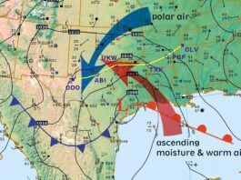
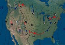
Aviation weather columns typically talk about hazards in terms of elements: Watch the 0 to -20 degrees C layer for icing. Be cautious of wet, clear nights because of fog, etc. We can always learn more from a change in perspective, and we can do so using surface charts from the Aviation Weather Center website. Using these charts we can get a better understanding of why weather hazards occur rather than how they develop. Lets take a look at the sample chart below and break down all the patterns that are going on.
Do You Know Ice?
Februarys Cowboy and Cowards sparked some passionate responses about known icing and my assertion that known icing is observed icing. To better understand known icing, we need to look at the concept from definitional, legal, and safety perspectives.
What the Heck Makes Thundersnow?
The phenomena can happen in any snowstorm where the conditions happen to be ripe for lightning formation. It turns out that lake (or ocean)...
Snowflakes and Lightning
Every now and then someone asks, Whats your favorite airplane? Before one stormy January evening, that was a tough call for someone with 47 years and 12,000 hours of flying. After that evening, one particular turboprop twin always takes first prize.
