
Summertime almost certainly means vacations, cookouts, and maybe some time on the beach. There are airshows, fly-ins, $100 hamburgers, and of course AirVenture at the end of July. Whatever the destination, there’s a good chance you’ll be putting in some flight hours in the coming months.
Flying outside your home area means unknown weather patterns that work differently from what you are accustomed. You can increase your safety margins by understanding how the weather varies between parts of the country and the kinds of common patterns. We’ll start with a top-down picture and then break things into regions.
The Big Picture
The most powerful factor that drives pattern changes across North America during the summertime is the northward shift in the latitude band where the sun is highest in the sky. This band crosses the equator during the spring equinox and reaches 23.4 degrees north, the Tropic of Cancer, during the summer solstice in late June, then slowly moves south again. There isn’t an instantaneous band of hot temperatures directly underneath the sun. Rather, the atmosphere lags solar heating by about a month.
The band of maximum heating correlates with a maximum in convective-driven cloud systems, forming a zone known as the Intertropical Convergence Zone (ITCZ). This is not a single feature that we can easily identify on surface charts. Still, comparing latitudes further north or south, we find many more showers and thunderstorms within this band than elsewhere.
Although the ITCZ follows the sun, it’s not something we have to contend with in the United States. The ITCZ remains mostly confined to Central America and the southern Caribbean.
However, the sun creates strong heating on the North American continent, generating vast amounts of rising motion and low pressure. This produces a thermal circulation in which air aloft moves out over the oceans, having a mass surplus that creates vast high-pressure systems over the North Atlantic and North Pacific. If an island existed halfway between Hawaii and Alaska and if you flew there in July, it would be common to have to set your altimeter to 30.60 inches when arriving.
Likewise, low pressure is expected in the continental regions where intense heating has been at work. Although atmospheric pressure doesn’t bottom out at the 28.50-inch readings we often see with potent winter snowstorms, it frequently falls to the 29.50-inch range in places like Colorado, western Nebraska, and Arizona. This can have a major impact on density altitudes, especially in the higher elevations.
Southwest Deserts
The weather in the southwest deserts is hot. May and June tend to be clear, with hot days and warm nights. This part of summer offers the best opportunities for VFR flight, though it will be unpleasant on the ramp and bumpy in the air.
Due to the intense heating, a semipermanent heat low develops. This is normally found in western Arizona, but it may shift into the Mojave Desert, the San Joaquin Valley, or into southern Nevada.
Deep moisture from the tropical latitudes begins entering the picture once we get into July. This moisture originates from a couple of sources: the Gulf of California and the Gulf of Mexico. Here, sea surface temperatures gradually climb into the 80s during the summer, resulting in massive evaporation. Due to the Southwest’s heat low and the depressed pressures in the North American continent, this air gradually infiltrates northern Mexico. This surge of moisture is known as the Southwest Monsoon.
By early July, this humid air is found in New Mexico. Late in the month, it builds into eastern Arizona and southern Colorado. During August, it reaches the remainder of Arizona and the deserts of California, Nevada, and Utah. This arrival time isn’t scheduled with a calendar, but depends on the patterns, and Arizona residents endure the endless speculation on when the monsoon will begin.
When it happens, dewpoints increase from the 30s to the 50s or higher. There’s also a sharp increase in afternoon and evening thunderstorm activity. Due to the vast amounts of dry air in the upper levels, these storms pose significant risks for microbursts and can produce extensive dust storms in places like Phoenix. They also yield dangerous lightning storms. Thankfully, hail and tornadoes are rare.
The monsoon conditions slowly wind down in September and are replaced by autumn weather patterns.
West Coast
Weather on the West Coast is dominated by the pressure gradient between the Pacific Ocean and the interior regions, where we find the southwest heat low. This brings oceanic air inland in the form of a marine layer that is just cold, humid, and breezy, but other times produces stratus layers and fog.
These intrusions of fog and stratus are most likely to occur at night, especially in northern California, Oregon, and Washington. Because of the thermal circulation, they’re often correlated with heatwaves in the interior regions. So, if you hear about record heat at places like Sacramento, Klamath Falls, and Spokane, expect low ceilings along the coast and in straits and coastal mountain passes. This stratus rarely reaches more than 100 miles inland and dissipates from east to west with morning and afternoon heating.
In California’s San Joaquin Valley, most of the summer is dominated by the southwest heat low. The Southwest Monsoon does not reach this region, so dry VMC prevails. However, moisture occasionally makes it to the Sierra Nevada mountains, producing high-based thunderstorms late in the afternoon.
Rockies
If hiking, fishing, or hunting are your thing, chances are your flying activities bring you to the Rocky Mountains. While we often think of it as a region of 14,000-foot mountains, it’s better to contemplate this area in terms of the elevation of the valley floors: almost entirely between four and seven thousand feet MSL in most of Utah, western Colorado, Wyoming, and Idaho. This makes the region a vast plateau, outlined by numerous mountain ranges.
During May, the Rockies are dry, but affected by numerous weather systems sweeping eastward from the Pacific. These systems encourage afternoon thunderstorm activity over the mountains. June is often dry, but July brings the arrival of the Southwest Monsoon, initially in New Mexico but spreading north into Colorado in July and even Utah, Idaho, and Wyoming by August.
This brings afternoon thunderstorms that start over the mountains and move into the valleys. Depending on the vegetation moisture, some of these storms may start wildfires. When that happens, visibility obscuration from smoke and haze can be a problem.
When afternoon heating takes temperatures into the 80s and 90s, be vigilant about weight and density altitude. Elevation, temperature, and low pressure all conspire to provide the bare minimum of lift, producing long takeoff runs and poor climb performance.
Great Plains
The central states are heavily influenced by moisture from the Gulf of Mexico. This produces severe weather during the spring in the southern Plains. June and July are often active with thunderstorms in Kansas and Nebraska. All these storms can produce significant tornadoes, gargantuan hail, and tops of over 70,000 feet.
The two biggest hailstones (almost two pounds) ever to fall in the United States occurred in Nebraska and South Dakota in mid-summer. Large tornadoes are also common in Nebraska and Iowa in June and the Dakotas in July. It’s not smooth sailing following spring on the Great Plains.
Most of these storms are generated along fronts and drylines, and especially near their intersections. These fronts are usually oriented northeast to southwest through the Dakotas, Nebraska, or Kansas, resulting from stalled Canadian fronts. The dryline usually rests somewhere from Rapid City, South Dakota, to southeast Colorado. When these boundaries oscillate westward, we find hailstorms and landspouts (tornadoes formed from the ground up towards the base of a cloud) in the Denver and Cheyenne areas. At other times, the boundaries drift east, bringing hail and tornadoes to places like Sioux Falls, Omaha, and Kansas City.
An essential aspect of these storms is their tendency for upscale development during the nighttime due to the extensive Gulf moisture supply. This results in a storm complex known as an MCS (mesoscale convective system). During the summer, these MCS events often occur nightly in Kansas, Nebraska, the Dakotas, Iowa, and Minnesota. They produce lots of beneficial rain for the Corn Belt. When planning a cross-country flight, the safest time to cross this region is the late morning hours.
Further south in Oklahoma and Texas, the weather is typically VMC with scant precipitation. Storms often develop in west Texas and the Panhandles that move little and end after dark. Widespread rains only come later in August as deep tropical easterly flow sets in. This pattern produces the type of storms that downed Delta Flight 191 at DFW Airport in 1985.
Southeast Region
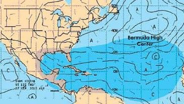
The development of extensive oceanic highs also happens in the Atlantic, producing a semi-permanent high often found between the Azores and Bermuda, known as the Bermuda High. The weather in the southeast United States is shaped by the interaction of the cool Bermuda High with the warm areas of depressed pressures in the interior regions. This produces a prevailing wind blowing out of the east in Florida and a south or southeast wind that blows throughout the southeastern states.
There is plenty of moisture available, so afternoon thunderstorms are frequent, and they develop wherever a boundary can be found. Sometimes
a strong front from the Great Lakes region reaches the
southeastern states and stalls. This can produce multiple days of thunderstorm activity. These thunderstorms form new boundaries that shape weather on the following day. So, there’s no way to predict where storms will form more than a day in advance; we only have a sense of heightened or diminished storm potential. Sea breezes and land breezes are extremely important in coastal regions. During the morning, the sea breeze drives inland, becoming an essential source for thunderstorm development in Florida and areas stretching from Houston to New Orleans to Savannah.
These sea breezes will sometimes move inland as far as 150 miles by early evening, where they begin dissipating.
Likewise, a land breeze develops at night. Offshore thunderstorms late at night sometimes occur due to the convergence along this boundary, and a common location for this is in the waters south of the western Florida coast.
It’s important to mention the reversal of upper-level flow that often comes in late summer. When this happens, winds in the upper levels, roughly above 10,000 feet MSL, become easterly, producing a deep easterly flow throughout the troposphere.
These easterlies occur when the large belt of subtropical high in the upper levels shifts northward to roughly 35-40 degrees north, producing hot weather and drought conditions in places like Kansas and Illinois. But along the Gulf Coast, easterly tropical flow is in place. The sky takes on an appearance of great depth, and tall cumulonimbus clouds easily reach 50,000 feet.
Easterly waves, westward-moving disturbances in the flow between the subtropical high and the ITCZ, occasionally graze coastal regions, producing bands of westward-moving showers and storms that reach as far west as Dallas and Austin. Hurricanes, tropical storms, and tropical depressions
are more common. This tropical phase comes to an end by mid-September as the subtropical ridge shifts back south
in response to gradual cooling.
Northeast and Great Lakes
During the summer, fronts and jet streams shift northward into the border states and Canada. The fronts continue to have a major impact on weather in the Midwest, the Great Lakes, and the northeast states. Here we find cold front passage and cool northwest winds alternating with warm front passage and hot, humid southwest winds.
After the cold front passes, we either see high pressure moving through the region, producing clear blue skies and mild weather, or we find the cold front stalling out, forming an east-west or northeast-southwest boundary. When this happens, cloudy weather and multiple days of showers and thunderstorms are likely.
Weather is overwhelmingly dominated by this progression of air masses and fronts. So, when you fly this region, look not only at the TAF but also the surface progs on the Aviation Center website under Forecasts > Prog Charts, Click on the “Sfc” button at the top, and use the time controls to see forecast charts.
Keep It Simple
If you’re not sure what’s going on, return to the basics. Summer means cold oceans and high pressure and warm land masses with low pressure. Be aware of the march of cold fronts and the advance of moisture moving in from tropical regions. And finally, don’t forget the effect of the land-sea breeze and mountain-valley winds. All of this is found in more detail in FAA AC 00-6B, Aviation Weather.


