
It’s a cloudy, breezy day, and you’re flying the family from northern Iowa to Chanute in southeastern Kansas. Other than a headwind and a Convective SIGMET covering part of the way, there’s no significant weather occurring, and the forecast is steady. So the concern at hand is the approach: Which one? There are two choices, but…
Prep The PT
Chanute might not be a choice destination, but the family gathering comes with free transportation and lodging. You’re planning Runway 18 for the forecast southwest wind at 15 knots. But, there’s no straight in for Runway 18. Both approaches have circling mins (1480-1) for your 95-knot Category B single.
Naturally, you’d prefer the RNAV 36, but you keep the VOR-A in mind just in case. The 800-foot ceiling is well above minimums, so you file for Chanute using nearby Joplin, Missouri’s ILS Runway 18 and a rental car as a solid plan B.
The circle-to-land will be the same with either procedure, although the similarities end there. Options for entering the VORA are vectors to final (preferred), or cross the CNU VOR/DME initialfinal fix and fly the course reversal. Overfly the CNU navaid at or above 2800 feet and time
the outbound leg on the 239-degree radial.
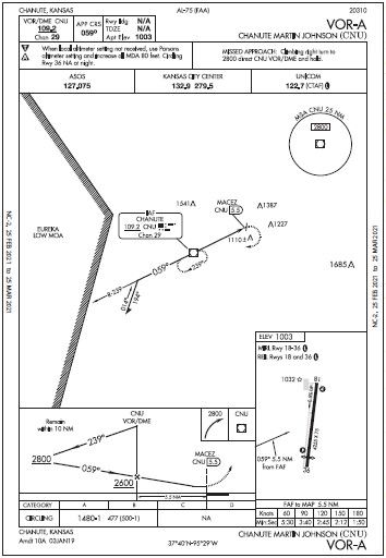
As the IAF is 5.5 NM from the runway, the nowind default outbound is one minute; today, make it two minutes. Why? As noted on the profile view, there’s a typical 10- mile limit for the procedure turn. For light aircraft, it’s rare to push up against that limit, especially with a headwind, so plan to give yourself enough room outbound to prepare for the tailwind inbound.
Groundspeed will start at about 100 knots (120 KIAS this early on approach, less a stronger 20-knot headwind at altitude). Two minutes will get you 3.3 NM from the VOR. Hopefully, you have a tablet GPS as a backup to check distance. If not, and you want some cushion, two and a half minutes will get you four miles out. Then start the course reversal.
The FAA approach chart shows, by convention, a 45-degree turn away from the inbound course, timing outbound for a minute (adjusted for wind). Again, go for extra time today into the wind— maybe one and a half minutes for about 2.5 NM. That ensures you’re ready for the wind to decrease the turn radius and increase your groundspeed, still within the 10-mile limit.
Next, fly a 180-degree turn to intercept final. Again, convention has you making the U-turn away from the airport, but if you have doubts about getting too far out, it’s okay to turn left again and intercept the final course.
Want a more wind-friendly or untimed course reversal? Barring any specific instructions, AIM 5-4-9 leaves it flexible: Use a teardrop, racetrack, or 80- 260 turns, provided they remain in the same piece of airspace. The 80-260 might be a good choice in the wind and needs no timing. From the outbound, turn to a heading of 160 degrees, followed by a right turn to pick up the inbound course of 059 degrees.
Descend to 2600 feet, cross the VOR again and start timing. The faster groundspeed (95 KIAS and still a bit stronger wind than at the surface, so perhaps 115 knots plus—fudge and use 120 on the table), means a bit over 2:45 to the runway. It’d be great to see the runway a little early—it’s a less abrupt transition to the circle. Overfly it about midfield for a left downwind to Runway 18.
If the time runs out and you don’t see anything, fly the missed starting with a climbing right turn. (Important note: This begins on the approach course of 059 degrees, not a runway heading). It’d be ideal at this point to be just over the runway, as the climbing right turn will avoid the two obstacles northeast of the field. It also has you circumnavigating the 1110-foot obstacle (give or take, see the chart) just south-southeast of the field. Remember that the turn radius will initially be wider in the tailwind, so get to 2800 feet as soon as practical and return to CNU for holding.
Get Your TPPs
With GPS, though, the RNAV 36 would be a lot easier. No messy procedure turn; just get cleared to CUMTA, then fly the intermediate and final legs. If the runway’s visible by the MAP/threshold, there’s ample time to sidestep for the left downwind to 18. Don’t even think about sidestepping too soon as it would get you near that 1110-foot ± obstruction. The missed also offers a lighter workload, with a brief straight-out climb to 2900 feet to IFAPY, then a 326-degree course to ERECI.
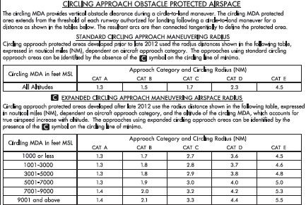
How much space around the runway do you have for circling? For guidance, you could find AIM 5-4-20 on Circling Approach areas. Better yet, have the Terminal Procedures Publication for Kansas/ Nebraska in your EFB. Both have the same circling radius tables, and the AIM also has a sketch of how the various circling radii are structured that’s more for home study.
The TPP, on the other hand, is good for both. It’s much easier to download and search than the AIM, which is unwieldy even in digital form. It also has essential in-flight information like airport diagrams and approach charts, takeoff/obstacle notes, etc. While you’re at it, you might grab the TPP for Missouri (your alternate), and Iowa.
Now, do you use the Standard or Expanded Circling criteria? The TPP explains the difference. Note that both IAPs at Chanute lack a on the circling minimums line, meaning the standard circling table applies. For comparison, your alternate approach at Joplin does have the indicating the larger circling areas. The Standard table for Category B is 1.5 NM. Either way, these center on the appropriate runway thresholds; if you fly a standard-width traffic pattern of about a mile, you will be well within the protected area.
Down To One
At cruise, your progress looks good for an on-time arrival—until that convective advisory you thought was a false alarm comes alive, increasing the headwind. You’re not quite halfway to Chanute. Just ahead is Kirksville, Missouri, with clear skies and a visible gap allowing you to divert there safely. After flying a perfect straight-in visual to Runway 18 and waiting an hour, the weather improves enough to continue.
But after another two hours en route, it’s 7:30 p.m. local. You’re still 20 minutes from Chanute, and the sun just set. Circling approaches in the dark are not your thing. Besides, night approaches NC-2, 25 FEB 2021 to 25 MAR 2021 NC-2, 25 FEB 2021 to 25 MAR 2021 are NA for the RNAV 36 and the VORA when circling to 36. So, Runway 18 is still available. Is there just enough time to use the RNAV since night starts at 8:06 p.m. local? (See “Not So Easy After All” in May.)
You decide to try one RNAV approach. If you miss, head for Joplin. It’s not quite dark when crossing the final fix and (thankfully) breaking out at 1800 feet. It’s now a more comfortable left downwind for Runway 18, circling above MDA while the obstacles are lit up and in sight.
Whether facing several choices or just one, having all the available tools helps assess the situation. Given that, you could’ve flown to a dozen other airports in the area. And even when a plan works out, it’s good to know those alternates were there all along.


