
These Sim Challenges have been accused of creating “gotchas” to catch the unsuspecting—and rightly so. That’s part of the game. So we decided it was only fair to spool up a bit different challenge. The gotchas here are largely ones in the venn diagram of conflict where good ol’ fashion procedure design meets 21st-century execution. We’ve added no traps.
Use any aircraft you like, but make sure it’s capable of climbing to at least 10,000 feet. It also must have an IFR GPS. If your sim doesn’t have one, fret not. You can “fly” this challenge in a manufacturer’s trainer app. Both Garmin and Avidyne make GPS trainers. There are special ATC instructions built into the scenario, so you’ll have to fly this one offline. Try it again on the PilotEdge network if you want to see how it plays out with “real” ATC.
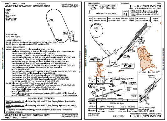
Leg 1: P52-KPRC
For the first leg, you’ll fly from Cottonwood, AZ (P52) to Prescott, AZ (KPRC). Set overcast clouds at 5200 MSL. That will correspond with the 200-foot ILS minimums at Prescott, and give you a little more breathing room for the departure at Cottonwood. Visibility should match the ½-mile minimum for the ILS 21L at Prescott. Set wind at the surface to 300 at 12 knots, increasing to 30 knots by 10,000 MSL.
Your route begins with a charted obstacle departure procedure: MINGY1.MINGY. From there you’ll head direct to CRADI, the IAF for the ILS 21L. The highest terrain within four miles on either side of the route is 8000 feet, so pick a cruise altitude of at least 10,000.
Wait to read the next instructions until the following points in the flight:
15 miles from CRADI: Phoenix Approach offers, “Maintain 10,000 until established, cleared straight-in ILS 21L.” That straight-in clearance allows you to skip the course reversal at CRADI. ATC can issue that because the course change is less than 90 degrees … barely. Cool.
5 miles from CRADI: ATC has had a change of heart, or maybe it’s just some conflicting traffic. The new instruction is “Cancel approach clearance. Hold at CRADI as published. Descend and maintain 9000. Expect further clearance 15 minutes from now.” Fly at least two laps of the hold before ATC clears you for the approach again. Land, clear the runway, and prepare for the next leg. First, answer these questions.
Departure
Would you have departed P52 at all in the real plane?
Ceilings are fine, but visibility is below standard takeoff minimums of 1 SM for aircraft having two or fewer engines. Of course, those minimums don’t apply to Part 91 operations, but if you had a problem after takeoff you wouldn’t be able to get back into Cottonwood.
How did you program the departure?
Just load it in the GPS and go, right? Not quite. Your GPS probably doesn’t include the hold at MINGY. If you have something like a GTN, you could build it manually in the flight plan. On others like the Garmin GNS series, you could use OBS mode to suspend sequencing and select the appropriate inbound course for the hold. Then you’d just need to unsuspend at the appropriate time upon reaching 10,000 to continue on course.
However, if you found MINGY on another chart, you might’ve determined that it was unlikely you’d need to hold. MINGY is 18 NM from the airport, enough time to climb to 10,000 in a plane with decent climb performance. (It requires a little more than 300 FPNM).
The ODP chart is misleading at first. The depiction for Runway 14 shows a nearly 180-degree left turn to arrive at MINGY northbound. In fact, it’s basically a straight-out departure to MINGY from that runway. See the “NOTE: Chart not to scale” hiding in the lower-right of the plan view.
Approach
How did you program the GPS to skip the hold at CRADI?
When loading an approach, Garmin navigators will generally ask whether you want to fly a course reversal if the course change at the IAF will be less than 90 degrees. If you’re unsure, it’s usually better to say “yes”—it’s easier to delete the hold later than add it back. When ATC cleared you for the approach “straight-in” you could’ve simply deleted the hold from the flight plan, and counted amongst your blessings that you’d not have to deal with it…
How did you manage the hold after you’d already removed it from the flight plan?
There are several valid ways to get the hold back. Probably the best is to reload the procedure again, choosing to fly the course reversal this time. Then suspend sequencing once you’re in the hold to stay there. That process does take some time and button pressing though, and the sim challenge gods (We don’t mind if you call us that.) didn’t give you much of that.
Sometimes the quickest way is the old-fashioned way. Press OBS to suspend sequencing, and select the appropriate course to enter and fly it like an old-school VOR hold. If you have a bearing pointer, it could help with orientation too. When time permits, you can reload the procedure or even manually build the hold. Note that this is technically a localizer hold, and as of the current AIM writing, you technically must use the actual localizer. But if you have an autopilot with GPSS, you’ll want to let that fly the hold. So monitor the LOC on your second NAV and call it good.
This sort of late-notice hold may seem unfair, but ATC doesn’t always know what the workload is like in the cockpit. The hold is part of the approach, so the controller may believe it’s simple to fly it. It’s worth being practiced for the buttonology involved here. In real life if you felt unprepared you could’ve declared “unable” and asked for delay vectors instead.
How did you get out of the hold once ATC cleared you for the approach again?
Whether you’re flying an actual flight plan hold or using OBS mode, you simply need to unsuspend sequencing. There’s no need to wait until right before you cross the fix. Unsuspend as soon as you know you’re on your last lap.
Did you brief the missed approach?
With weather right at mins and a direct crosswind, you might’ve even used it. Hopefully you read carefully, because it’s not exactly as a first glance might suggest. After crossing the DRK VOR, you need to continue outbound on the 305 radial to 9000 before turning back and entering the hold. If your GPS is not connected to a PFD altitude source, you’d need to manually unsuspend sequencing on two altitude legs. (If you did miss the approach, use the feeder from DRK to try it again.)
Leg 2: KPRC-P52
For the return trip, raise the visibility to 4 SM, but lower the ceilings to 4800 MSL. Yes, that means you’ll be in the clouds as you sit at KPRC, but you’ll have enough room for the RNAV 32 back at Cottonwood. Feel your way through the murk as you taxi to Runway 3L.
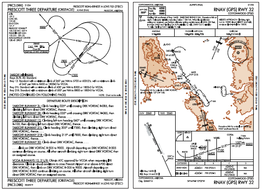
The Prescott Three ODP offers the lowest climb gradient out of KPRC, as long as you use Runway 3L or 3R. You’d probably choose the longer 3R or the wind-facing 12 in real life, but sim challenges don’t always let you choose. After PRC3.DRK, your route is direct to P52, at an altitude of your choosing that’s at least 11,000.
Once you’re established direct P52, ATC begins vectoring you for the RNAV 32. What ATC? Good point … we suppose you’ll have to take on that role yourself. Put on your Approach Control hat and get yourself on the approach. No, you can’t just fly the DRK transition. You must do your best to imitate what ATC would do vectoring you onto the approach. If you could see the minimum vectoring altitudes (MVAs) depicted on the controller’s radar scope, they’d say to remain at or above 9000 until established on the approach. (There is one exception where the MVA reaches 9100, right over the highest terrain between PRC and P52, but we’ll let that slide.)
Departure
How’d it go?
Blindly following the GPS will get you in trouble here. (Seeing a theme?) Let’s take it step by step. First, you must fly a 025-degree heading until crossing the DRK R-085. If your GPS is not connected to an external heading source it only knows track, so it’s up to you to make sure you’re flying heading, not track. Your GPS might then have a waypoint for the radial intersection, followed by a direct course to the DRK VOR.
In Garmin navigators, that’s where it ends, but the actual procedure goes on beyond there. You must continue outbound on the 305-radial until reaching 9000 before making a right turn back to the VOR. Again, OBS mode will do the trick.
Approach
Were your vectors to final spectacular, or just really great?
CFIIs get practice vectoring students to final all the time, usually using their iPad as a radar scope. It’s a good exercise, and a good practice in general to monitor and anticipate ATC’s vectors. The basic vector pattern resembles a large traffic pattern. From this direction, you could set yourself up on a downwind, to base, to a turn to intercept final at an angle no greater than 30 degrees.
Here the quirk is the bend at the FAF. Would ATC vector you on a course of 325, which is an extension of the final approach segment, or would ATC vector you to a course of 315? And if it was 315, would it be inside or outside WEKIG? You’d be vectored onto the approach, to the 315 course outside WEKIG. Even though ATC normally vectors to the “final approach course” it should be the published course outside the FAF. If you like loading vectors-to-final, Garmin will get this right. While ATC can vector close to the FAF by pilot request with ground-based navigation, ATC must vector to at least 3 NM outside the FAF with RNAV approaches. It’s only 2.3 NM from WEKIG to NINTE.
Did you go all the way down to circling minimums?
With the wind, you probably circled. That can be sketchy, but there’s plenty of room for a normal pattern. Level off at pattern altitude, and fly a normal pattern. There’s plenty of lateral room, too. MDAs are the same for Categories A-C, and you have double the visibility required for Cat C. So circling at 4260 MSL you’re afforded 2.9 NM of protection.
That’s it. Just out-and-back, but with a full load of buttonology to keep your fingers as nimble as your scan. And isn’t that part of what IFR has become?


Thanks for publishing this, it was a fun exercise! For the Prescott Three ODP I didn’t even use the GSP for the departure, I set the CDI to the DRK VOR and followed the directions up to 9000.
My only confusion is around the RNAV 32 into P52. The article states “With the wind, you probably circled”. With the wind set to “300 at 12 knots”, why would we circle into runway 32?