
For those of us who dwell in the southern and eastern states, Seattle makes us think of craft beer, grunge music, sprawling Boeing factories, and relentless drizzle and fog. I won’t comment on Pearl Jam or what’s new at Boeing, but I can definitely help decipher the weather. Fortunately the basics are easy to understand. Let’s take a look.
Some Background
We must first learn a bit about the geography. It doesn’t take much vertical motion to get clouds and weather, and in the Northwest there are a lot of things for air masses to bump into. Geography forms the blank canvas that weather systems work with in a mountain environment. The image below is shaded according to elevation—the most important influence on an air mass, after interaction with lakes and ocean currents.
A few things stand out immediately. First is the formidable terrain of the Rocky Mountains, shaded in red to show elevations of over 7000 feet MSL. This covers large parts of Wyoming, Montana, and Idaho.
The broad plateau region on the south side of the map is the Great Basin. Although defined by its lack of river outlets, it also has a unique biological and geographical identity. To meteorologists, this represents a vast high-altitude desert. The average elevation of this area is about 4000 feet MSL.
There are coastal mountains: the Cascades east of Seattle and Portland, and the flatter Oregon Coastal Range, which extends into far western Washington and becomes the Olympic Mountains. The southern edge meets up in California with the Klamath Mountains, and continues south as the California Coastal Range.
The Columbia River dominates most of the Pacific Northwest, largely forming the border between Washington and Oregon. North of Pendleton, it breaks off into the separate Snake River, which angles southeast into Idaho and makes up much of the low-lying basin near Boise and Pocatello.
The Pacific
Here, the Pacific Ocean is made up of a cold current from a flow of cold water from the Gulf of Alaska and wind-driven upwelling from the colder, deeper waters. The bottom of the air mass at the ocean becomes chilled. A cold air mass gradually develops from the bottom up, measuring only about one or two thousand feet deep. This is the marine layer. Because it’s cold relative to the rest of the troposphere, it is warm-over-cold.
The basics of stable and unstable air tells you this is a stable layer that resists vertical motion. At the top, it’s capped by a marine layer inversion, which prevents this cold layer from spontaneously mixing out into the free atmosphere.
Summer Patterns
During summer, strong landmass heating produces a broad low pressure area. This isn’t a specific low pressure center, but rather a broad area of depressed pressure extending across the entire United States and southern Canada, where altimeter settings on most days hover around 29.90 inches. This in turn is subdivided into smaller frontal lows and semi-permanent heat lows with much lower pressure shown on the daily weather map.
Meanwhile out in the oceans, the relatively cold waters help create a cool, dense air mass. This forms an oceanic high pressure area. The altimeter setting in this high pressure area averages about 30.20 inches. If you’re not familiar with oceanic highs, perhaps you’ve heard of the Bermuda High. The West Coast version of this is the Pacific High. Both are strongest during the summertime.
As you might guess, this drives a westerly onshore wind onto the coasts. The bottom of the air mass in contact with the ocean is the marine layer, and on most days it hugs the Oregon, California, and Washington coasts without going past the coastal ranges.
Inland, the weather is delightful. There’s lots of VMC, and winds are light. When the heat builds, however, it can be time to look at density altitude, especially if you’re flying into the mountains, which at places like Sun Valley and Jackson Hole might go above 10,000 feet.
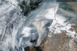
Wildfires have been a significant factor owing to a prolonged drought that began in the early 2000s. Large wildfires can occur anywhere in the western United States, but are rare in central Nevada, the lower Southwest deserts, and the Four Corners. Peak fire season in the Pacific Northwest is August, with southern and central Idaho, north-central Oregon, and far northwest Montana having some of the highest frequency. These can produce vast areas of smoke reaching up to 45,000 feet and reducing low-level visibility to IMC. See figure to the right.
By August, moisture from the Southwest Monsoon filters northward through Nevada, Utah, and western Colorado. You’ll see a rise in the dewpoints and a lot more showers and mountain thunderstorms in the afternoon. This most likely occurs when winds at about 10,000 feet are southerly and there’s already a monsoon pattern upstream.
These are seldom severe, but can produce strong downdrafts and low-level wind shear, especially with unusually dry air aloft contrasting with the moist low-level air—northerly flow at 30,000 feet is often the culprit. This begins shutting down during September as the jet stream gears up and tropospheric flow becomes westerly.
Marine Pushes
Given light onshore flow, we expect the marine layer to move inland as a sea breeze, like in Texas and Florida. However the marine layer is shallow and is blocked by the coastal mountains, as shown below. What little cold air and stratus makes it inland through the valleys is scoured out by inland heating.
Of course with a strong enough shove, you can move most anything. Sometimes the marine layer gets a good kick around or over the mountains and into the inland areas. In the Northwest that’s a stratus surge or a marine push.
That kinetic energy requires a strong pressure gradient—difference in
pressure between the oceanic high and the low pressure inland. The typical 30.20-inch pressure over the ocean and the 29.90-inch on the Great Plains isn’t sufficient. This much contrast needs to be squished into a small distance across the coastal areas.
A heat wave somewhere inland in the Pacific Northwest can do that. This produces a thermal trough, often east of the Cascades but occasionally in the valleys between the Coast Range and the Cascades. The gradient tightens, and the marine layer gets the push it needs to invade the gorges and channels in the Columbia River and the Strait of Juan de Fuca, and move inland.
Of course, the marine layer brings its baggage: a wind shift with vast stratus and fog. The METAR might show CLR, but becomes SCT010 and soon OVC008. During the strongest surges this stratus makes it well into the Cascades. But, none of this survives east of the Cascades—like putting a fish in the desert.
Marine pushes are most common from April to September. In July and August the temperature difference and marine pushes are strongest. So if you hear of record heat in Portland, Seattle. Spokane, or Boise, or see wildfires there, a pressure gradient may be developing, and with it, an invasion of stratus.
Winter
Winter is easy to understand. The pattern just flip-flops. The long nights and the low sun angles cause inland radiational cooling. The air over land
becomes dense and takes on high pressure, averaging about 30.00 to 30.10 inches. Meanwhile the oceans are warmer than the landmasses, especially in polar latitudes. So the oceanic highs weaken and are replaced by a broad, vaguely defined lower pressure. This includes a couple of intense, semi-permanent low pressure centers, like the Aleutian Low in the Bering Sea and the Icelandic Low over between Greenland and Iceland.
In the Pacific Northwest, this pattern is most commonly seen as low pressure off the West Coast with high pressure in the Great Basin area. The result is a prevailing southwesterly wind, but is highly variable with temperamental weather patterns that change daily.
Weather From the West
With the stronger jet stream and increased storminess of the North Pacific, deep frontal cyclones begin affecting the coastal regions. These bring powerful fronts and strong winds to the coasts.
The weather that makes it onshore in the Pacific Northwest tend to bring most of their bad weather behind the cold front. After frontal passage, ceilings will drop, precipitation bands move in, and winds become gusty from the northwest. This is called an anafront.
Clouds and showery precipitation often reach 100 to 200 miles behind the cold front, and only clear up after the low-level thermal trough has left the area. Approaching warm fronts likewise have precipitation with more IMC—beware a frontal system lurking off the Oregon coast with easterly winds.
You might have noticed a wavy appearance of the jet stream as it oscillates north or south. When these waves become large, crossing from the subtropics to the subarctic regions, we call them meridional. This pattern transports dry air southward from the poles, and humid air north from the tropics.
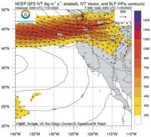
Sometimes this humid air becomes unusually deep, fast, and concentrated, forming a sort of river in the atmosphere feeding northward from the tropics. In the old days this was called the Pineapple Express, but we now call it an atmospheric river, or “AR,” shown above.
This is a firehose of moisture bringing heavy precipitation, flooding, IMC, and thick cloud layers. Count on instrument time in these systems. To monitor atmospheric rivers, just do a web search for “UCSD IVT forecasts.” The plots of IVT (integrated vapor transport) show where these ARs are expected.
Finally don’t forget orographic lift. Whenever air is forced to ascend the terrain, a saturated parcel produces cloud droplets and precipitation. Windward sides of mountains are favored for this kind of weather, while leeward sides are dry. You can widely apply this rule.
Weather From the East
Occasionally during the winter, a strong cold-air mass will develop over British Columbia and move south, or move southwest from Alberta crossing the mountain passes and ridges. This brings some of the most extreme weather to the region.
If there are strong southwesterly winds aloft, overrunning of this cold air mass will occur, producing rain and snow. This is strongest at the gradient between cold and warm air. Such snow affects places like Spokane and Boise, but can spread into Portland and Seattle during strong outbreaks.
These outbreaks also cause strong east-to-west foehn winds that flow through gorges, passes, and canyons where they temporarily channel and accelerate. Gusty winds up to 70 mph often occur with these outbreaks along the Columbia River east of Portland and are about half that in the city. Portland forecasters predict canyon wind events by monitoring pressure gradients between Portland and The Dalles.
If upper-level winds become weak, cold-air masses will stagnate in the Pacific Northwest, and after about two days this will lead to the development of widespread stratus and fog. The Salt Lake City area, the Columbia and Snake River Valleys, and most mountain valleys are vulnerable to this. If left undisturbed, the cloud cover reinforces itself at night and can lead to weeks of cold IMC. There’s usually plenty of VFR just a thousand feet off the ground. Once upper-level winds increase, usually due to a west-east jet stream from the Pacific, this disrupts the air mass and disperses the fog and stratus.
Tim Vasquez served as an Air Force meteorologist in Texas, Nevada, England, and Korea. If you piloted aircraft for Uncle Sam, you might have received a briefing from him, talked to him on the pilot-to-metro radio frequency, or saw him giving the weather report on AFN in Korea.


