
In Wx Smarts, we go beyond the basics you learned in flight school. Sure, you know that winds are stronger at higher altitudes, and that you find fronts near where the jet stream is, but why? What makes the winds flow from the southwest at 20,000 feet when there’s a storm system approaching? Let’s go past the usual weather playbook to look at why the given upper-air pattern is in place. The principles here form a sort of bedrock that will help you understand weather around the globe, which is a big ace card to have when you’re flying into exotic and unexpected locations, whether it’s Waterloo, Iowa or Zurich, Switzerland.
It’s All in the Temperature
Temperature is ultimately what drives all the weather patterns, from seasonal changes to the daily shift in patterns for your cross-country flight. This was recognized as far back as the 17th century, when British scientist Edmond Halley identified heat as the powerhouse that fuels the weather patterns. His efforts helped spark Royal Navy efforts to investigate the trade winds and develop better ways to forecast them for quick trips across the ocean. Edmond Halley, by the way, is the same guy who located that comet bearing his name.
Let’s consider the large-scale pattern. The sun is highest in the sky in the tropics, which means that each unit of solar heat is focused on a very small area. Every day the air mass is comprised of large masses of buoyant thermals which rise through the atmosphere. They only stop once they reach the stratosphere, which is a layer of warm air about 10 miles high in the tropics.
Put a Lid on It
The stratosphere is a layer of unusually warm air. It’s warm because of the presence of ozone, which absorbs harmful ultraviolet radiation and in the process converts it to heat. So we end up with a layer of warm air from about 10 to 30 miles high. The lower boundary is called the tropopause, and it ranges from about FL200 in the arctic regions to FL550 in the tropics.
You might be wondering why the base of the stratosphere is so high if the warm air in the tropics might just add to the stratosphere and help it grow downward. The air rising from the ground expands as it cools, losing heat at the adiabatic lapse rate, initially about 5.5 degrees F per 1000 feet. So by the time it gets to FL500 it has significantly cooled. This contrasts sharply with the warm ozone-fueled layer above.
And to top things off, the air from below is not able to punch into this warm stratosphere. What would happen if it did? Well think about what happens when you bring a very cold blob of air into a region that’s very warm. You might remember this from ground school chapters on stability. The cold blob is negatively buoyant and wants to sink.
This helps keep the layers separated, with the top of the troposphere very cold and the stratosphere quite toasty by comparison. By “toasty” we mean perhaps -50 degrees C while the tropopause underneath is a frigid -80, which is a big difference considering things like potential temperature and adiabatic cooling. In effect, the stratosphere is a ceiling for weather in the troposphere, and weather systems find it much easier to spread horizontally than to punch into it.
Patterns in the Tropics
Over the equator, the upper troposphere is being fed by air rising from below. Where can it go? It can’t go up into the stratosphere. As you might guess, it must spread north and south. So this forms a current of air moving from tropical regions to subtropical regions. This air is deflected eastward in the northern hemisphere due to the Coriolis force, and we soon end up with a river of air moving west-to-east. The stronger segments form the subtropical jet, which we’ll describe in a minute.
All this air accumulating in subtropical regions (near 30 degrees north) tends to pile up, with more coming in from the south, and the Coriolis force is checking its northward movement. There’s only one place for this air to go: down. So we see a broad region where the air subsides. Sinking motion means decreasing relative humidity, clearing weather, and hot conditions due to adiabatic warming. Adiabatic warming is warming from compression, just like an air compressor tank that has just been filled gets warm. Ever wondered what causes the deserts in the Sahara, in Mexico, the Kalahari, and the Australian Outback? It’s this dry sinking air.
The relatively cool ocean waters help increase the density of the air, and this results in massive areas of high pressure over these subtropical ocean waters. The highs we are most familiar with in the US are the Bermuda High (30N 40W) and the North Pacific High (35N 150W), both of which span thousands of miles. This high pressure becomes even stronger and more powerful during the summer months, when the cool ocean contrasts more sharply with the hot land masses. By the time August rolls around, part of the Bermuda High covers the eastern half of the U.S., lapping at the feet of the Rocky Mountains and sending southerly winds across all our airports.
Trade Winds and Monsoons
Some of this subtropical air also splits back southward towards the tropics, feeding into the void caused by rising air near the equator. This belt of winds is called the trade winds. It initially flows north-to-south in the northern hemisphere, but eventually turns right from the Coriolis Force and becomes more of a northeast and east wind. So if you’re flying into the Caribbean or Hawaii, count on these trade winds and more of a northeast component.
Although the tropical region is directly underneath the sun, the solar position oscillates between 23 degrees south and 23 degrees north between winter and summer. The region of maximum heating follows this latitude of maximum radiation, lagging by a few months. Within the maximum heating area we get a belt of low pressure called the intertropical convergence zone (ITCZ). Altimeter settings of 29.60 to 29.80 are common here. The ITCZ corresponds to a band hundreds of miles wide consisting of broken showers and thunderstorms. The flow of moist oceanic air from the equator into this zone of maximum heating is called the monsoon wind.
So as you’ve probably guessed, if you’re flying into the 10 to 25 degrees N area, you can count on July through October being a rainy period. You’ll find extensive debris clouds between 10 and 40,000 feet, with areas of scattered to broken showers that are most extensive during the afternoon and some IMC around the worst of it.
Graphics by the author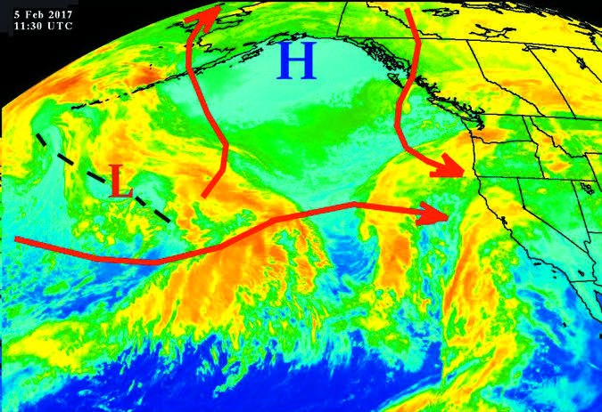
The Westerlies
And now we get into the truly serious weather: the kind that affects the conterminous U.S. and fills endless pages of NTSB reports. As we’ve shown, the belt of subtropical high pressure creates a feed of air from the southerly latitudes, with lots of good weather.
But we also contend with the extremely cold air in the polar regions, where solar angles are low and the ground is only weakly heated. This creates a permanent cold dome in the arctic regions, and like air flowing out of a refrigerator, the air is dense and flows outward in all directions. This sends currents of air southward across Canada into the United States, clashing with the subtropical air. It forms the polar front, which rings the globe.
This impacts you on almost every wintertime flight in the United States because temperature contrasts between two different air masses are what cause winds to strengthen with height. Unless you were snoozing through chemistry class, you may remember the Ideal Gas Law shows that cold air takes up less volume than warm air. You’ve probably seen this with party balloons that become limp when they sit in a cold room for a while.
If you picture air parcels as elastic bricks that can be stacked, and you take a pile of cold air-filled bricks and stack them alongside a pile of warm bricks, you’ll notice that the top of the warm bricks gets taller and taller. Eventually, your cold-brick pile might be only half as high as the warm-brick tower. This illustrates the increasing difference in atmospheric pressure above zones where there are strong temperature contrasts. In meteorology we use an expression called “thickness” to measure how thick these bricks are, and thickness is closely proportional to density and temperature.
Stronger pressure differences means a stronger pressure-gradient force, which then mean the air must flow a lot faster to fill the vacuum. And indeed the wind blows strongly, except it doesn’t quite fill the vacuum, because the Coriolis force pulls the air to the right in the northern hemisphere. The pressure gradient force and Coriolis force soon find a balance with each other that we call geostrophic balance. Unlike air at the ground, most of the air at cruise altitude is in geostrophic balance, and this means the air is flowing in a river from west to east instead of rushing northward to fill the low pressures over the polar areas.
The Jet Stream
The river of air flowing west-to-east circles the globe and is closely tied to where the surface fronts are. So if you’re seeing strong winds at cruise altitude, you can rest assured a front is in the area. Where exactly the front is depends on what kind of jet stream you have.
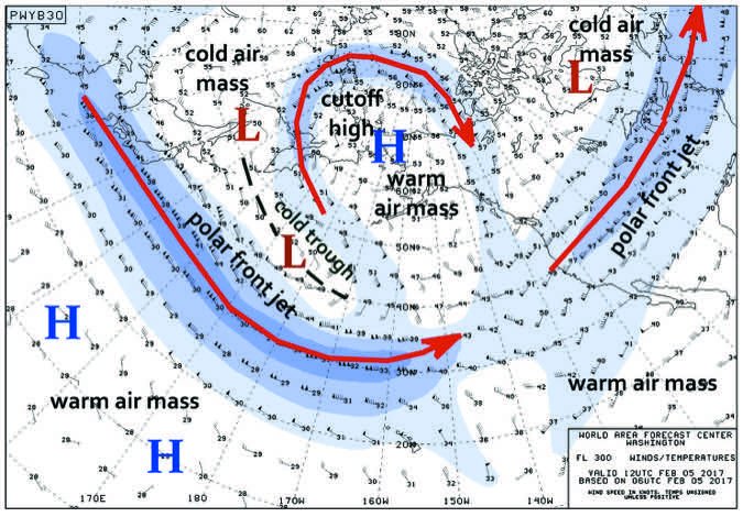
The polar front jet (PFJ) is caused by the subtropical and polar air converging near the surface. If you’re in the core of a PFJ in the northern hemisphere, expect to find the surface front within about 300 miles south of your position. It will be closer when you’re near a surface low. And if you’re flying blind and have to divert, heading north of the jet stream will put you in better weather since this carries you away from the frontal zone.
The subtropical jet (STJ) occurs over the belt of sinking subtropical air, usually between 15-30N but wandering a bit further north and intensifying during the cold season. It’s not caused by low-level temperature contrasts, but rather by temperature contrasts aloft and acceleration of the air coming from the tropics as it flows northward. It can sometimes bring prolific amounts of moisture north from the tropics, helping to give California the “Pineapple Express” rain pattern.
While flying, you can tell if you’re dealing with a STJ because the high winds are concentrated at a higher altitude, typically in the FL300-450 range, and the wind speed increase is often abrupt. You might find 30 knots at FL250 and then 120 knots at FL350. The abrupt change in wind speed means strong turbulence near the interface zone, but fortunately it’s an easy matter to get above or below it. With the PFJ, however, we often see a more gradual transition, with winds sometimes exceeding 60 knots below FL200.
With no surface front around the STJ, don’t expect to find any important weather patterns at airports in the area. But if any thunderstorms do develop, be on guard. The STJ will ventilate these thunderstorms (what meteorologists call anvil-level storm-relative flow), giving them long-lived severe characteristics. There is a risk for large hailstones in the 10,000 to 40,000-foot range, though it rarely reaches the surface because of the high freezing level. Since the air mass wind shear at the surface is weak, these storms are not likely to generate tornadoes, unlike the PFJ that will.
Don’t Make Waves
Naturally the jet stream pattern is very dynamic and goes through huge changes from week to week. We have some terms that describe this. When the maps show weak waves, with the flow going mostly west-to-east, this is called a zonal or high zonal index pattern. This is usually accompanied by fair weather, though jet speeds can get rather strong. In a zonal pattern your main problem is going to be turbulence, especially where it crosses north-to-south mountain ranges like the Rockies, Appalachians, and the Andes. Frontal systems are fast-moving and don’t move very far south.
At the opposite extreme is what we call a meridional or low zonal index pattern. The jet stream shows very large waves, with lots of south-to-north flow and vice versa. Air masses are being moved out of their source regions and there are lots of well-developed weather systems.
This is when TAFs tend to bust since forecasters are dealing with unusual weather patterns and lots of air mass modification. The model forecasts are also prone to more errors, so you should be extra attentive to forecasts and keep on top of AIRMETs and SIGMETs.
The air to the left side of the jet stream is always comprised of low pressure, also referred to as low heights. Where the jet stream dips southward, it is flowing around a blob of low pressure called a trough. Large troughs are always associated with cold air, so when the jet stream is flowing from Phoenix to Denver, you can expect cold weather in Nevada and Utah with an increased risk of icing here. But if it’s flowing from Salt Lake City to El Paso, you can expect the atmosphere to be warmer as you make your way to the West Coast. These warmer areas have high pressure and are called ridges.
Now perhaps you can better understand what’s happening up at higher altitudes. It’s not all that complicated—just put the building blocks together starting with temperature and consider the global circulation. You don’t need to use all these principles to out-think the models, as the computers do a great job. But these concepts and techniques will definitely help you understand your place in the sky among all these systems driving the weather, and give you a framework for understanding where fronts, bad weather, and weather changes fit in. Stay safe up there!


