
The glideslope pegged. Or failed. Or the winds now favor circling. No, you don’t have to go missed. You just have to move the aircraft back into the safe zone.
Pull out your average approach plate for your favorite ILS. What you’re looking at is really two approaches that share a piece of paper: the ILS and the localizer-only. It’s even stated this way in TERPs: two separate approaches.
But that doesn’t mean you can’t start off flying one and decide fate or operational preference dictates a switch to the other, even well inside the FAF. You paid for both approaches; you might as well get your money’s worth.
Two Separate Radios
The localizer is a VHF signal similar to what Jimmy Doolittle used for his first zero-zero takeoff-and-landing demo. It provides only azimuth guidance to the airport/runway complex, and is considered a non-precision approach because we don’t have a descent angle to the ground presented to the pilot on aircraft instrumentation.
Some installations can’t have a glideslope due to magnetic or terrain influences and thus you’ll find localizer-only approaches without an option for an ILS. Variations on the theme include the Simplified Directional Facility (SDF), which shows up at many of the “lower-budget” airports. There are also Localizer Directional Aid (LDA) approaches that use a localizer beam but with issues that make it unsuitable for a true localizer approach. Usually it’s offset to a runway at too great an angle, but sometimes it’s because there was a localizer signal from a totally different airport that just happened to point the right way for an approach. (See the LDA-C at Van Nueys, Calif.)
The glideslope portion is a UHF signal and seems to be a bit more cantankerous. There is some real magic performed in producing the glideslope to be received by, and displayed to, pilots and with that magic comes some problems. (A bit of history: The ILS was first bolted down around 1937 at Oakland as an experimental approach, but soon became an operational system. The localizer portion in the VHF signal band seemed more manageable and VOR navigation appeared in the same band, but later on.)
Almost every VHF aviation receiver for the VOR band also receives the localizer signals. You can check the AIM for the localizer frequencies. In the early days, there were only 20 localizer frequencies, but with the advent of 50-kHz spacing we have 40 localizer frequencies.
In the really early days, the UHF glideslope frequencies had to be selected on a separate box in the radio stack. Today, one UHF glideslope frequency is assigned to each VHF localizer frequency and the pilot simply tunes the localizer and lets the avionics magic do the rest. The AIM shows the frequency pairings.
Reception and display to the pilot of the UHF glideslope signal in conjunction with the localizer signal gives us the complete ILS system and what we enjoy as a precision approach. This precision approach gets pushed further into Cat I, II, and III “how low can you go” minimums. These installations get checked for exceptional signal integrity for those last couple hundred feet of descent.
So you’ve got two radio signals, one required for both approaches and—one of which is only required for the ILS flavor—and that optional one is both more cantankerous to receive and more sensitive (harder to fly). So the question comes up: What should a pilot do if the glideslope signal is lost or goes out of view (“pegged,” as we say) during an attempt at the ILS approach? To fully understand our options, we must first look at the airspace allotted.
Trapezoids and Ramps
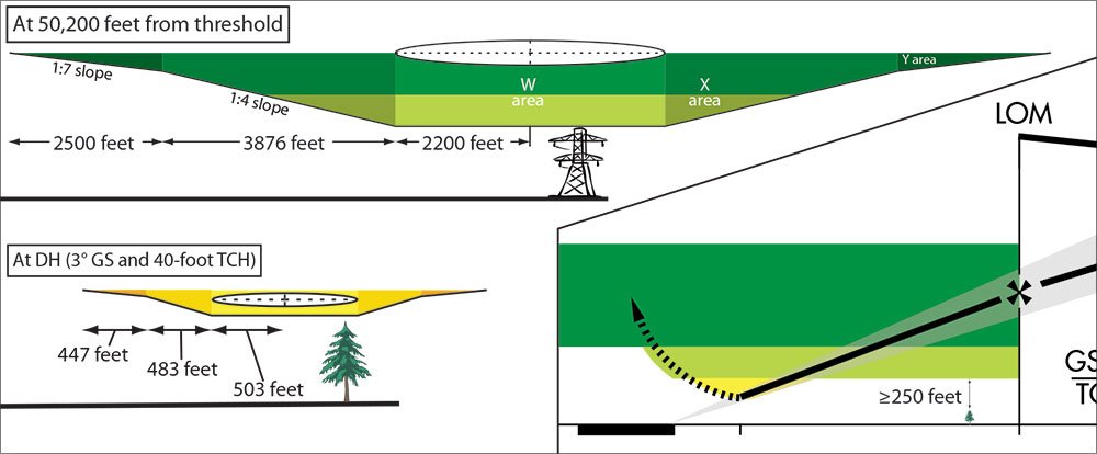
Prior to glideslope intercept, you are flying in what TERPs calls the “intermediate segment,” and have at least 500 feet of obstacle clearance. The glideslope intercept point is the FAF for the ILS, and is a plumb-bob point on the ground where the perfect glideslope beam intersects an altitude along the intermediate segment from a perfect altimeter on a standard day.
In the old days, when beacons were used in IFR flying, the outer marker was placed as close to this point as possible. Outer markers are no longer a part of the ILS system and are being removed.
The marker used to be the FAF for the localizer-only approach as well. Now the FAF is marked by some other navaid, intersection, DME or even the glideslope intercept itself.
The final approach portion for the localizer approach is a vertical trapezoid whose bottom is at an MDA of not less than 250 feet of obstacle clearance. Picture this MDA as a floor (“hard deck” for you Navy types) extending all the way from below the FAF to the localizer MAP, which is usually over the first brick of the runway. So long as you are within the lateral limits of the trapezoid—on the localizer—and above the MDA for the localizer-only approach, you’re in protected airspace.
It doesn’t matter how you descended—on the glidepath, dive-and-drive or a casual drift down. If you started out attempting an ILS and have glideslope problems above the localizer MDA, you can descend to the localizer MDA, continue to the localizer MAP and look for an opportunity to land.
The reverse is also true: If you peg the glideslope needle on the top of the case but you’re still above MDA, you can level off in the protected airspace of the localizer approach as low as MDA if you want, recapture the glideslope and continue on down. Life on the ILS above the localizer-only MDA is not threatened much by Murphy.
It’s a different story below MDA. Being above the glideslope is workable, but the condition of being below glideslope is simply bad. TERPS protects the ILS with an inclined plane of obstacle clearance of a lesser angle than the glideslope beam. Obstacle clearance is thus decreasing from the moment you first start down the glide path all the way to DA.
Above MDA, you don’t care because you and that slope are well within the protected trapezoid. But between MDA and the lower DA, you are in the zone of minimum obstacle clearance for any published approach type. For this reason, most view more than one index low on glideslope as unacceptable when below the MDA. More than one index high may also be unacceptable per company policy, but it’s not a collision hazard.
But you still have options besides going missed. If you don’t like your glideslope position below the MDA, or your glideslope electronics fail, you can initiate a climb back up to at least the MDA and continue on with the localizer portion to the MAP and try for a landing—which was the original intent.
Practically speaking, it’s usually a short time between descending below MDA on the glideslope and reaching DA, so it’s an unlikely scenario to get a failure while still IMC, climb to MDA, proceed to the MAP and actually break out for a runway to land.
But it is possible you might want to abandon a late-stage ILS. Suppose, as you get close to the runway, the windsock makes it clear this would be a nasty downwind landing. The circling MDA can’t be lower than the localizer MDA and is usually higher. But there’s no reason you can’t climb back up to the circling MDA and switch plans for a circle-to-land just because you made the decision late in the game. Just don’t start the circling maneuver until you’ve got the required altitude.
Now you say, “Old Dog, where do I go missed approach? I was primed to go missed when I reached DA, but now I am flying a different approach?”
The short answer is that close counts in hand grenades, first dates and instrument flying. You can climb straight ahead and use an estimated point where you would have hit DA, the MAP for the localizer-only approach or even the little runway numbers on the little runway on your moving map.
Don’t be in a hurry to turn. The assumed turn radii for the missed approach (on all precision approaches) starts at 1.5 miles down-track from the DA or MAP, and the two approaches (localizer-only and ILS) share a common missed approach procedure. Climb, clean up and fly the missed.
Glideslope Optional
Of course, all of this just applies to vertical guidance. Failure of the localizer signal is Murphy’s worst trick. Without lateral guidance, you are in deep kimchi, and winter (spicy) kimchi at that. Here is where the GPS will save you—be it hand-held or panel-mount. Just stay on a course to the general airport area (runways are conveniently devoid of obstacles) as you climb. Sometimes the FAF has a navaid colocated and you can switch back to VOR guidance if the problem is with the localizer array. It’s better than nothing.
Switching back and forth on an ILS from precision to non-precision is not a big deal. You may even want to include this concept in your approach briefing (and training) so as to be better prepared in case Mother Nature or Murphy decide to mess with you some day.
Counterpoint: Go missed now
Final approach is no place for uncertainty, which is why I’m not a fan of brushing off a glideslope problem and simply switching to a localizer-only approach. Granted, this habit dates back to the pre-GPS era when that localizer needle was all that stood between me and eternity.
Here’s my thinking: If I’m switching because of an operational need, such as deciding to circle, that’s no problem. I have certainty about where I am and confidence in my avionics. I’ve just decided a change of plan is in order and as a reasonably competent instrument pilot I should be able to rebrief the new numbers in little time and a minimum of distraction.
If I have a good GPS with a moving map and I lose the glideslope, I’m OK with continuing because my GPS can confirm that my localizer needle is still giving me reasonable guidance. But if two instruments seem at all incongruent, I’m outta there.
If I have only a CDI with vertical and horizontal needles and partway down the glideslope the vertical guidance fails, I’m going missed. Sure, the localizer guidance may be fine—probably is fine—but I’ve lost my feeling of certainty that it is. Did the UHF receiver or groundstation for the glideslope fail? That wouldn’t disrupt my localizer. But what if the problem is in my all-in-one VHF receiver and I’m about to lose all guidance? Or what if when I went to swap comm frequencies to announce on CTAF I actually swapped navs and followed the VOR signal for 30 seconds before I noticed the flagged glideslope? Or … or…
The point is that I don’t know why the glideslope is busted and final approach isn’t the place to troubleshoot. I’d rather sacrifice some time setting up to try again than sacrifice myself to the gods of chance. —Jeff Van West
Dog Brenneman used to fly F-4s. These days he flies G1000 172s. In both, a life-study of instrument procedures has kept his fanny from harm.


