
I recently got a question from a reader: “When you are flying in clouds and the ride is bumpy, is it bumpy because it’s cloudy or is it cloudy because it’s bumpy?” Good question. Turbulence is often approached from a rather pragmatic approach in aviation, and that often leaves pilots with questions about where it fits in with weather patterns.
Let’s look at this piecemeal. From a meteorological perspective, turbulence is bumpiness caused by flight into an area where wind is changing over a small distance. And we’re talking very small distances. While flying at 150 knots and being pulled upward one second, downward the next, and up again after another second, we can see that these changes are on the scale of hundreds of feet, and often even smaller. They may exist as areas of wind shear, where wind speed and direction is changing sharply from one location to another, or as turbulent eddies, where the wind flow has broken into a whirl, like a wave.
But scale is crucial: Some eddies or shear areas may be large, measuring many thousands of feet in size, which means you can react to them by just trimming the airplane and enjoying the view. Some eddies may be meters or centimeters in size, so small that the aircraft doesn’t even have time to react. It’s the ones in between, on the scale of tens or hundreds of meters, that really have the special ability to affect your ride. The smaller of these you will feel as chop.
Clear Air Turbulence
The phenomenon of clear air turbulence (CAT) was discovered by WWII crews who puzzled over being bounced around when there was no stormy weather in the area. Meteorologists at first thought these were areas where fronts were forming. However they quickly realized the cause was Kelvin-Helmholtz instability, where fluids moving at different speeds shear apart and form whirls. The bands, loops, and swirls ringing Jupiter and Saturn are excellent examples, and animations of them can be viewed on the Internet. Where laminar flow breaks up into bumps and whirls, you have CAT.
Recent studies have shown that the most common altitude for clear-air turbulence per flight hour tends to peak at FL350, with moderate to severe turbulence preferring FL300. There is also a strong tendency for it to occur in the winter months, with late December and early January being the worst.
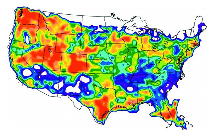
In the United States, the most turbulence reports per flight hour are centered on Colorado, with a very broad area across Indiana and Ohio. There’s another region in Oregon and Washington. But of course no part of the country is exempt, and clear air turbulence can occur well below 18,000 feet, so it can definitely affect both the piston and jet crowds.
Since CAT is dependent on shear, it is found close to the periphery of strong jet streams, particularly above and below the core, and occasionally poleward of the core. Likewise, since jet streams are almost always found poleward of fronts, you can expect to find CAT north or west of cold fronts and north or east of warm fronts in the northern hemisphere. Subtropical jets can produce CAT, too, and here there is less of an association with surface patterns and you have to look at the upper air charts.
As a general rule, when there is 20 knots of horizontal shear across 60 NM or six knots of vertical shear across 1000 feet, moderate clear air turbulence will be the result, with 30 knots and nine knots the values for severe CAT. These zones tend to be shallow, so ascending or descending by a few thousand feet can be all that’s needed for a smoother ride.
Mountain Wave Turbulence
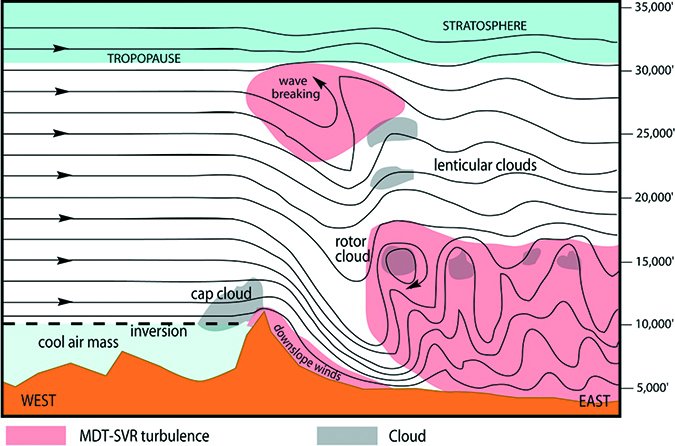
Mountain wave turbulence is caused by gravity waves and interaction with strong winds across terrain. It occurs whenever there are strong winds perpendicular to a mountain range, such as westerly winds crossing the Sierra Nevada or Rocky Mountains. The highest risk areas for mountain wave turbulence in the United States focuses on three main areas: western Montana, northcentral to southcentral Colorado, and eastern Nevada. Mountain wave turbulence peaks in January, and is least in August.
Two main problem areas exist. One is the lee side of the mountain range in the low levels. Air moving away from the mountain ranges breaks up into roll clouds and rotors. And the wind flow on the leeward side may not only be bumpy but may have a very strong downward component, similar to a thunderstorm downdraft, and can put low-flying aircraft in an uncontrollable situation.
The other area is at high altitudes, affecting mainly airliners and business jets. Near the tropopause, the gravity waves flowing over the mountains often go through a wave-breaking process, similar to waves crashing on a beach, and this generates areas of moderate to extreme turbulence.
Where can you find these areas? A good rule of thumb is that the wave-breaking regions are found 2000 above to 6000 feet below the tropopause, and anywhere within 50 miles downstream of the mountains. The low-level hazard area, on the other hand, exists from the surface to about 7000 feet above the mountain peaks, and again, downwind of the mountains. If you see rotor clouds, this is the altitude where turbulence is the worst.
Pilots need to be aware that mountain wave turbulence produces the most violent type of turbulence outside of thunderstorms. In 1966, a BOAC Boeing 707 broke up near Mount Fuji while climbing through 16,000 feet. The cause was mountain wave turbulence, and a telltale sign came from a passenger taking a home movie; the last portion of the film showed a view out the window and then the floor carpet.
To stay safe near mountain wave turbulence, first and foremost never fly at low altitudes along the lee slopes of mountain ranges. Downdraft components may force you to the ground. Moderate to severe turbulence will be found downwind of the mountain range, but in many cases the ride will be slightly smoother at medium levels, about 15,000 to 25,000 feet. Also be aware that IFR conditions may exist on the windward side of the mountain range, particularly in situations along the West Coast and Appalachians.
Turbulence In Clouds
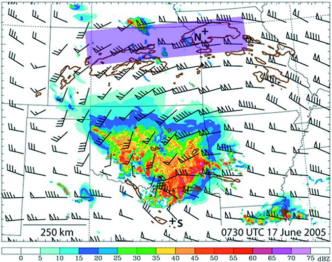
Turbulence in clouds is generated by the updraft and downdraft motions embedded within cumulonimbus and cumulus clouds, with lighter currents in stratocumulus and nimbostratus. If the clouds are generating showery precipitation, moderate or greater turbulence is a possibility, and airborne radar and/or spherics (Stormscope/Strikefinder) are your best tools for staying safe.
Strong radar echoes will paint the strong downdraft area and the top of the updraft column, but the base of strong thunderstorm updrafts are frequently free of large precipitation drops. In tornadic storms this “weak echo region” can extend up to 20,000 to 30,000 feet or more, so even radar is not guaranteed to keep you out of it. The rule of thumb is to give wide berth to all intense precipitation areas.
I include downbursts and microbursts in this category, because the processes are the same: flight into convective cells, bringing the aircraft through numerous downdraft and updraft cells. However downdraft cells near the ground spread horizontally, bringing not only vertical speed changes but also sharp airspeed changes. This brings us to the topic of microbursts, which have made aviation headlines for decades and are a topic worthy of a separate article. Readers should not get too hung up on the definitions of a microburst, however, because all thunderstorm downdrafts reaching the ground are hazardous and have the potential to create microbursts.
A unique type of turbulence, referred to as “convection-induced turbulence” (CIT) describes turbulence around a storm anvil or above the storm itself. With CIT, there is no penetration of the storm precipitation, nor is there any clear air turbulence. Numerical modeling has shown that the cause is gravity waves caused by the thunderstorm propagating into the surrounding air, like the ripples that move away from a rock that lands in a pond.
To avoid CIT, simply follow the FAA guideline more stringently for avoiding storms by 20 miles. You must avoid not only the precipitation areas by 20 miles, but the anvil cloud formation, too.
Low Level Turbulence
Low-level turbulence occurs in the boundary layer, which is the air mass closest to the ground. At night, the boundary layer can range from a few feet deep on a clear calm night to about 2000 feet deep when it’s cloudy and windy. The boundary layer is deepest in the early evening where it is normally about 3000 feet deep but can range up to tens of thousands of feet on a hot summer day in the desert.
The main prerequisite for low-level turbulence is unstable air, which is essentially cold-over-warm. This encourages small vertical motions to grow into larger ones and helps turbulence develop. The most common sources of unstable air are solar heating, the passage of cold air over warm land and water bodies, and upper-level lift. This instability significantly modulates the two main types of low level turbulence: thermal and mechanical turbulence.
Thermal Turbulence
With a source of surface heating, the air mass can develop thermals. These can be quite strong, enough to keep glider pilots happy for many hours. This alone, without any wind, can create shear and eddies in the atmosphere and bump air traffic around. If you’ve taken an airline flight into Las Vegas or Phoenix in June, you know what I’m talking about. This is what we call thermal turbulence.
Thermal turbulence is normally light to moderate. It starts out in the lowest 2000 feet during the morning, but by afternoon the strongest turbulence is found about 3000-6000 feet AGL. So in the morning, higher altitudes will get you out of the worst, but late in the day it might be better at lower altitudes. Also keep in mind that the strongest thermal turbulence is found along slopes facing the sun—the south sides of mountain ranges.
Thermal turbulence may be quite deep, topping out from 5000 to 10,000 feet AGL during the summer months and up to 20,000 feet over the deserts. The haze layer, if you can see it, is a good marker for where the top of thermal turbulence can be found.
Mechanical Turbulence
Another source of turbulence occurs when we have strong winds, caused by the presence of a tight pressure gradient in the region. It’s not 30-knot winds alone that produce turbulence. After all, this is pitifully small compared to jet stream winds. The cause is related more to frictional effects at the bottom of the air mass as winds scrape over trees, crop fields, hills, and buildings. This creates a speed differential between the surface and air a few thousand feet high. It produces what we call mechanical turbulence. Instability does all the rest, by helping eddies form and expand vertically.
Finally rough terrain is an ingredient that amplifies mechanical turbulence and produces deeper, more intense eddies. If you find yourself flying into a valley where strong low-level turbulence is taking place, it’s better to stay away from airfields along the foothills and fly over flatter terrain.
A good rule of thumb for mechanical turbulence is if surface winds are over 30 knots, expect moderate turbulence. Sustained winds of 20 knots or more will cause 10-20 knots of airspeed fluctuations and provide good reason for you to add power during your approach. Low-level wind shear (LLWS) can be expected with almost all moderate to severe mechanical turbulence, but it can be enhanced due to terrain effects or when there are strong directional changes in the lowest few thousand feet of the atmosphere.
Mechanical turbulence tends to be diurnal, so you can use this to your advantage. If the weather is fair and there are no frontal systems in the area, mechanical turbulence will max out around 11 a.m. to 2 p.m. It then gradually decreases during the afternoon as winds subside.
Staying Safe
The foremost key to dealing with turbulence is reducing airspeed—as most of you do naturally. Slow to maneuvering speed. Some pilots may be concerned about stalling the wing during a particularly strong gust, but these gust-induced stalls are transitory from which the wing recovers quickly.
The second key is being gentle with the aircraft. The American Airlines A300 that went down near JFK in 2001 is an excellent example of this. The aircraft was well below maneuvering airspeed limits but succumbed to wake turbulence because of, according to the NTSB, the “first officer’s unnecessary and excessive rudder control inputs.” It’s important to keep in mind that control inputs add up with turbulence inputs in a way that can easily exceed the aircraft’s capacity.
Next, gently try to keep the wings level. This keeps the aircraft in its most stable configuration and minimizes the risk of control loss from a particularly severe bump.
All of this suggests that it’s best to hand-fly the aircraft and ride out the turbulence rather than fighting it. By doing this, there’s little risk of loss of control, and the stress on the airframe and your passengers is minimized. This runs contrary to the philosophy hammered into us to never risk an altitude deviation, but it only takes a few seconds to let ATC know about the turbulence problem and potential excursions.
Finally, check out the turbulence page at the Aviation Weather Center, which offers not only AIRMETs and SIGMETs but some excellent graphics for CAT and mountain wave turbulence.
You should now see that turbulence and clouds are separate entities. Turbulence just needs air with shear and eddies, while clouds need saturated air and lift. Some clouds, like cumulonimbus, can provide the shear and eddies. Stay away from those and you’ll be around for more Wx Smarts.
Tim Vasquez is a professional meteorologist living in Palestine, Texas. See his web page and his various materials at www.weathergraphics.com.


