
When operating near large bodies of water, especially on the west coast of the United States, you might encounter the “Fog Monster” from the excellent article by Tim Vasquez in the May, 2013 IFR. Since I’ve spent over 20 years under the spell of this weather pattern, I’ve learned that fog is only a symptom of the marine layer that spawns it. So, the monster could be actual fog or low, dense clouds.
Here’s an example. On a leg from the east to my coastal home base in Northern California I began listening to the AWOS around 25 minutes out. It reported scattered clouds at 1100 feet with 10 miles visibility. Ten minutes later I checked again and scattered had turned to broken at 1100. That quickly turned to 1100 overcast, became 800 overcast, and then 700 overcast.
I joined the localizer over the Monterey Bay with AWOS audible on my number two com. By the time I reached the FAF the ceiling was 400 overcast and two miles visibility. After missing in solid IMC without the slightest hint of an airport, I flew an ILS to minimums at nearby airport. By then my home airport was also 200 overcast. The marine layer caused the airport to go from VMC to below minimums in about 20 minutes. This is common.
Marine Layer Weather
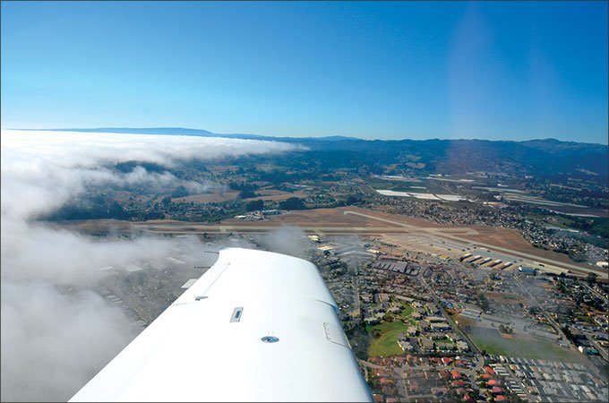
Unlike the somewhat more predictable weather at most inland airports, the coastal weather patterns can be quite fickle. Often the marine layer, usually wielding a frontal wall of gray with tops from 1000 to 2500 feet, will be waiting for an invitation to come ashore. Satellite photos will show whether it’s lurking a few miles out to sea or hugging the shoreline. It may spring ashore as a wall or may appear to independently form as an overcast over the land.
This gray wall can lurk menacingly off-shore for days. Sometimes, it acts afraid of the sun. It might venture ashore each evening, boldly strengthening overnight, only to be forced back to its lair in the sea by the warmth of the morning sun.
But it’s a wily beast. It can change its behavior to catch the overconfident pilot off guard. Sometimes, after a clear night it might appear with dense fog at sunrise or simply form as a ceiling at any time during the day.
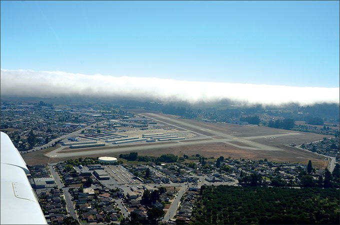
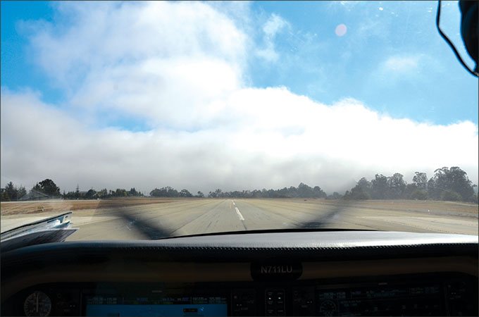
It can even be a tease. At my airport you occasionally see part of the runway in the sun and the other half engulfed in near zero/zero fog. It can remain like that for hours, then retreat, or suddenly swallow the entire airport. I’ve landed in the clear and taxied to parking only to have visibility turn to almost nothing while I taxi, requiring me to timidly inch along looking for my tie down.
Yet, there are still certain patterns. As unpredictable as this beast can be, like most weather, tomorrow’s behavior is likely to be a lot like today’s. You’ll be ahead of the game if you observe the weather for a few days before your planned flight. Start with the terminal or area forecast, the satellite photos and the current airport weather. Watch closely as the layer ebbs and flows throughout the day. Observe the current weather pattern and, when it’s time for your flight, verify that the same pattern exists for your ETA.
Read the Tea Leaves
Note the weather up to 100 miles inland. If it is hot and clear, the rising warm air over land draws the cool, moist ocean air inland, and typically the marine layer comes with it. It helps moderate temperatures on the coast, but can wreak havoc on flight operations.
There are multiple clues when the monster is on the attack. The temperature/dew point spread will be closing and the faster they close the quicker you can expect clouds or fog. You can follow hourly observations at weather.gov/data/obhistory/KJFK.html, substituting the code for your airport. Also, as the temperature and dew point begin to converge, a cool 10-15 MPH onshore breeze is a strong indication that the marine layer is coming ashore. Finally, the continuing appearance of scattered clouds anywhere from a few hundred feet to a couple thousand feet usually means that a ceiling is forming rather than the wall moving inland. It can appear, turn broken and then overcast in mere minutes.
You are trying to learn the times when the airport is most likely to have good enough weather to facilitate arrivals or departures. When the marine layer is persistent, the clearest skies will typically be in the early to mid-afternoon after the sun has broken through and before the clouds return later in the day. This window may never come or can be surprisingly short, but most days you can expect at least a couple hours of reasonable weather.
Watch the weather at more than just your destination. Many coastal areas have local geography-based microclimates. California’s Monterey Bay has three airports within approximately 20 miles of each other. One might be at 200 overcast or less, one at 1200 scattered to broken, and one with clear skies. Know the overall picture so you’ll have a sense of how pervasive the marine layer is and where you might find a nearby alternate.
Remember that the AWOS/ASOS takes a narrow look at the sky, essentially directly overhead. Thus, it can be easily fooled by the clever beast, and report clear with the other end of the airport below minima, or vice versa. You should always take a look; one runway will often remain clear as the layer advances. Manual observations for ATIS can get a more complete picture, but may not be current when things change rapidly.
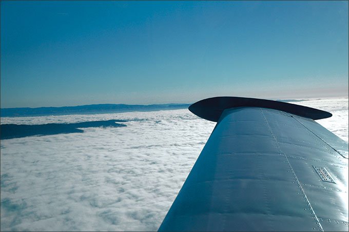
You’re not necessarily safe when it’s clear and a million, either. This can be a sucker play for what’s to come. If you’ve never seen it, imagine a region of scattered to broken undercast clouds at 2000 feet or less. Then, imagine it turning into a solid white undercast for as far as the eye can see with maybe a few small mountains protruding into the sunlight. That’s a pervasive marine layer at work. The three pilot axioms, check the weather often, be prepared early, and have a backup plan truly apply to operations near coastal environs. If you’re planning a trip to a coastal airport you should always have a “golden” alternate with acceptable weather.
IFR Strategies
At a coastal airport it may be more important than normal to review the IAPs for your destination and any likely alternates. You’re not necessarily just looking for the approach with the lowest minimums. Winds are generally onshore under the influence of a marine layer, and may not favor the optimal IAPs. Sometimes a circle to land at the other end of the approach runway may be your best option.
There are also cases where an approach with higher minimums to a clear runway might work while an approach with lower minimums to an obscured runway might not.
For example, my home airport has both a Localizer with MDA of 700 feet and a GPS (LPV) approach with DA at 445 feet. These would seem to be a better choice over the VOR/DME-A approach with its 1300′ MDA. Yet when arriving from the south, the VOR approach with a circle to land is essentially direct to the airport where the other two require vectors out over the ocean to an IAF and then inbound, usually downwind. That often adds many minutes to the arrival. If the weather has started down but ceiling and visibility are still acceptable, the VOR approach even with its higher minimums can be a savior, especially if the monster has already consumed the end of the other runway, but hasn’t yet reached the rest of the airport.
If you’re VFR make sure you’re receiving flight following. Once you’re in the system it’s often easier to obtain a quick IFR clearance for an approach. It’s also easier to know if there is a queue waiting for the approach if you monitor the approach frequency, helping with an early decision to conserve fuel or divert to an alternate.
If the airport has an IAP you have the option of a “contact” approach. This can be useful if, for example, you can see the airport under the overcast, often from the end of the encroaching monster. This can be a valuable option if you’re familiar with the area and the obstructions, or a disastrous one if you are not. Choose wisely.
Speaking of potential of traps, here’s another. Assume you’ve completed an IAP and as you start the missed the other end of the airport magically appears below or behind you. This can be a fortuitous opportunity to cancel IFR, roll it around and land. Like the contact approach, though, it can be an invitation to disaster if the fog continues its advance and catches you in IMC but on VFR. This is another option best left to those experienced with that particular airport.
Departures
Departing a coastal airport experiencing marine layer weather is reasonably straightforward, but has a few traps of its own. An IFR clearance would normally be the preferred choice. But if your flight is to be VFR you can request an IFR to VFR on Top or even just “IFR to cancel on top.” From appropriate airports, Special VFR can also work, but might be denied.
The one trap to avoid, though, is launching directly toward the advancing clouds and fog. Distance to the monster from takeoff position may be difficult to determine and ground references may help. More than one accident has resulted from a pilot continuing to pull up into a stall to avoid IMC. It’s best to get an IFR clearance, even if it takes longer to get it than you’ll use it.
Finally, there’s the old question of take-off minima. There is no departure visibility requirement for a Part 91 take-off. You should always consider your options for an abort or a return to the airport when departing in low visibility. Plus, you are flying the obstacle departure, aren’t you?
Airports near large bodies of water are subject to marine layer weather. Most of the time flight operations aren’t a problem. But there’s always the potential to get caught and a good pilot respects the risks that low clouds and fog present. Take the time to plan ahead so you can enjoy the wonderful coastal area when you arrive safely.
What Visibility do You Need?
In the article, we talk about landing in the clear, but rolling out into zero-zero.
Is that legal?
The key to this is understanding the airspace in which you’ll conduct the airport operations, that is from the surface to your traffic pattern altitude.
Let’s start with a look at controlled airspace—all but Class G airspace.
If you read 91.155 carefully, you’ll note in paragraph (d) it says in controlled airspace you need surface visibility, if reporting, for operations at an airport. So, even if the surface is Class G, if the pattern is in Class E, the official surface visibility report controls. Easy enough, but now let’s consider our marine layer foe.
On its march inland, the marine layer usually first attacks the part of the airport closest to the coast, then as it continues its advance, the entire airport. If the official visibility sensor is at the side of the airport closest to the coast, it could easily be reporting less than the requisite visibility, while the other side of the airport is in the clear. In this case, the official surface visibility says you are not legal to operate VFR at that airport, regardless of which runway you’ll use. Of course, it could also be that the sensor is in the only clear spot on the airport.
But this is only an issue if surface visibility is being reported. If the report is below the three miles of visibility, you might be able to call your buddy the airport manager and ask him to shut off the ASOS for a bit so you can revert to using flight visibility that you’ve got in spades over on the other side.
Class G has no such surface visibility requirement. So, if you can perform all your operations to or from the airport without leaving Class G or falling below its much lower flight visibility requirements, you may land or depart under visual flight rules, regardless of what the AWOS/ASOS is saying.
Oh, and Special VFR at towered airports has the same official surface visibility report requirement, even if flight visibility is unrestricted. —JS
Joe Shelton flies his Columbia 400 from Watsonville, California, where he’s long struggled through the attacks of the fog monster.


