
Without a doubt, the western United States offers the best VFR flying in the nation. This is partly why the military has its air combat training centers in Arizona, Nevada, and California. Most likely you’ve also done some cross-country trips in those areas and had no problems.
But this area is not without its hazards and peculiarities. The landscape and nearby oceans complicate the forecast picture, so when things go downhill, things can get quite difficult. Forecast models have always had difficulty factoring in these effects. And the effects of climate change have also brought with it some new flying problems which we’ll discuss later.
Background
Weather in the western states is heavily shaped by the effects of land and ocean. Tall mountains, cold ocean currents, and hot deserts are all strong influences on the weather, and must be factored with the basic weather patterns themselves. So let’s outline the important players.
First is the vast desert region itself, devoid of much tree cover. This includes not only the Sonoran and Mojave deserts but the Great Basin Desert further north in Nevada and Utah. Incoming sunlight overwhelmingly hits rock and sand, which effectively absorbs solar radiation. Due to the rock’s low specific heat, this radiation is put back into the atmosphere as heat through conduction. This produces powerful thermals that aggregate into convective updrafts. Naturally this air is quite dry.
Then there’s the Pacific Ocean. If you’ve ever jumped into the water at a California beach, you know the water is rather cold. This is because a large cold current originates from Alaska and flows down the coast all the way to Mexico year-round. It provides a powerful moderating influence on Washington, Oregon, and especially California, where it tempers summer heat along the coast.
Next there’s the Gulf of California. Measuring 700 miles long, this is found south of Arizona, dividing mainland Mexico from Baja California. It is shielded from the cold Pacific current, making it an important moisture source, mainly in the late summer when this moisture gets entrained in southerly flow and advects to Arizona and California.
We also have the Sierra Nevada and Rocky Mountains. These north-south barrier ranges are known for their orographic effects, as air masses flow across the wet windward side and the dry leeward side. These mountains are also prolific generators of clear-air turbulence (CAT).
Finally in between the Sierra Nevadas and Rockies is the Great Basin region, a vast plateau region stretching from Las Vegas, Flagstaff, and the Painted Desert northward to Spokane and Boise. This region has an average elevation of about 4000 feet and effectively radiates its heat away during the winter, making it a cold desert.
But to truly understand in detail how weather in the western states works, we must start with the temperature balance between the two great source regions: the Pacific Ocean and the inland desert regions. This changes with the seasons, so weather forecasting is categorized according to the time of year.
Summer Weather
During the summer, strong heating dominates the western states. We often think of this heating as being strongest in Phoenix, Las Vegas, and Death Valley. But consider Salt Lake City, which reaches an average of 93 degrees in July and lies at an elevation of 4200 feet. Adjusted adiabatically to sea level, this translates to a temperature of 118. This is a testament to the vast amounts of heating that take place across all of the western states, from Washington and Idaho all the way to the border of Mexico.
This results in widespread, slow-rising motion, on the order of centimeters per second on average, and transports lots of mass to the top of the troposphere. This helps produce an upper-level high pressure area, or an upper-level ridge that often persists for weeks. Combined with the lack of air-mass contrast polar jet formation is unlikely, so upper-level winds are usually weak.
The strong heating in the deserts also leads to the development of a broad low pressure area at the surface, due to the low density of hot air. You’ve probably noticed the semi-permanent low that always sets up over Yuma, Arizona, in July. This is a thermal low, which often wanders over to Phoenix or up to Las Vegas. But if you look past the thermal lows and examine the isobar patterns, you’ll notice it paints out a much larger low-pressure area covering the western states. It often joins a lee-side trough, connected with the jet stream, somewhere between Alberta and Colorado, and this results in the pattern we commonly see on the weather charts in the summer.
And of course the effect on density must be mentioned. The Great Basin and Rockies are where “hot and high” flying is the rule. When I worked at the Tonopah Test Range in Nevada we had several days in the summer where the density altitude approached 10,000 feet. Our actual field elevation was 5500 feet. A situation like this can lead to a dangerously long takeoff run if you’re heavy.
Monsoons and Marine Layers
The broad zone of low pressure gradually starts pulling in moisture from the tropics. This starts out in Mexico in May and early June, and reaches New Mexico by late June. During the month of July the moisture reaches Arizona and Utah, and by August is found throughout the western states. This is the Southwest monsoon, and brings a bump in dew-point temperatures, more clouds and precipitation during the day, and increased chances of thunderstorms. These storms usually form on mountain ranges and move out into the valleys with the prevailing deep-layer winds. Most of these storms appear around early afternoon and dissipate around midnight.
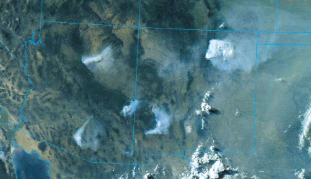
Due to the tendency for weak upper-level winds, severe, organized storms are not favored. The biggest threat from Southwest storms by far is localized downburst winds, along with lightning and flash flooding. If the ground is dry, such as at the start of monsoon season, downdraft winds can pick up dust and produce dust storms. Most are localized and brief, but large events can loft dust up to heights of 20,000 feet and take all night to settle out, obscuring visibility and producing a sort of mysterious “dry fog” that, on a moonless night, seems to blot out the sky with blackness and hide any trace of mountains on the horizon.
Sometimes during monsoon season the upper-level ridge will shift east into New Mexico or Texas. You know this is happening when Dallas and Amarillo are reporting record heat. This opens up the southerly upper-level winds over the Southwest and results in more storm organization. This pattern brings more rain, more widespread storm winds, and storm clusters that persist all night, crossing large swaths of the desert.
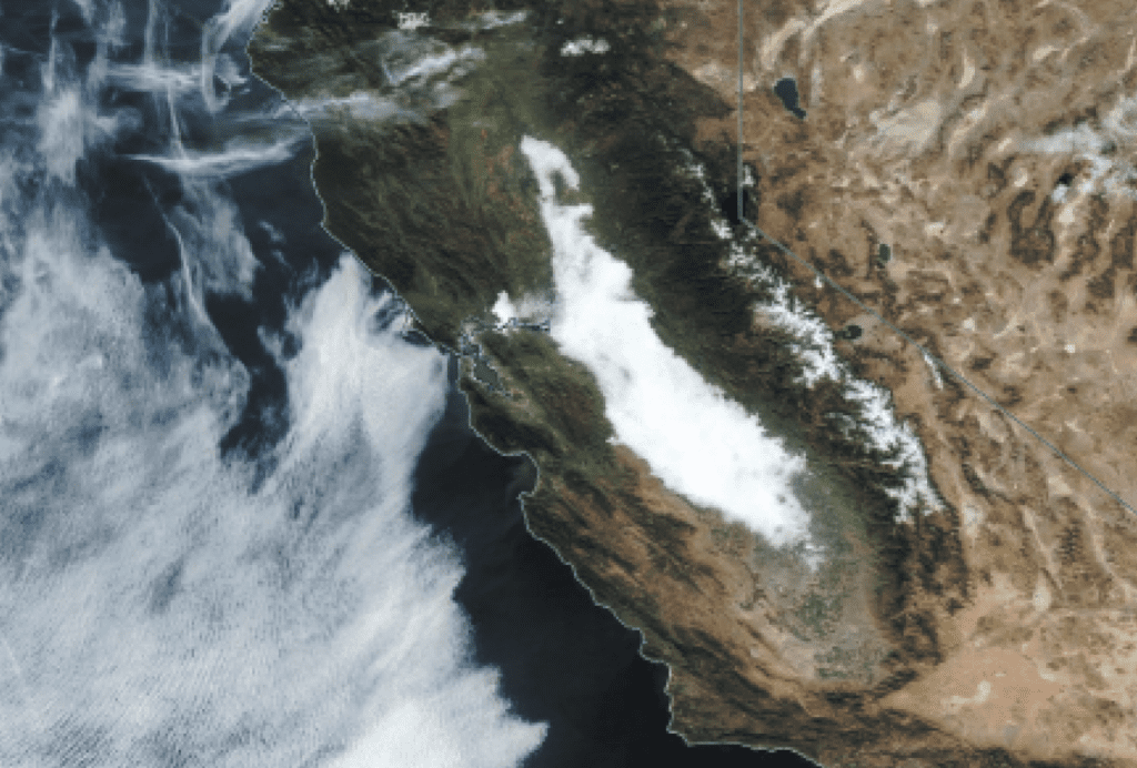
Meanwhile, the strong heating in the inland regions of California causes the Pacific air mass, the “marine layer” to surge inland on summer afternoons in the form of a sea breeze. This flows through straits like the Golden Gate, and across coastal plains like the Los Angeles valley. This marine layer often brings stratocumulus and fog, with reduced visibilities and ceilings. These can persist overnight and not burn off until morning, so make sure you have alternate destinations further inland when flying into coastal airports at night.
Autumn Weather
As conditions begin cooling, the Southwest monsoon diminishes, and the prevailing westerly flow takes over. As the jet stream is normally well to the north, September through November brings some of the best flying weather to the western states.
Transitioning from October to November, the jet stream becomes more active in the Pacific Northwest, and we see weather systems from far out in the Pacific reaching the West Coast. With deep upper-level troughs, both the jet stream and the surface systems will affect the California coast.
Most of these frontal lows bring atmospheric rivers, which become increasingly important in autumn. Also known as ARs or simply as the “Pineapple Express,” these are large plumes of moisture originating from tropical latitudes, normally extending just ahead (east) of the frontal low. They’re called atmospheric rivers because in terms of mass, a large AR event transports water at the same rate as the Amazon River.
The majority of the water vapor transport occurs between 10,000 and 20,000 feet MSL, which means these layers will typically be socked in with broken and overcast clouds, and capped by sheets of cirrus. Lower levels may remain cloud free, but can become filled with nimbostratus and rain where they cross frontal boundaries or a mountain range.
Winter Weather
During the winter, Pacific sea surface temperatures off California are in the 50s and coastal regions often warm to the 60s. This is close to the daily average temperatures found in Arizona and Nevada, so on average the weather remains rather calm.
Weather is dominated mostly by the approach of powerful Pacific systems from the west. With upper-level ridging these may be absent for weeks at a time, but at other times bad weather alternates with a day or two of good weather. These strong weather systems can occur anytime between October and April. From January to March these weather systems often pass south of the Sierra Nevadas, bringing heavy snows to the Great Basin and Rockies.
Canadian air doesn’t often affect the southwest United States, but when intense cold waves develop, the polar air either builds southward from British Columbia, Washington, and Oregon, or it originates from the Great Plains and builds southwestward over the Rockies. When this happens, the cold desert air becomes established over plateau regions of the Great Basin and western Rocky Mountain valleys, and is maintained by powerful nighttime radiational cooling.
This produces a strong temperature differential that sets a persistent, cold foehn wind into motion. Winds turn to the northeast, and LAX begins landing on Runways 6 and 7, left and right, and Las Vegas on 1 left and right. When these winds are exceptionally strong they produce gusty Santa Ana winds that cause fire conditions east of Los Angeles and San Diego. As this air is undergoing a bottom-up modification due to heat conduction and convection, you can expect low-level mechanical turbulence in this kind of pattern.
Spring Weather
In spring, weather in the southwest improves, but strong Pacific systems still continue to pass through the region. Although snow and IMC are less of a problem, these springtime weather systems come with strong pressure gradients and powerful jet stream winds, producing extensive CAT and low-level wind shear. Dust storms from strong gusty winds can be a problem, especially in New Mexico and the Great Plains adjacent to the Rocky Mountains. These regions east of the Rocky Mountains frequently get powerful thunderstorms as moisture interacts with the frontal systems. Further west though, your main problems will focus on turbulence, icing, and IMC.
Spring brings the return of strong summer heating. The procession of Pacific weather systems sharply decline during the month of May, and the dry months of early summer take over.
Drought and Fires
Data from the National Drought Mitigation Center shows that since 2000 a widespread drought was in place somewhere in the southwestern states about 95 percent of the time. As this is written in early summer 2022, large areas of central California, southern Nevada, and most of New Mexico were all in an “exceptional drought” category, and all locations west of the Rockies were experiencing some degree of drought, except in Washington State.
The loss of soil and vegetation moisture, combined with anomalously low relative humidity during drought events, combines to raise the wildfire risk. Wildfire danger in the western states closely follows the month-to-month temperature trend, with July bringing the highest threat. And of course it’s not only smoke you need to watch out for but also the TFRs for firefighting operations. These are getting quite common, so if your weather briefer hasn’t mentioned a TFR, ask them to check the route.
Rapid snowmelt and moisture loss is also bringing wildfire elements up to higher elevations. Historically, large wildfires have occurred mostly in foothill regions and valleys, but climate change is already beginning to produce large fires deep within mountain ranges and on high slopes. A prominent example is the Cameron Peak wildfire in Colorado, which burned at 12,000 feet and crossed the Continental Divide.
All of this leads to more encounters with smoke when flying out west than in years past. When you’re flying through these areas, it’s especially important to maintain situational awareness of your position relative to the terrain, monitor the trend of your inflight visibility, follow the VFR visibility requirements, and be prepared to turn back if the smoke and haze gets too thick. And don’t forget PIREPs. Satellite coverage doesn’t penetrate down into smoke, and smoke doesn’t show up on radar unless it’s carrying soot. This is a situation where a PIREP can really fill in the blind spots about what’s happening.


