
Since the dawn of aviation, icing has emerged as one of the great hazards of flying. The 1994 American Eagle crash in Roselawn, Indiana, shows that this problem has dogged aviation well into the modern era and called the bluff of even trained and experienced pilots. Even in the 2000s, when numerical forecasting had become a mature science, icing was forecast mostly by rule of thumb and experience. Only recently have numerical forecast models begun rising to the task of capturing this sometimes elusive phenomenon.
In the United States, icing is common in winter. But it’s not just a form of winter weather. It’s a global phenomenon that appears at all times of the year. Even in summer storms we find icing levels. We need only to go up high enough where it’s below freezing and there’s enough moisture. The 2009 crash of Air France A330, which disappeared into the sea near the equatorial Atlantic due to blocked pitot tubes and disorientation, is a prominent example of the unpredictable trouble icing can bring.
One pervasive problem is the mindset that icing just affects the wings. Use the boots and they knock it right off, right? But ice also builds on the propellers, reducing thrust, while the unbalanced loads accelerate mechanical wear. Icing also clogs pitot tubes, blocks the carburetor, covers antennas, jams control surfaces, coats the windscreen, and breaks things on the airplane. It’s bad news, and every effort you make this winter should be geared to staying out of icing layers.
A simple way to understand icing and stay safe is to read the assortment of training materials that exist out there. But in Wx Smarts we assume that readers want a stronger immersion in the topic. To understand icing beyond simple bullet points, we need to have a solid grasp of the basics of cloud water and precipitation formation.
Meet Supercooled Water
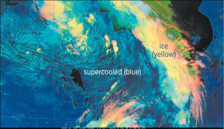
It might seem counterintuitive that ice crystals aren’t what produce most aircraft icing. Ice crystals tend to bounce right off cold surfaces. To coat the airframe, the atmosphere needs to somehow freeze liquid onto the surface. Rather inconveniently, the atmosphere also offers the most unfortunate possible solution: subfreezing water droplets waiting around to freeze on something. We call this supercooled water.
In short, stable liquid water droplets can exist at temperatures between 0-degrees C and the -30-degrees C range. They’re actually very important in meteorology and make up the vast majority of low and middle clouds in the United States during the cold season.
Supercooled water exists because water can’t easily freeze without a nucleus or seed crystal. Suitable particles called ice nuclei do exist, but they must have the right solubility, texture, and chemical composition. Supercooled water is very picky. Generally only about one in a million supercooled droplets floating around in a cloud will be able to pair up with an ice nucleus. That leaves a lot of ‘em waiting for your aircraft.
If temperatures are extremely cold, below -36-degrees C, the water can freeze spontaneously, called homogenous nucleation. No nucleus or seed crystal is needed at these temperatures.
If conditions deteriorate, supercooled droplets will either grow and fall out of the cloud as rain, or gradually convert to ice via the Bergeron cold rain process once some of the droplets find ice nuclei. Whatever the case, there’s going to be a lot of supercooled water in the cloud, waiting to freeze. An amazing nucleation particle is actually your airplane! We’ll get to that in a bit.
Water Vapor and Droplets
Next, let’s look at how moisture gets there in the first place. When meteorologists talk about moisture, they refer to the amount of water contained in the air. Clouds and precipitation make up some of it, but the bulk of it is gaseous, invisible water vapor. Most of this moisture originates from warm oceans and lakes, but quite a bit also comes from evapotranspiration from woodlands, fields, and even irrigated land.
When enough moisture and enough lift are present, and the relative humidity is high enough, we get a phase change from gas to liquid called condensation. A microscopic liquid cloud droplet is produced—the building block of visible moisture. Here’s where the fledgling droplet begins its journey to becoming a block of ice on the wing.
These microscopic cloud droplets form most of the low and middle cloud layers we see. But cloud droplets alone aren’t very effective at producing significant icing. These droplets also can’t grow any further by themselves. To really have an impact on a flight plan, we need the cloud droplets to grow.
Collision and Coalescence
Let’s look at the simplest method of droplet growth in a cloud: collision and coalescence. When there’s turbulent motion in a cloud, some of the cloud droplets will collide with one another, forming larger droplets. If we can multiply the numbers of cloud droplets through continued lift and cooling, our chances of collision increase significantly.
As with any matter that exists in mid-air, objects have a terminal velocity that corresponds to size and mass. This is a speed at which downward gravity force and drag force are in equilibrium. Take the example of a falling ant and a falling elephant. An ant has almost no mass and a slow terminal velocity, so it lands on the ground unscathed, while an elephant lands at a much faster speed, and its days at the circus are finished.
It works the same way with water droplets. The larger droplets have a faster terminal velocity, while the smaller droplets have a slower one. This creates a velocity differential that increases the rate of impact with one another, allowing big drops to more efficiently “swallow up” small droplets as they fall.
When collision results in the merger of drops, we have coalescence. Nearly all collisions result in coalescence, so the words usually go hand in hand. The result is a growing droplet.
Ice crystals can grow the same way in a process called aggregation, which is common with snow. This happens when ice crystals collide and attach to one another. Ice crystals can collect small water droplets, called accretion or riming, and this is key in hail and graupel formation. All of these are collision processes.
But, let’s talk strictly about liquid droplets. Coalescence is by far the most important precipitation growth process in clouds with temperatures above -15-degrees C. The smallest cloud droplets measure about 10 to 20 microns in diameter and have a terminal velocity of about one centimeter per second. It takes almost a day for these droplets to fall out of a cloud. This is so slow that the large-scale ascent dominates, and the droplets never really fall out of the cloud.
As collision and coalescence work their magic, the droplets begin growing. Now we’re reaching the range of supercooled large droplets (SLD), a category of droplets that are 40 microns or larger. This size specifically excludes cloud droplets and covers the range of liquid from small drizzle droplets up to rain droplets. It’s the “important stuff.” Instead of flowing over the wing with the surrounding air, SLDs have enough momentum to impact the airplane. They also have enough thermal mass to spread over the wings before freezing, a process called runback.
If there’s enough coalescence, SLDs will soon grow to around 200 microns, or 0.2 mm—about the size of drizzle droplets—with a terminal velocity of 0.5 meters per second. A drizzle droplet like this falling out of a 500 meter stratus base will reach the ground in about 17 minutes.
Further coalescence allows the droplets to grow to raindrop size, which is about 2-4 mm, and fall about 5 to 10 meters per second. These droplets rapidly grow through coalescence and reach the ground from the same cloud base in only two to three minutes, and it all ends with a large splat on your windshield. Coalescence can still take place during this long descent, but beyond about five mm the wind tends to shred the drop into smaller pieces. These raindrops comprise the upper limit of SLD size.
Supercooled Water
Once we’ve grown supercooled droplets, we have the ideal conditions for significant icing. Not much more is required. When your airplane comes along, these droplets impact your aircraft and coat it, and the icing problems begin.
The production of precipitation affects how severe the icing is. If precipitation occurs, the supercooled water is removed or deposited onto ice crystals and carried to the ground, out of the picture. So if we were looking to create a bad icing situation, we want strong lift and ascent, but not enough where extensive precipitation develops or the droplets get too large. The exception is rain falling into a cold layer below. That produces freezing rain and almost always severe icing.
Theoretically precipitation acts to reduce the icing threat by scavenging SLDs and moving the water to the ground. There are rules of thumb that suggest surface precipitation is linked with a reduced threat of heavy icing. Some research however shows that this is not necessarily the case. This may be due to continued production of a favorable environment for SLDs by the weather pattern, even as the cloud precipitates. We will probably see more research on this topic in the years ahead.
A Recipe for Glaze
Overall, icing severity is controlled by the total available liquid water content (LWC) in the cloud, the temperature, and droplet size. You won’t find predictions of droplet size on Internet charts, but convective (cumuliform) clouds and nimbostratus are the best producers of high LWC amounts. This means watch out around embedded storms and wherever instability values are significant (a Convective Available Potential Energy of 200-400 J/kg or higher in the winter).
By LWC, we mean the density of liquid moisture in a volume, meaning supercooled LWC if it’s below freezing. More LWC means more potential to grow large droplets. This makes LWC closely linked to icing severity. LWC is measured in grams per cubic meter. Some basic ranges you might see on icing charts are 0.1 to 0.6 g/m3 for light icing, 0.6 to 1.2 g/m3 for moderate icing, and above 1.2 g/m3 for severe icing.
Then there’s temperature. Since the 1930s, temperature has served as the most widely used benchmark of what kind of icing to expect. Icing as a whole spans the range of 0 to -40-degres C. At temperatures above freezing, you won’t get structural icing unless the airframe is cold-soaked. At temperatures below -40ÅãC, icing risk is minimized due to the exceptionally low LWC and the prevalence of non-stick rime icing.
The most severe icing is found within the range of 0 to -12-degrees C, which favors clear icing. This type of icing freezes slowly, expelling most of the microscoping air droplets which would otherwise form the milky appearance of rime icing, and it sticks strongly to surfaces. If temperatures are in that favorable range, you only need to look at cloud types and weather patterns, which give an idea of what LWCs are involved.
Closing Tips
Now that you understand icing a little better, I want to give one word of caution. Be careful with freezing level products. First, these charts are automatically generated by computer analysis, and weird temperature profiles and data gaps will create errors. Second, there are sometimes multiple freezing levels near strong frontal systems, and freezing level data fails to take into account the effect of elevated warm layers. All of this can create a misleading picture of what’s really happening. Your best bet is to use tools that let you visualize a vertical cross section along your flight route, and look at the temperature values. The Aviation Weather Center flight path tool is one such option.
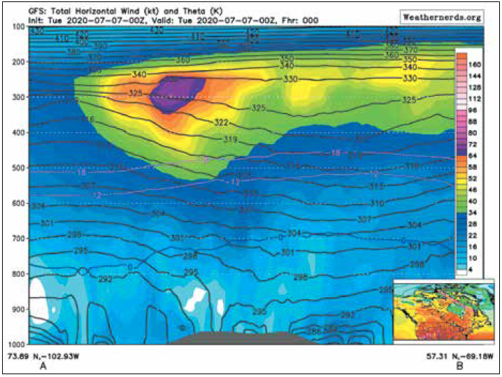
If time permits and you have the interest, you can also review Skew-T soundings, as we’ve shown previously. Soundings are the go-to product for aviation forecasters. Model forecast soundings, like those on PivotalWeather. com, are highly useful, and sites like Weathernerds.org offer vertical crosssection tools for models where you can view forecast temperature fields along a route. While we don’t advise pilots make go/no-go decisions with them, they’re incredibly useful in helping to build a coherent mental picture of what exactly is happening and how everything interacts.
Finally, don’t forget the SIGMETs, PIREPs, and official icing products from sites like aviationweather.gov, and the content from a qualified weather briefing. These, of course, should be the final word when it comes to a flight planning decision. The fancy tools and your knowledge of icing, hopefully, will fill in the remaining blanks.


