
Just one day is all it took for the weather at Dalton, Georgia, KDNN, to go from sunny skies to cloudy and grey. But with higher freezing levels still allowing for cross-countries of modest length, you decided to stick with your plan to fly 211 miles from Louisville, Kentucky, to Dalton. There, you’ll visit a relative and maybe pop up to Chattanooga on the way back.
Great—an LPV
The flight will take about 90 minutes in your club-owned Cessna 172, which had a recent avionics upgrade to include a new GPS (finally) and digital CDI. The catch is the autopilot installation has been delayed for several weeks while awaiting parts. Fortunately, you’ve gotten quite good at hand-flying full ILS and localizer approaches with the old panel over the last couple of years. So flying IFR this way with rock-solid RNAV approaches will actually be easier. (And yes, you were smart enough to practice these ahead of time.)
Now, you relish flying the LPV approach at KDNN. Minimums for Runway 14 are: DA 959 feet, visibility ¾ mile. It’s a basic T-course with an inbound course of 140 degrees at ROLTE, then EWADA for glidepath intercept. There’s a good chance of breaking out at the forecasted ceiling of 600 feet, offering a comfortable margin above DA. Visibility forecast is two miles, with reasonably clear air down lower—not ideal but well above the requisite ¾ mile.
It’s a good plan, so why bother looking at the less desirable LNAV approach? That little voice over the other shoulder says this stuff could someday be relevant, even if not today as many airports have LNAV-only approaches. So review the briefing boxes and see: “Inop table does not apply to LPV.”
Okay, where’s that? A quick search shows the Inoperative Components Table appears in every Terminal Procedures Publication, which, by the way, is updated every 56 days. Is yours? Many items within are also published in the heftier Chart Users Guide. The TPP is more navigable and has approach charts for backup. So TPP it is. Better download it.
Match the relevant approach type and minimums in the inop table’s list, which refers to approach lighting. For KDNN RNAV 14, there’s a MALSR (Medium Intensity Approach Lighting System With Runway Alignment Indicator Lights). If inop, it would mean an increased visibility minimum by ½ a mile, according to the table. That is, unless “amended by notes on the approach chart.” Aha! So no change if using the LPV. If using the LNAV, it would increase from the same ¾ mile to 1¼ mile. Not likely you’ll be required to use the LNAV and have approach lights blink out, but now you know to cross-check any Inop table notes.
Or Not
Don’t close that TPP yet, though, ’til you get the rest of the story on Dalton’s runway lighting. Approach notes include MALSR with the symbol to confirm there’s pilot-controlled lighting. And under MALSR, it says: “Same light configuration as SSALR.” That’s two boxes up on the legend; it’s the the Simplified Short Approach Lighting System, total length of 2400/3000 feet. However, the Runway 14 system is only 1400 feet, and turns on when weather’s below 1000 feet and/or 3 SM. You’d only know this if you dig even deeper for the runway remarks.
After noting that and downloading the additional documents, you’re on to a flight briefing that indicates a smooth flight on top of the 4000-foot overcast. However, the NOTAMs show the approach lighting at Dalton is, indeed, inoperative for two days of maintenance. No problem; you’re arriving in daylight, and flying the LPV. The weather is above mins anyway.
Two hours later, you’re cruising at 5000 feet and enjoying the color moving map. Better yet, ATC issues a clearance 20 miles north of Dalton to go direct ROLTE for the straight-in approach. That means you get to skip the base-to-final intermediate segment as well as the dreaded hold-in-lieu-of-procedure turn.
All’s quiet until just past ROLTE and leveling off at 2600 feet, when the GPS flashes a signal-integrity message and instead of LPV, you’re getting LNAV. Seems you’ve lost WAAS. Probably due to an avionics glitch rather than the rare signal breakdown. No matter now. Can you still fly the downgraded approach?
Fresh out of a review of the aircraft’s Flight Manual Supplement, you know that if outside the FAF and with suitable weather, a reversion to LNAV is an option if the navigator hasn’t displayed an “Abort Approach” message, which would happen if the GPS accuracy degrades below requirements. So you’re down to LNAV mins, here 1160- ¾, and so it’s still feasible and the visibility is the same as the LPV. But just in case, you brief the missed again: “Climb to 4500 direct ONUTE and hold, continue climb-in-hold to 4500.” Now, you’re just about at EWADA and it’s looking good.
Now decide: What’s best for seeing the runway and achieving required visibility? Descend as soon as possible to the MDA, perhaps at the visual descent point 1.2 miles out, then level off ’til you see enough (or miss), or estimate a constant descent rate to meet MDA at the missed approach point? Remember that the profile view only shows a Missed Approach Waypoint for the LPV (here just before the runway) and the LNAV will miss at the runway threshold.
Seeing Enough
The ceiling’s workable yet, but that’s just part of the picture. There’s the little matter of §91.175 (c)(2) that says you can’t land unless “the flight visibility is not less than the visibility prescribed in the standard instrument approach being used…” Now, “flight visibility” won’t necessarily match what’s reported on a METAR or ASOS. In fact, KDNN’s AWOS is now saying it’s one mile in mist, well below the expected two miles and just short of the new requirement. Must you abort just based on that? Not if you can determine flight visibility, defined in §1.1: “… the average forward horizontal distance, from the cockpit of an aircraft in flight, at which prominent unlighted objects may be seen and identified by day and prominent lighted objects may be seen and identified by night.” So for the “prescribed” ¾ mile: Oh, wait. That NOTAM just kicked in and now it’ll be 1¼ mile for the LNAV.
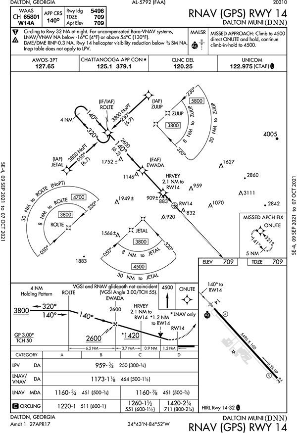
Since you did the homework and know that Runway 14’s MALSR has a rabbit, decision bar and lead-in lights 1400 feet long, you know that’s just over ¼ mile visibility. Now, before you pass by the lights, if you can see both the MALSR (unlit) and the 1000-foot Runway 14 markings, you’re up to 2400 feet, just short of ½ mile. The 5496-foot precision runway does have three sets of 500-foot markings on both ends. If you can see the MALSR, plus all the markings, that’ll just make the 6600 feet—1¼ SM.
Time to go for the MDA. You want a reasonable descent rate and prefer it not to exceed 600 feet per minute. To see if it’ll work, there’s more mental math (cheat sheet in the Instrument Procedures Handbook): “To determine the required rate of descent, subtract the TDZE from the FAF altitude and divide this by the time inbound.” It’s 5.8 NM between the FAF and the runway with 1891 feet of descent; at 90 knots, that’s 3.9 minutes, requiring 498 FPM. Now, since you prefer to descend from 2600 to the MDA of 1160 and be there at least a mile out, that requires about 450 FPM, which you round to 500 for a realistic target. This was a good choice, as you break out where you planned and see the approach lighting plus the full runway markings, giving you a few spare seconds to add more flaps and transition your brain to VMC mode.
Granted, visibility is difficult to calculate while hand-flying an approach, even in a slower aircraft. But knowing how to quickly gauge one mile using what you see in the windshield can be enough to work with on most approaches. Want more margin? Just take the highest mins provided in any given approach, like circling LNAV, round it to the nearest whole number, and use this for planning. If the possibility of “inop” events have you craving additional cushion, tailor those limits as needed to ensure you’ll have more than what’s required for a safe and legal arrival, even if weather or equipment go down.


