
Expect vigorous debate on how best to orient your moving map. Here, I’ll address that debate about the best orientation. But rather than reiterating all the opinions, I’ll focus on what the published scientific research completed in the 1980s and 1990s had to say on that specific question.
Life Before Moving Maps
Remember the old days before moving maps in the cockpit? Navigation was a chore, triangulating one’s position with two VOR receivers (heaven forbid if there was only one) or an ADF. Pilots could only get a general approximation of their position. In those seemingly antediluvian days, the NTSB accident database was littered with accidents in which the crew were pretty clueless as to their whereabouts, notably the infamous 1999 Little Rock, Arkansas, accident of an American Airlines MD 82 trying to skirt a thunderstorm. The captain, having lost situational awareness, was recorded on the CVR saying “I hate droning around visual at night without having some clue where I am.”
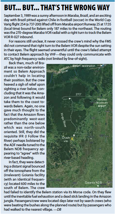
But my vote for the accident that takes the prize for loss of situational awareness goes to the crew of Varig Flight 254 in Brazil in 1989. The downed aircraft was found lying in the Amazon jungle along a reciprocal course to the intended flight route. (See the sidebar.)
Moving Maps Improve Safety
Fortunately, those days are long gone. One glance at the moving map and—presto!—the pilot knows the exact position without so much as a centered CDI needle. This greatly enhances safety. Research has shown that one’s navigational workload competes with limited working cognitive resources needed for concurrent tasks. We can only think of one thing at a time. This means we have to swap our attention between different tasks, which becomes even more challenging the more complex and the more unrelated the parallel task is. This is especially true for single-pilot IFR operations where we maintain course and altitude, navigate, and communicate. Moving maps allow us to focus more on flying and using our limited mental resources to stay ahead of the aircraft.
Moving Map Foibles
Okay, moving maps are a boon. One big question is whether configuring that map in a north-up or track-up orientation is better. Or does it even matter? Pilots have strong opinions on the subject. Indeed, more than a few experienced instrument pilots have foisted their opinion on other equally experienced aviators. Our esteemed editor, who prefers north-up, recalls a proficiency flight with an instructor who, without asking, simply said “let me fix that” and promptly changed the orientation to track-up.
But at the end of the day, pilot opinions are just, well, opinions. However, there is a bevy of research studies on the subject harking back to the 1980s. I donned my scientific researcher hat and waded through this literature. Here, I’ll summarize some of the findings and conclusions putting it into common parlance for the instrument pilot.
Situational Awareness
Let’s first discuss two generic types of tasks pilots need for any IFR flight. First, is “local guidance” which involves staying on a desired navigational path via a series of route “fixes” as spelled out in our clearance. You fly to a waypoint after which a left or right turn might be required to point the nose at the next fix. In this case, it could be argued that a “track-up” (or in scientific parlance, an “egocentric” frame of reference) might meet the pilot’s needs in its simplicity of left versus right. In fact, this is congruent with our natural forward view of the world. Conversely, that same task could get more complicated with a “north-up” map orientation since the pilot has to mentally rotate the map to align it with the forward view of the heading.
The second type of task that we commonly encounter on an instrument flight, differs. Such tasks require knowing where things are in space with respect to a fixed coordinate system (“world-referenced” in the academic world). For example, where are we at a point in time? Or, where are we relative to such-and-such an airport, or navaid? These tasks require “global awareness” and depend on our world-referenced knowledge.
Consider the dreaded hold that is defined with radials from a fix (i.e. world-referenced) oriented from north (360 degrees) through east (90 degrees), south (180 degrees) etc. in a fixed coordinate system. For example, we might be instructed to hold at the CVO VOR 300-degree radial with left turns. Thus, the north-up orientation could prove of greater utility in aiding the pilot entering/flying the hold.
I’ll throw in another example. You’re flying into Big City airport configured with multiple runways. It’s a nice sunny day and TRACON advises a visual approach but then gives you the scenic route around Big City to squeeze you in between the heavy iron (yup, been there, done that). After multiple vectors one has to figure out where the airport is and, more importantly, on which piece of pavement to line up. A track-up orientation will likely require more head-scratching as the pilot has to again rotate the map to make the world-reference (runway diagram) congruent with what lies in front. Okay, I know that the track-up pilot could easily use his bearing-to field coupled with the tail of the HSI needle to figure this out, but remember that many (perhaps too many) pilots are dependent on their moving map.
But that’s all conjecture. What did the research studies say with respect to map orientation?
Study Methodology
Remember, there’s little place in scientific endeavors for anecdotes and opinions. The key to drawing strong conclusions is to compare groups (say 10-40) of human subjects using some predefined measures and seeing if differences are statistically significant. These past studies commonly projected north-up/track-up objects/maps or flight simulations onto a computer screen and assessed subjects using metrics such as response times to complete a particular task and correct/incorrect answers to multiple-choice questions. Common questions were “Where are you?” “which way is north?” or “where is the runway?”
 Is There a Winner?
There were many studies. Space—and fear of boring you with scientific minutia—precludes me getting into detail but I’ll summarize a few findings. Let’s start with a study from 1971 pertinent to following an assigned instrument flight route. The researchers found that the time it took for subjects to compare two visual images increased progressively with the increasing angular difference between images. That is, if images were presented in which the forward view was north for both a north-up and a track-up orientation, response times in comparing the two images were pretty much identical. However, when the image in the north-up display was rotated away from north the time required for comparison steadily rose.
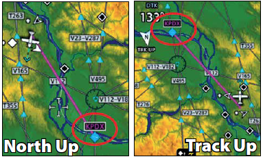
Later studies also noted that errors (in the multiple-choice questions) went up too. If the aircraft (aka subject) is heading other than north, the subject must mentally rotate the map to congruence. These mental gymnastics are not required with a track-up map. Also, the mental resources used for rotating images interfered with flying the aircraft. Pilots using a north-up map for southbound legs had more vertical excursions than aviators using a track-up orientation. These studies would favor track-up to follow a planned route.
So then, did these findings write off north-up for pilots who configure their moving maps this way? Nope. The situation changes when one is performing navigational tasks requiring a world-reference. In one study in 1989, helicopter pilots flying a sim with an electronic map with a north-up did better in positioning objects on a map (in the instrument world that could be a navaid, an airport etc.) than pilots with a track-up display. That wasn’t a one-off study. In another study published six years later pilots were tasked with flying a simulated MLS approach (remember them?) in IMC through a terrain-filled area. Again a north-up orientation proved superior in locating world-referenced geographical features, i.e. what is the compass heading to such-and-such. This would imply that situational awareness-related questions/tasks that we, as pilots commonly encounter (where is the airport, navaid, waypoint?) are better addressed with north-up.
Drawing some Conclusions.
Taking the published literature as an aggregate (and certainly the view of one of the leading investigators in the field—Dr. Chris Wickens, University of Illinois), the data generally support the view that a rotating (i.e. ego-referenced aka track-up) moving map is superior for the pilot following an assigned routing as we do for any flight. The reason is simple: The left-right guidance obviates the need for the pilot having to mentally rotate a map. On the other hand, the world-referenced system (north-up orientation) is better suited for situational awareness tasks.
Ultimately, though, one has to decide to use one or the other. To quote Dr. Wickens presenting at the Advisory Group for Aerospace Research and Development symposium in 1996 “…if a single display were to be available to serve all tasks, (i.e. both guidance and situation awareness) with greatest benefits and fewest (mental) costs, then map rotation (i.e. track-up) should be the display of choice, although we would strongly advocate the availability of fixed map options.”
Study Limitations
All research studies have their limitations. Here, the projection of simple images or very rudimentary “electronic maps” per the technology at the time (two studies used IBM AT computers) are far removed from today’s moving maps. Another shortcoming was that some subjects in the experiments were non-pilots or not instrument rated. These individuals would not be tuned to the intricacies of the instrument environment.
Last, a key question that could not be answered back then, was whether pilots who configure their moving map in a track-up orientation perform just as well on in-flight path/situation awareness tasks as those configuring theirs in a north-up orientation. Perhaps I’ll set up a GoFundMe website to explore this question.


This article completely validates the way I’ve configured my cockpit for a long time. My MFD is configured for track-up for navigation, and my iPad is set to North Up for situational awareness.
I’m fly a similar setup most of the time, Chris. The MFD being track up because “back in the day” I flew a lot of low level mission when left or right was more important of a command. But more often than not, I fall back on north up when flying instrument approaches.
My wife will appreciate this article. She drives her car with the map track up, I drive with North up. I’ve been unable to convince her to change. However in the air, enroute, I use North up as if using an old paper chart . But on an instrument approach I switch to track up for better situational awareness.
Track up is much better when traffic is displayed on the map. Traffic appears in the correct relative position.
I used to be a track-up guy until one day……..flying into a busy St. John’s, Newfoundland airport, there a big mix-up and a frantic controller yelled “ALL aircraft head east and stay east of the airfield NOW”. It took me a couple of seconds to figure out the best heading and which way to turn. I’ve been North-up guy since that day.
I strongly prefer TRACK UP for panel mounted display, oriented with whats outside the windscreen, and NORTH UP for a screen in my lap for big picture awareness. Corresponds to orienting with the HSI vs paper chart in lap. I’m not too sharp and this works great for me. Remember richard Collins saying he was a TRACK UP MAN for his panel display and I followed suit..
When we got our first moving map in the panel I was strictly North Up since I was used to North Up charts in my lap. Years later, when adding an iPad on the yoke, I changed the panel map to Track Up, but I keep the iPad on North Up.
Switching between N up and track up is one touch on Foreflight screen. I use both, but prefer track up, switching to N up when needed.
This brings up an interesting question: Is there any easy way to configure hotkeys on the common glass panels to readily switch? (I’m thinking of the G1000 here; just purchased an airplane with one but haven’t taken delivery and got used to it yet).
I think the “keep your iPad North Up” is a slick solution, and you can always rotate it to the HSI as one of the above posters said.
I wrote a response to Douglas Boyd’s article re north up vs track up and cannot find it