
While we certainly don’t need to examine weather accidents to remind us that weather can be a killer, reviewing them can be a good teacher. The accidents we’ll review attracted only a couple paragraphs in the local newspaper and were quickly forgotten, but every incident has the potential to save lives. We’ll try to understand their story by digging into radar and weather data and poring through the NTSB archives and try to find just how these pilots got themselves in trouble and what lessons we can learn.
A Terrible Texas Storm
In June 2014 the 61-year old pilot of a Piper PA-46 filed an IFR flight plan from Aspen, Colorado to the dairy town of Brenham, Texas, northwest of Houston. The pilot was an Abilene oilman, who once chaired a Texas energy consortium. He logged 2258 hours of flight time with 188 hours in this aircraft. One of the passengers was a Tennessee native following a dream to be a Colorado cowboy, and the other was described as an avid boater. The 750 NM route would be flown at FL270, taking the aircraft over Alamosa, Colorado; Tucumcari, New Mexico; and Abilene, Texas. Just after 1 p.m. the pilot and his two passengers departed.
An area of storms was in the flight’s path across west Texas and the panhandle region. Even the Storm Prediction Center had concern about the storms, issuing a severe weather Slight Risk advisory and identifying wind and large hail as the primary risks. Forecasters advised that “the potential will exist for supercell and organized multicell morphologies with a risk for damaging winds and large hail.”
Over the dry landscape of Colorado the flight was uneventful, though while passing southeast through Tucumcari the airplane began a series of 400-foot altitude deviations. When queried by Albuquerque Center, the pilot replied that the autopilot was having issues. Southwest of Amarillo, the pilot turned to avoid a storm. The pilot was cleared to deviate east, but he deviated west and worked down the back of a line of storms.
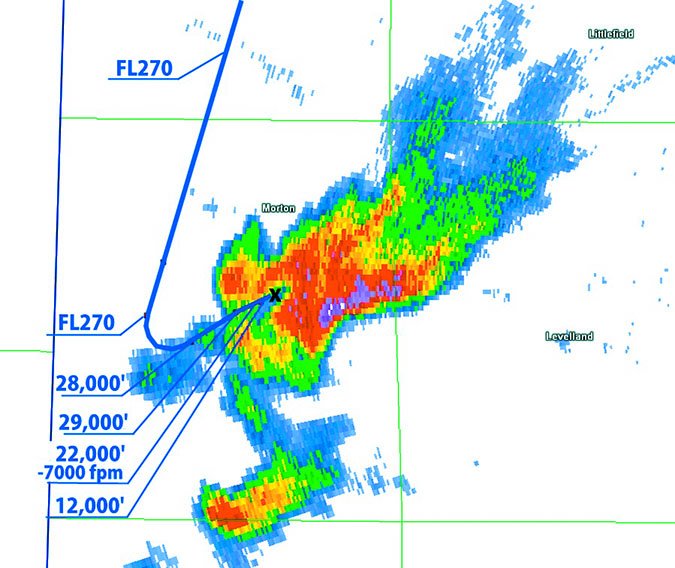
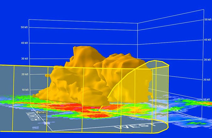
While flying southwest behind one of these storms southwest of Lubbock, he started a left turn (See illustration.) that took him almost directly toward the storm. The Fort Worth controller asked if he was going north to try to avoid weather, but the pilot responded he was “trying to go through a window.” The aircraft began an altitude deviation up to 29,000 feet and ATC asked if he needed the higher level, but there was no response. The controller then warned the pilot he was heading directly into a storm with extreme precipitation.
Shortly afterward, ATC received a mayday call, followed by “nineteen” after a request for altitude. The pilot clarified the distress call, saying he was in a spin. Several aircraft overheard the call and attempted to assist, but there was no reply. Radar and radio contact were lost. The aircraft hit the ground at about 4:33 p.m.
Texas: Aftermath
The aircraft was discovered relatively intact, sitting upright in a pasture. All occupants died on impact. Investigators found the landing gear selector in the down position and flaps at the 20-degree position, suggesting the pilot had been trying to regain control.
However the focus was squarely on the thunderstorms that had moved through the area. A neighbor who lived directly across from the pasture where the plane crashed reported “terrible storms in the area, with strong winds reaching 40 miles per hour and ping pong-sized hail,” and added his family had to pull their car over just about two miles from his home.
About three hours before the crash, the pilot had called Lockheed Martin Flight Services for an abbreviated briefing. No convective advisories were in place over the west Texas region, but the briefer advised the pilot about the dryline pattern over that region with abundant moisture. The pilot acknowledged he was familiar with the setup and knew he would be contending with storms.
My own analysis of the radar signatures indicate this was a strong multicell storm, with a couplet showing broad-scale rotation of 40 knots. A severe thunderstorm warning was in effect for this cell, with 60 mph winds and half-dollar sized hail expected at the ground. The radar cross section (pictured) shows the 43 dBZ surface, corresponding to heavy rain and small hail, and shows the plane was on the edge of strong reflectivity gradients. However, an important finding is that the plane had not reached the area of stronger circulation and intense precipitation, and was not in an intense updraft region. This suggests that the crash was likely caused by a control upset due to extreme shear at cruise altitude. Clear icing on the cold-soaked airframe may have also been a factor, accumulating rapidly between 15,000 and 25,000 feet and reducing the aircraft’s recoverability.
Texas: What We Can Learn
One of the puzzling aspects of this case is that the cells were scattered and radar data showed 15- to 20-mile gaps between the cells. It’s not entirely clear what led the pilot to turn into the most intense cell in a scattered line in an attempt to penetrate it. This appears to be a case where the pilot was attempting to go visual, with his view of gaps partly blocked by cirrus and mid-level cloud debris, and the pilot was probably not availing himself of the full-spectrum of weather data. Indeed the investigators found that the pilot’s iPad was in his luggage, and the report did not identify any multifunction display in the wreckage. It also appears that ATC controllers missed numerous opportunities to help the pilot get through one of these wide gaps between storm cells.
It’s meteorologically significant that the airspeed and altitude upset was well to the rear of the storm, in an area considered by forecasters to be away from the more intense elements in such a storm. This was still in close proximity to a precipitation core, and well within the 20 NM danger zone emphasized by FAA guidelines. But the weak intensities immediately around the airplane serve as a reminder that all areas of a storm are dangerous and attempts to penetrate a storm carry risks that aren’t just limited to extreme turbulence and hail.
It also appears, at least to me, that radar data was remarkably underutilized by all parties involved, and there were many windows available that would have allowed the aircraft to proceed toward a smooth touchdown in Brenham. This accident might not have occurred if the pilot had developed an understanding of his predicament, allowing him to take an active role querying controllers for advice. Controllers have access to the same quality of displays that forecasters have, and this is a case where the information was not forthcoming. Advice from ATC provides a solid source of information and can add valuable information to what pilots are seeing on their displays and outside with their eyes.
Trouble in Missouri
Early on June 14, 2015, the 54-year old pilot of a Piper PA-32, with 1175 hours, took off from Branson, Missouri, headed to the St. Louis area. The pilot was returning to the city from his lake house with only his dog as a passenger. A cluster of weak to moderate thunderstorms were already in progress along the route of flight. The airplane was equipped with a Stormscope WX-10. No tablet or satellite weather devices were on board the plane.
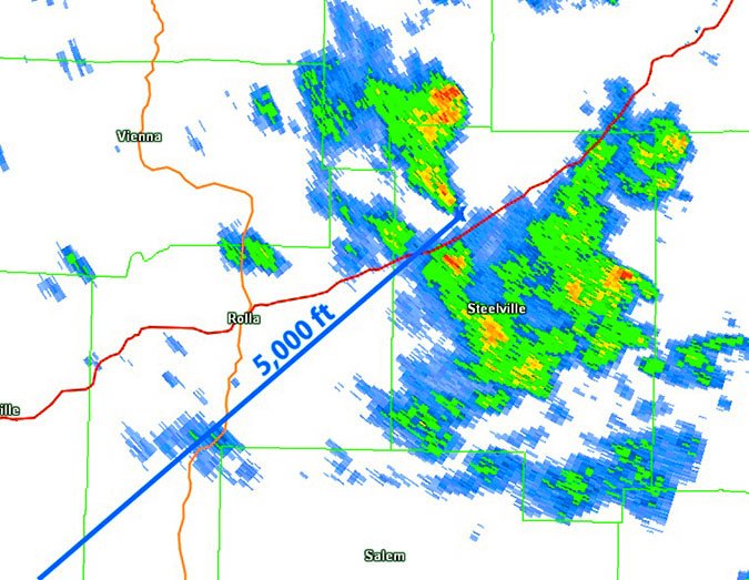
The plane took off at 7:01 a.m. and headed northeast at 5000 feet on an IFR flight plan. Shortly after takeoff, the Kansas City low altitude controller warned the pilot of “moderate to extreme precipitation from your 10 o’clock to your 2 o’clock beginning in 50 miles.” The pilot acknowledged the report and mentioned his ‘scope. The flight proceeded uneventfully until 30 minutes later when ATC lost contact with the plane.
Missouri Aftermath
The wreckage was found scattered in numerous pieces. Investigators combed through the parts and found no obvious mechanical issues. A witness recalled seeing the plane spinning toward the ground with pieces falling off, continuing beyond the tree line, followed by a loud crash. Another witness confirmed this observation, reporting the plane descending through the clouds and noting that a “wing was falling separately along with other parts of the plane.”
It appears the Stormscope fared quite well in keeping the pilot in the gap between the storms. Even if he’d had onboard radar, it’s difficult to see how he would have done much better. A rational course based on the available radar data would bring the plane only a mile further south in the same gap between cells.
This accident appears once again to underscore the danger of storms. Looking at all radar tilts and elevations, as well as the evolution of the storm, there was no flight into significant precipitation. We must bear in mind, and this has been emphasized repeatedly in previous columns, that radar and spherics data cannot reliably identify updrafts.
The updraft is one of the most dangerous parts of the storm. It contains the most violent vertical motion, forms the core of the mesocyclone and tornado in supercells, and is comprised of the cumulonimbus tower itself. The updraft does contain precipitation in the process of developing, but these larger droplets and ice crystals often appear at much higher elevations or are blown downwind in the nearby precipitation cascade. The separation is greatest in severe storms because of the effects of shear and rapid displacement of the growing droplets.
Was the aircraft in the updraft? Further inspection of the radar data indicates yes: low-level shear vectors originated from the south side of the storm, indicating the towers were south of the cells. Instability was not particularly strong, but interpolation between radiosonde readings suggested a pocket of enhanced low-level moisture and moderate instability across eastern Missouri, and this storm cluster was in the process of strengthening.
Barring some sort of other issue like excessive control inputs or dealing with an agitated dog, it appears highly likely that the airplane broke up in a cumulonimbus updraft, and perhaps clipped a small pocket of strong shear or an embedded vortex. With the displayed intensities of these cells in the moderate range, on the order of 41 to 48 dBZ, this emphasizes that even benign-looking cells are a danger. This is a pattern we have seen in previous WX Smarts articles.
Missouri: What We Can Learn
By now it should be abundantly clear that we can get into serious trouble well outside of a hail core or the jaws of a squall line. The NTSB reports on these events do not include the radar data and they all conclude with the same line, citing controlled flight into thunderstorm activity that resulted in loss of control and inflight breakup.
But here we carefully deconstructed the sequence of events from radar track data and the original WSR-88D Level II data files. In both cases, the plane was not in the most dangerous part of the storm at the time and place of the crash. What we’ve learned here is that it’s not enough to just avoid the red colors: even areas peripheral to the storm are dangerous.
The FAA’s publication, Thunderstorms—Don’t Flirt…Skirt ‘Em (FAA-P-8740-12), reminds us to never get closer than five miles to any visible storm with overhanging areas, and encourages increasing that distance to 20 miles or more. The FAA Pilot Handbook of Aeronautical Knowledge (FAA-H-8083-25) warns of vertical currents of over 3000 fpm, and reiterates the five-mile rule.
The only thing to add is that meteorology has an energy equation that relates instability to vertical motion. We know that updraft speeds of 5000 fpm are quite common in the central and east U.S. during the warm season, and I have seen instability levels occasionally that would support breathtakingly dangerous 12,000 fpm updrafts. It’s important to remember that radar doesn’t always give you enough information to see these monstrous updrafts.
Airborne Radar
Speaking of radar, the only good radar data for penetrating storms is airborne radar. It’s highly discouraged to attempt to navigate your way through storms using satellite or Internet radar sources. This is because of ambiguity from data latency and the correlation of intensities to your altitude. And even then, as I’ve pointed out, even a good airborne unit will not detect hazards in updraft regions. At that point, your only protection is lots of mass and thrust, two items often lacking in general aviation.
And if you absolutely must penetrate anyway (Why?) well, I’ll entreat you to stay out of intense radar echoes. You probably know that, but watch out for cells with intense gradients. High intensity favoring one side of a storm and not another is one sign of this. Those areas indicate very strong shear and dangerous hazards like intense updrafts, vortices, and enough shear to rip your wings off.
And be aware of the problems with attenuation of your radar beam. Airborne radar just doesn’t have the penetration capability of the 0.75 megawatt WSR-88D and its better wavelength. Talk to the ATC controller, who has this radar data at his desk and can see your plane. They can give you a good vector that will increase your odds of coming out safe.
We’re entering storm season. Stay safe around those cells; we want you back for another issue.
Tim Vasquez is a professional meteorologist in Palestine, Texas. See his web page and his various materials at weathergraphics.com.


