
Holds are the bane of many pilots’ existence. The variety of helpful and not-so-helpful tips, tricks, and other “aids” tells us how big a problem it is. Fortunately, most of us eventually figure out that published holds are easy. A picture tells a thousand words. Unless we are a little OCD about that 70/20 section, when it’s drawn out for us, all we need do is visualize our path to the holding fix and even the AIM-sanctioned entries become obvious.
Unpublished holds, however, continue to perplex many of us. Fortunately, there are now excellent tools in both certified avionics and our EFBs that allow us to create holds at any waypoint—even a user created one. EFBs will let us draw the hold for situational awareness. The latest panel systems will do that and more; they will give us and our GPSS-enabled autopilots the same steering commands we receive for published holds in the database.
Let’s look at two of these panel systems: the Garmin GTN series and the Avidyne IFD. We will also look at two popular EFBs—ForeFlight and Garmin Pilot—to see how they can provide us great situational awareness regardless of the avionics we are using.
The Hold
There’s no need to make the hold complicated. Once we understand the basics, we can apply our knowledge to more complex situations. We will use an RNAV waypoint in a part of the contiguous U.S. with no airway radials. And, although random holds in real life tend to be inbound on the course the pilot is already flying to the fix, we’ll use a different course to illustrate what these tools can do.
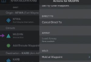
We are en route from Fort Wayne, Indiana (KFWA) to visit family in Ann Arbor, Michigan (KARB). It is a short flight with a simple direct clearance, although we expect vectoring as we approach the Detroit Class B. West of Toledo, Ohio, we are advised that we will need to hold. (Refer to your chart L-28 if you wish.) “Proceed direct MUDHN. Hold west of MUDHN on the 090-degree track inbound, four NM legs. Expect further clearance at 1825Z.” Adding MUDHN to our flight plan and punching “Direct” on our GPS, we proceed toward the waypoint.
Garmin
We’re using a Garmin GTN 750Xi for illustration, but this applies to all modern Garmin navigators that have hold capability. This includes Garmin’s smaller units like the GPS 175. It also includes the most current iterations of its G1000/2000/3000/Perspective Integrated Flight Deck, although the non-graphical flow in those is marginally different. Older G1000s and the GNS 400/500 series do not include the ability to create holding patterns.
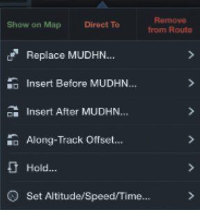
 Tap MUDHN in the flight plan. From the pop-up menu, select “Hold at Waypoint.” The resulting screen contains the default selections, typically a direct entry on the current course with an FAA-standard one minute inbound and right turns.
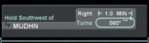
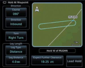
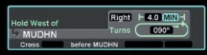
Change the defaults to conform to our clearance. Enter the 090-degree inbound track (note that we can select either inbound or outbound). Change the Leg Type from Time to Distance and enter four NM. We can optionally enter the EFC time to notify us when it is up. The hold we insert is depicted on the screen and, as an additional sanity check, the GTN even parrots the “hold west” part of the instruction.
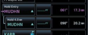
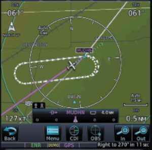
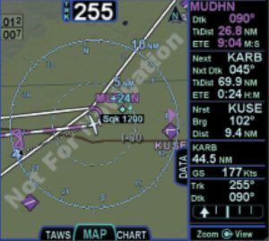
The GTN inserts the hold into our flight plan and draws it on the map. The system will treat it the same as any hold contained in the database, including prompting our entry and turns. Your GPSS autopilot will fly it as depicted.
Avidyne IFD
The Avidyne functionality is identical; the flow is a bit different. Begin on the FMS flight-plan page and select the insert cursor (the thin cyan line) after MUDHN. Choose “Hold at MUDHN” from the selection list. Like the Garmin, the IFD creates a default 1-minute direct-entry holding pattern.
Tap the hold to change to edit mode and conform the default entries to our holding instructions. The IFD, like the GTN, gives us a “hold west” reality check. If we create the flight plan while the FPL Map insert is displayed, we will see the hold painted as we build it. In any case, the completed hold becomes part of our flight plan and is depicted on the map tab.
Using an EFB
What about those of us who are using an older GPS that can’t create random holds? There are many GNS 430s and 530s still in our fleets. The best we can do is use OBS mode to create the inbound leg. That allows us to fly the hold and helps our situational awareness somewhat, but several electronic flight bags (EFB) can give us an additional boost. (This also applies if we have no panel GPS at all and receive a hold at a random VOR or identifiable intersection.)
ForeFlight
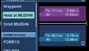
ForeFlight’s Hold Advisor can be accessed in a few ways. Tap on a waypoint on the map or in the flight plan window. The familiar information box includes a “Hold…” option. Similarly, the Procedure Advisor we use to add SIDs, STARs, approaches and traffic patterns to our flight plan now includes a “Hold…” selection. Choosing either brings us to the Hold Advisor. Like the IFR-certified panel units, the Hold Advisor presents us a default standard holding pattern based on our course to the waypoint. Change those to conform to the holding instructions we received and ForeFlight inserts the hold into our flight plan and paints it on the screen.
Garmin Pilot
Garmin Pilot’s hold creation tool can also be accessed by tapping a waypoint on the map. But this method requires switching the map into graphical editing mode. I suspect most pilots will find it more efficient to create the hold from the flight plan. The flight plan can be accessed by pulling it down over the map or switching to the dedicated flight plan page.
From there, the process is substantially the same as what we have already seen and almost identical to Garmin’s panel mount units. Garmin logic, flow, and touchscreen interfaces tend to be consistent through all its offerings. Tapping on MUDHN, we get a menu. Scroll down and select “Hold at Waypoint.” This brings up a dialog similar to the others. Tap on the appropriate selections, change them to our 90-degree inbound, four NM leg, standard holding pattern, and it will be displayed on the map—both the split screen map on the Flight Plan page, and the main Map page.
Is Using an EFB For This Legal?
May we fly a holding pattern created on an EFB? The answer is the same as for a holding pattern one might draw with a pencil on a paper chart. It’s a situational-awareness aid to flight using the primary IFR instruments. We know from the AIM that GPS systems that are not certified for IFR navigation cannot be used as a primary instrument flight-reference. “During IFR operations they may be considered only an aid to situational awareness.”
So, no, we may not build the hold in ForeFlight or Garmin Pilot, switch to the synthetic vision page on our phone or tablet and use that for primary navigation. But drawing a hold on a map, whether using a digital tool or with a crayon on a paper chart, can greatly aid our situational awareness for both hold entry and flight within the hold. So long as we fly the hold based on what our HSI or OBS/DG combo shows, we are doing it correctly.
In fact, from a regulatory (and arguably safety) standpoint, this is what we should be doing with the advanced tools in an IFR-certified GTN or IFD to create a hold. As the GTN AFMS and Pilot Guides tell us “The only approved sources of course guidance are on the external CDI, HSI, or EHSI display. The moving map and CDI depiction on the GTN Xi display are for situational awareness only and are not approved for course guidance.”
Mark Kolber is a CFI and (mostly retired) aviation lawyer who thinks that IFR is sometimes like poker. You need to know when to hold and when to fold.


