
In our last issue, we talked about the building blocks of weather radar—how it was developed, the basics of radio waves, problems with radar sampling, and the important differences between composite and base reflectivity. If you haven’t read that, I highly recommend you do so to get a good grounding in radar fundamentals. In this issue we’ll take that knowledge and teach you a bit about interpretation.
My background is primarily in meteorology and I hold a certification on the NEXRAD radar, so with this grounding in weather radar I can teach you some tricks and techniques to help you make sense of what you’re seeing. I hope this article helps you think like a forecaster so you can adapt to the data available in the cockpit and make decisions that will assure a safe flight. You can also use the information just sitting at home as a storm rolls into your city.
The biggest indicator of storm severity is the environment. What is the character of the atmosphere along the route? Without pre-existing instability or shear in a particular region, there’s no way we can have severe storms, regardless of what the radar indicates. Instability and shear are complex quantities best left to the forecasters, so check products like the Storm Prediction Center convective outlooks (www.spc.noaa.gov) to see what’s happening. Slight, moderate, and high risk areas are reliable indicators of strong instability or shear, and this has a huge bearing on how to interpret radar signatures.
We need to remember that radar detects three primary elements: water droplets, ice crystals, and ice itself. These are large, visible particles. There’s often a lot of water vapor in the atmosphere, sometimes as much as an ounce of water per cubic meter, but we don’t see it on radar because it’s in a gaseous state and reflects almost no energy. Moisture and high dewpoints are associated with lots of water vapor in the atmosphere, so it’s not accurate to say radar detects moisture. It’s better to say that radar detects visible water and ice particles. These often don’t coincide with where the clouds are.
What Radar Detects
Recall that radar sends out a strong, narrow radio beam that reflects off particles in the atmosphere and returns to the antenna. The particles that return the most energy are large targets, especially large raindrops and hailstones. The smaller the “reflectors” are, the less power will be returned to the radar. For example, cloud droplets average only 0.01 millimeter in diameter. The radars produce wavelengths of 5 to 10 centimeters—a tremendous mismatch with the size of cloud droplets—so we don’t see clouds very well on weather radar. Airborne radars operate in the short-wavelength X-band, so they do have some sensitivity to clouds and will occasionally detect towers.
We talk about weather targets “reflecting” radar energy. It’s important to keep in mind this is a simplification. This is okay since we’re not radar engineers and we’re not too concerned with the physics, but let’s take a look at what actually happens. When the radar beam reaches a target, like a rain drop, it induces minute voltages and current in the target. This produces a difference in voltage and current in the drop known as a dipole, with one side of the droplet having positive charge and the other negative charge. This dipole causes the target to act like an antenna and broadcast some of the energy back to the receiver.
If the target is too small, the radar energy is mismatched and the target won’t resonate with the right energy. Think of this like getting on a swing and using the wrong timing. Most playground swing sets have a natural resonance frequency of 3 to 4 seconds as we swing back and forth. If we swing our legs slowly to and fro at a 30-second cycle, the swing will move a little bit, but most of our energy will be wasted, even if we put a lot of power into it. Likewise, if we’re trying to detect microscopic cloud droplets of 0.01 mm with a 3 cm airborne radar, the wavelengths are mismatched and the droplet dipole oscillates with very little energy.
Powerful, sensitive radars like NEXRAD and short wavelength radars like airborne X-band radars, are also efficient at detecting birds, bats, and insects, seen as broad, diffuse patches of low reflectivity in fair weather. Those often make up the bulk of echoes we describe as “ground clutter.”
In general, about 98 percent of the radar energy coming from biological sources is reflected by micro-insects, measuring less than 10 mm. Meteorologists are grateful to these creatures since they often reveal important boundaries and help provide a baseline measurement of velocity in the atmosphere.
High Reflectivity
The best indicator of dangerous weather is, of course, high reflectivity. This is where your radar display is painting large areas of red or magenta, with reflected radar power above 60 dBZ. The cause of high reflectivity is the presence of large rain droplets and especially wet ice particles. Wet hailstones and melting ice particles will also show high intensity levels.
An even more important indicator of dangerous weather is the presence of high reflectivity at high altitudes. Elevated high reflectivity can be easily seen with the “vertical profile” or “VP” modes on airborne radar. If you have tablet based sources or ADS-B and have a little time to look at things, you can compare the lower tilts with the higher tilts, bearing in mind that increasing altitude from ground radar means increasing range.
Elevated high reflectivity is normally associated with high-instability weather regimes and is a sign that a very strong updraft is lofting the precipitation production process to high altitudes. A high-instability environment always means strong updrafts and downdrafts, extensive areas of clear icing, and the potential for powerful circulations in thunderstorm clouds, so when you see high reflectivity at high levels, this means the storm should be given a wide berth.
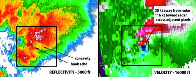
Where it shows elevated reflectivity with weak or no reflectivity in the lower levels, this is a signature known as “overhang,” with the area below known as the “weak echo region” (WER). This is common in severe multicell storms and supercells, and it corresponds to a strong updraft and must be avoided.
Another note about high reflectivity: if you use airborne radar, look for “shadowing” past strong echoes. This indicates attenuation is taking place. The shadows are noticeably aligned with the radar radials. As we’ve discussed, aviation radars are very susceptible to attenuation, where energy is damped when passing through other echoes closer to the airplane, and there’s not enough remaining energy to provide useful information. The longer wavelength radars are much less affected by this, so use NEXRAD (which is a long-wave S-band radar) to help you get an idea of what’s on the other side.
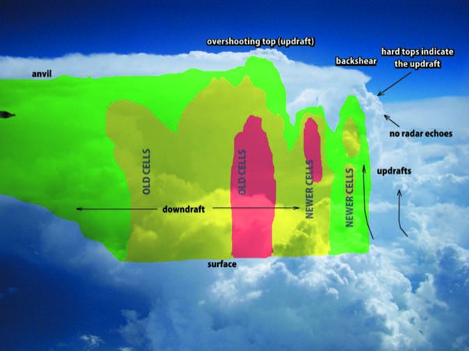
Make full use of airborne radar’s tilt and range settings. Developing thunderstorm cells typically produce the first echoes at about 10,000 to 18,000 feet. At higher altitudes with your radar looking directly toward the horizon, it will overshoot these echoes. Within minutes you will see them expand in size and grow to higher altitudes, potentially dangerously right in front of you. Tilt the radar down a couple of degrees to make sure you’re capturing all of the developing cells ahead of you, to avoid being taken by surprise. Likewise, change the range occasionally to the highest setting to make sure you’re not missing anything down the road.
Patterns
Perhaps the most important pattern-based indicator that you should be alert for is the presence of strong reflectivity gradients on a cell, where there is a transition from low reflectivity or none at all to high reflectivity over a short distance. The side of the storm where you find a persistent reflectivity gradient often indicates the location of the updraft. Not only is such a storm severe, but the updraft contains strong wind shear and high vertical velocities. So avoid storms with high reflectivity gradients and also avoid the adjoining “clear air” where radar returns are weak or not present.
You should also look for unusual concavities in storms, especially when they’re associated with these reflectivity gradients. This is an excellent shear indicator and is typically associated with high-precipitation supercells, quite possibly embedded in a squall line. These concavities are normally associated with the weak echo regions (WER) described above and indicate an intense updraft. In some cases they develop further into a hook, with a tornado on the ground. The vortex with these tornadoes can extend up to the storm top, so steer clear.
Another pattern you sometimes see is the characteristic V-shape or “flying eagle” shape of the supercell storm. These storms often have concavities, reflectivity gradients, weak echo regions, and intense reflectivities. The hook is usually found on the side of the storm where moisture is feeding into the cell. These flying eagle shapes are occasionally seen in the central United States in the spring and fall months with isolated supercell storms.
One more important pattern is simply an isolated cell with no other activity nearby. This indicates there is little competition for moisture. The cell has much more potential to become severe than it would if it was in a line of storms, and in unstable conditions these isolated cells often develop into supercells, consisting of a continuous intense updraft and rotation in the storm. Because of the violent circulations, widespread icing, and potential for large, damaging hail, any intense storm that is isolated or is just north of a large break in a line of storms (in the northern hemisphere) should always be considered to be a significant danger justifying proper avoidance techniques.
Another thing forecasters look for is deviant motion, where one cell has an unusual movement compared to others. Undetectable on airborne radar, some NEXRAD displays allow you to overlay storm tracks, so you can spot deviant movers immediately. These typically contain strong mesocyclones (rotation in the mid-levels of the storm), and you can always assume large hail and the possibility for a tornado vortex in the cloud.
(Doswell/NOAA)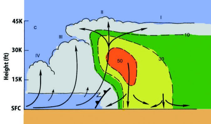
Storm Organization
Large areas of thunderstorms may aggregate into a mesoscale convective system or MCS, essentially the same thing as a squall line. This is a single organized thunderstorm system driven by a large, common outflow pool at the surface. The size of systems is on the order of hundreds of miles, making what we call a mesoscale system, and the strongest part of the MCS is usually where incoming moist low-level flow impinges on the cold pool—typically the southeast periphery. The tail-end storm, sometimes called “Tail-End Charlie” by storm chasers, is often the most intense cell and contains the strongest circulations in an MCS.
Dangerous clear ice and turbulence are still possible in mesoscale convective systems but we typically don’t see the violent circulations present in supercells, because of the competition for moisture that limits the intensity of any one part of the line. They can normally be penetrated without a problem using airborne radar systems. However leading edge vortices can still occur along the gust front, producing gustnadoes or shallow brief tornadoes that are a hazard in the low levels.
If part of the MCS begins bowing forward, this may produce a bow echo, with very strong winds at the ground and intense circulations aloft. The dimension of a bow echo is typically about 10 to 20 miles. Sometimes the entire system forms into one giant bow echo, with a much larger scale, and this can produce broad areas of wind damage at the surface and a much larger hazard to aircraft with violent turbulence aloft.
In closing, I want to remind you that NEXRAD in the cockpit shows old data. Even using PC-based radar analysis tools, it’s difficult to get scans that are newer than 2 to 3 minutes from the time the radar energy comes back to the radar and the time it’s displayed on your screen. With XM Weather and ADS-B, the mosaic building process and congestion of pushing out other products to the data stream can add more minutes to the delay. So these tools should only be used for planning and getting an idea of the size, location, and intensity of storms, not to pick your way through. Getting on the radio and asking ATC for help if you can’t get a handle on things is always a good decision. They have acces to NEXRAD, TDWR and ARSR-4 radars providing an excellent view of the weather around you.
In spite of all these techniques, remember that the best avoidance is proper planning and what you see with your own eyes. Check all the products before takeoff, including the convective outlooks from Storm Prediction Center (www.spc.noaa.gov), and once you’re up in the air, keep a close watch on what you see ahead. Please stay safe!
Meteorologist Tim Vasquez used to brief B-1B crews in the morning. Now he sleeps in and writes books and software. See his website at www.weathergraphics.com.


