
In the December 2014 issue, I answered a question from Tim, a reader, regarding filing an IFR flight plan. DUATS’ flight planner computer accepted the flight plan but the FSS planner rejected it. That was disconcerting, so we dug into it. This article will explain what’s happening and I’ll illustrate how different flight planning tools can behave differently with some less common routing elements.
ATC offered Tim a clearance that read KAGC AGC073 HOMEE JST300 JST SEG. ATC’s intent was to have Tim depart Allegheny County, PA, join the AGC VOR’s 073 radial and fly it to HOMEE. Then he would fly southeast on the JST VOR 300 radial to JST. Neither route is an airway and this was not a preferred route. Tim has only VOR and DME (with a VFR GPS) aboard and filed accordingly.
Good intentions notwithstanding, ATC gave Tim a flyable clearance but not one that FSS or Center would accept if you were to file it. A clearance you can‘t file isn’t worth much, and this one fails in two respects.

Fix/Radial/Distance
Most flight planning tools and GPS navigators build routes using waypoints and sometimes airways, but not radials. The AGC073 is simply a radial. Being neither a fix nor an airway, it’s an unacceptable route element. Computers flinch at such ambiguities but thrive on specifics, so let’s give it some.
Had ATC assigned Tim a specific AGC073015, any planner would accept it without complaint, because that coding specifies a fix along the AGC073 radial at 15 nm out. Tim would join the radial, reach the fix, then fly direct to HOMEE. This format is called Fix/Radial/Distance or FRD.
At HOMEE the routing he was given compounds the error. Without an associated distance, JST300 is ambiguous and unnecessary. Filing HOMEE direct to JST would suffice because both are fixes. The planner then computes a magnetic course of 120 degrees to get to JST—all good.
After wading through that, Tim next asked about a route he’d heard given to an air carrier: PTW PTW320 V499 V164 FQM. Neither PTW320 nor even PTW320042 (which overlies the CHLSE intersection) would work because neither is an entry point to V499. He might fly the PTW320 radial out 42 nm, but the only route element a planner would take is CHLSE if he sought to join V499. Sharp distinctions can exist between what we file and how we fly it.
The CSC DUATS’ program manager told me that their planner passes fixed radials unexamined to the appropriate Center because they are used (however rarely) in FAA-published preferred routes. Center rejects them otherwise.
Other planners I tried rejected fixed radials outright. DUATS doesn’t correct routes with fixed radials, so there’s no immediate feedback. Interestingly, although DUATS can correct a route, only the FAA can actually change one. At your option, DUATS can notify you of ATC route changes by e-mail or text.
Still, using the FRD format in your nav log (as in PTW320042) will get you straight to CHLSE without GPS as long as you have a radial to fly and distance to inform you when you’re there. At least that works.
DUATS’ flight plan permitted exiting V499 at V164 without specifying the junction’s fix (DIANO). However, DUATS added DIANO to the navigation log.
AIM 5-1-9 recommends that filed airway junctions be identified using a named fix when possible, except in some cases there is no fix. Then we are told to separate consecutive airways with a space. Although 5-1-9 is aimed at ICAO flight plans, it seems reasonable to apply the same recommendation to domestic plans.
AIM further says this shortcut may result in a processing ambiguity and cause rejection of the flight plan. OK, refile it as PTW CHLSE V499 DIANO V164 FQM and it all works fine, but that makes one wonder about those cases where there is no fix.
Issues with Fix/Radial/Distance
While flexible, FRD is cumbersome. Had Tim simply entered CHLSE instead of the awkward PTW320042 it would have been geographically exact and better understood because CHLSE is a defined on-ramp to V499.
Tim was going through this exercise with the FRD format so he could navigate the route without GPS. He also tried defining CHLSE in VOR-only format: PTW320 LRP012. He likely believed that he defined a DUATS fix at CHLSE where the PTW320 and LNS012 radials meet.
Excepting DUATS, no flight planning site I checked, including my Garmin Pilot, would accept only a navaid and a radial without a distance unless it’s part of a preferred route. The sequence appears to create a fix, but it doesn’t. DUATS’ Flight Planner Help page is unequivocal: DUATS will create a fix only in FRD or lat/long form.
Specifying a FRD to create a fix is the kind of thing one does only when nothing published is available or desirable. File fixes and airways whether navigating by GPS or VOR. What you file becomes your GPS navigator’s flight plan. Navigating by VORs, place FRD information in your navigation log for legs you wish to fly off-airways, as from PTW to CHLSE, or use the crossing radial, LRP012 as above.
You are not necessarily forced to use database fixes if your flight planning tool will not accept FRD format. Almost any route planner will allow you to create user waypoints, which you could then use for your navigation.
DUATS’ flight planner will compute climb and descent profiles between the departure and arrival airport field elevations and cruise altitude. If you start or end your route from anywhere else such as a navaid or fix, this isn’t possible. Instead, DUATS will assume you’re at the filed altitude at that point.
Good Uses for FRD
Sometimes you may not want to start your flight plan at your departure airport. This can be a good use of FRD to start a flight. The FAA computer knows FRD and infers that you will be airborne if you specify an FRD fix as a starting or ending point. The computer then sends your flight plan proposal to the nearest TRACON or to Center if you’re outside TRACON airspace. The computer also knows that intersections and lat/longs mean you’re already airborne.
Navaids can also be used to open a flight plan, but this might be a gotcha when retrieving your clearance. For instance, Allegheny County airport has a VOR just seven nm southwest. Both the airport and the VOR use AGC for their abbreviation. We know that a “K” prefix indicates a mainland U.S. airport in our navigators’ databases, but the FAA’s computers make no such distinction.
If you wish to open your flight plan while airborne above KAGC or AGC as your departure point, the computer will assume you are departing from the airport and your flight plan proposal will be routed to KAGC’s clearance delivery position. If you instead use AGC057007, the FRD specification for the airport relative to the VOR, the computer will know you are airborne and send it properly to Pittsburgh Departure Control. When you’re airborne, you just call them and ask for your clearance.
This is why the FAA is changing the identifiers of VORTACs and other navaids near some airports. Here in Florida, the VRB Vero Beach VORTAC was changed to TSV or Treasure so as not to confuse the computer (or pilots) with KVRB that lies six miles southeast. The U.S. is full of such navaids that are near airports having the same identifier because a now-defunct radio beam system used to require a beacon a short distance away from the airport.
Here’s one last tip: Lockheed Martin’s (and likely other) online filing system will accept FRD or lat/long in the departure airport and/or destination fields to geographically locate a private airport with no identifier, because without an identifier the airport will not be in the FAA’s database.
Hopping the Airway Fence
Intersections, waypoints and VORs are the on- and off-ramps for airways. Joining an airway between them is like hopping the guardrail to get on the highway. If you’re just flying VORs, this isn’t a problem. ATC will typically offer you the standard 45-degree intercept to join the airway radial and off you go.
But GPS users encounter an issue joining an airway when there is no fix behind them that offers a magenta line to join. When ATC says “Join V531 northbound” after departure, what do you do?
One way is to create a user waypoint along V531, insert it at the top of the flight plan and fly to the waypoint. Once you cross it, the flight plan will sequence and you’re on your way.
A faster alternative is to set the OBS course to correspond with the airway course and use the flight plan’s first fix as an OBS pivot. Join the magenta line at any point. Shortly before reaching the fix, turn OBS off, let the flight plan sequence and you’re again off and running.
Oil and Water
Tim mounted a valiant but vain effort to make what he filed consistent with the VOR/DME gear he used to fly it. Such consistency is needless and contrary to his purpose. As we’ve seen, it deprives the pilot of advantages such as filing fixes conveniently and precisely by name and by doing so fitting better into the planner’s routing logic.
GPS- and VOR-defined routes are irreconcilable because they are incompatible navigation systems. GPS locates fixes based on lat/long, but with VORs we locate fixes with radials and distance. When you create a flight plan in your GPS, it is based only on what the GPS knows. The magenta line might happen to fall on a VOR radial. The GPS knows all about the magenta, but nothing about the radial unless you teach it.
For instance, you can define a G1000 waypoint by specifying a radial and a distance from a VOR. You can also define a user waypoint based on two radials. It will even tell you if the radials won’t converge. Regardless, the GPS will translate the waypoint into lat/long format that you can then fly or enter into a flight plan.
Test-Driving the Flight Planners
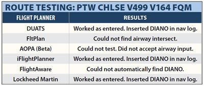
Rather than limit this discussion just to DUATS’ behavior, I tested various flight planners. You can see from the table that most of the planners accepted the airway crossing with no fix specified (V499 and V164) and most were even smart enough to insert the intersection fix, DIANO. AOPA’s planner operating in manual mode failed to recognize the airway crossing, instead giving an “invalid waypoint” error, and FltPlan didn’t recognize that the airways crossed.
I also tested the same planners’ reaction to FRD format. All accepted it except AOPA’s Fly Q Web planner which allows creation of waypoints graphically.
Navigating the Navigator
A strong subtext conveyed by Tim was his desire to edit his flight plan quickly in response to ATC instructions while hurtling through the sky at 100 kt-plus. He noted that editing is done differently in different systems. A Bendix-King KLN-94 is not a G1000, but the editing tasks are the same. You can add, delete, insert before and insert after.
When you get a change that’ll take you a moment to enter, take heat off yourself by asking for an initial vector. Then you are going in the right direction and you’ve bought yourself time to get waypoints into the box.
Our local TRACON prefers that we pick up our clearances airborne if it’s VMC. Frequently, I enter nothing in the box until we receive our clearance. Then I enter the first fix into the flight plan page and head out, loading the remainder as we go. There’s an inherent risk in this approach, though. If you get distracted you might not finish the route entry and then unpredictable things can happen, most of which can get you into trouble.
Tim said he had a VFR GPS in his aircraft. These days, controllers seem to assume everyone has IFR GPS even if they file /U. We were once cleared direct ROGAN, which was impossible without GPS. We had filed /U. So we told the controller we could fly 273 degrees to ROGAN (from our VFR GPS). He approved that, making it legal.
However counterintuitive it may sound, “editing” raw data such as VOR and DME is much faster than twiddling GPS knobs. So Tim, if you want to handle those fast and furious reroutes quickly, stick with your round dials.
Fred Simonds thrives on routing’s finer points as an active CFII in Florida. See his web page at www.fredonflying.com.


