
A long-awaited family reunion is finally happening in Buffalo, New York, just over two-hours’ flight time from your home in Elkhart, Indiana. Two hours, that is, going direct, 331 miles, KEKM-KBUF. You’ve never flown to Buffalo, but you already know direct won’t be possible thanks to some busy airspace up ahead. So you’ve set aside a good hour the day before the trip to figure out the best route to file, unaware that the flight planning will require all of that hour, and more.
Navigating Bravos
Any route flying is still faster than the seven-hour drive, and your Cessna 210 can easily accommodate three passengers and a lot of small bags. First airspace obstacle is Detroit Metro Wayne County. You’re ADS-B Out compliant, so it’s okay to enter (provided you comply with the other requirements in
§91.131, Operations in Class B airspace).
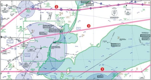
But depending on your altitude and Detroit’s traffic flow, a reroute is likely. Any clues? There are: IFR arrival and departure routes crisscross the airspace with altitudes ranging from 4000 to 17,000 feet. Were you to plow right through and make it unscathed past KDTW, you’d be flying alongside (but not for long) a departure route that runs from 5000 to 17,000 feet.
These don’t appear on the low-altitude en-route charts, so how’d you know? You’ve used VFR Flyway charts to take scenic routes through other Class Bs like Chicago. Clutter-free and not unlike IFR charts in appearance, they depict the airline friendly arrival and departure paths. (These routes also are overlaid on most Terminal Area Charts and digital sectional charts, but can be difficult to spot.)
Naturally, those flying in the system don’t have to worry about all that; ATC handles traffic separation. But for planning purposes, it’s nice to know why you’re going to be moved around, along with where.
Good thing you have those sharp airspace-analyzing skills, because for this trip, you’ve even got a second airspace obstacle: Cleveland’s Class B, with jet routes shown on the TAC. The quickest way to get a hint for a flight plan is to put KEKM and KBUF into your favorite EFB and look at recently issued routes, plus the most windfriendly route offered by the app. The catch with auto-generated routes is that they can get rather lengthy. For example:
BAGEL V277 FWA V144 ZZV V214 LORES V115 MERCY V37 ERI V270 HERMA
This bypasses both KDTW and KCLE. But as you’re not in the mood for a scenic tour of Ohio punctuated with a bathroom stop in Pennsylvania, use this as a rough sketch. Tighten it up by using a couple of select fixes like BAGEL and MERCY, which (nearly) bypass the two Class Bs. Not bad. While doing this, you spotted the Jefferson VOR in far northeast Ohio. Using this
instead “1” adds just 20 miles to the direct distance. But, there’s the matter of the 95 miles over Lake Erie if going direct JFN. You know the C210’s POH-prescribed glide range from 7000 feet is 11 NM, with a gain of 3 miles for every 2000 feet in altitude. So you’ll file for 11,000 feet and give it a conservative 15 miles as an offshore distance limit. Since the route’ll be closer to 20 miles over the lake, plan to request a small heading change to stay closer to shore. Otherwise it’s a nice, easy route that’s worth a go.
Going Through Canada
Next up: The route traverses a bit of Canada in the sector past Detroit. The en-route chart shows the “Toronto FIR” boundary starting just southeast of Detroit. What’s an FIR?
The FAA Aeronautical Chart User’s Guide conveniently includes a legend for a few key Canadian airspace symbols. Those fine blue lines with ticks are Flight Information Regions. But there’s no information about this in the legend, but an on-line search turns up some airspace guides from NAV CANADA.
FIRs are counterparts to U.S. ARTCCs—seven geographic chunks of airspace controlled by Area Control Centres. Using one of the southern route choices, you’ll probably stick with Cleveland Center as the ATC boundaries don’t coincide the national borders here.
By the way, your new ADS-B Out installation isn’t required in Canada at this time, but when it is (by 2023 for aircraft like yours), that nifty 978 MHz UAT system won’t suffice (see “Canada’s ADS-B,” IFR, October 2019). So just worry about tomorrow.
What if your ADS-B goes inop en route? A reroute to bypass Detroit and Cleveland airspaces is likely (brace for that Ohio tour). Still, it doesn’t hurt to ask. As the FAA explains in its “without ADS-B” policy notice, the limitations apply more to operations at “capacityconstrained” airports like an O’Hare or LAX: “ATC authorization requests into or out of other airports located in the Class B airspace or Mode C Veil associated with the capacity-constrained airport, or to transit that airspace, will be evaluated individually.”
What about Buffalo’s Class C? Depending on your status (inop or unequipped), each has a procedure to potentially allow you to enter a given airspace, as provided in §91.225 (g)(1) and (2).
Inop ADS-B? Report to, and request from, ATC, continuing “to the airport of ultimate destination, including any intermediate stops, or to proceed to a place where suitable repairs can be made or both…”
Unequipped? The rule requires submitting a request at least an hour ahead of arrival. The FAA requires an on-line request within 24 hours via its ADSB Deviation Authorization Preflight Tool (https://www.faa.gov/nextgen/ equipadsb/adapt/). An automated response pops up, with the final answer emailed to you. (I’ve been in both inop and unequipped aircraft recently and these procedures work well, at least going to Class C airports.)
There’s Class F?
Just when you think it’s coming together— after over an hour—the convective forecast for northern Ohio has degraded into a real chance of thunderstorms. You prefer diverting south of the route rather than north over water or into Canada proper, but as the weather’s much better to the north you can’t resist the urge to scope out northern routes around Detroit.
More route searches bring up fixes including the Salem VOR (SVM) northwest of Detroit and 2 FNT-T781- DERLO-T608. That blue-airway T route is also new to you, so you go back
to the Chart User’s Guide to confirm it’s a low-altitude RNAV airway with an obstacle-clearance route MEA, and
the “G” suffix indicating a GNSS MEA.
Designed for routing around busy airspace, T-routes usually give Class Bravos a wide berth and often have MAAs (Maximum Authorized Altitudes) to keep traffic below jet routes. Use this as the Plan B, so to speak.
Need anything else when passing through Canadian airspace from one U.S. airport to another? Technically, your FCC radio station license and radio operator’s permit are required in non-U.S. airspace, but these won’t get checked unless you land in Canada. That also means you don’t need passports or customs paperwork, although those who do this regularly take passports in case of a diversion into Canada. Wouldn’t hurt to have everyone take those along.
The SVM-to-KBUF 3 route also cuts through a piece of Canadian Special Use Airspace, CYA 513, near the destination. The Chart User’s Guide calls this an Advisory Area. By now, you’ve obtained your own digital copy of the Canada Designated Airspace Handbook that says: “Airspace may be classified as Class F advisory airspace if it is airspace within which activity occurs that, for flight safety purposes, non-participating pilots should be aware of, such as training areas, parachute areas, hang gliding areas, military operations areas, etc. There are no specific restrictions which apply to the use of advisory airspace. … Pilots of participating aircraft, as well as pilots flying through the area, are equally responsible for collision avoidance.”
And: “ATC will not clear IFR aircraft through Class F airspace except if: (a) The pilot states that he/she has obtained permission from the user agency to enter the airspace; (b) The aircraft is operating on an Altitude Reservation Approval; or (c) The aircraft has been cleared for a contact or visual approach.” So CYAs are similar to U.S. Military Operations Areas, and ATC might steer you around them if IFR. No big deal.
Now going on two hours of preflight planning and armed with extra airspace knowledge, you’re finally ready for tomorrow’s trip. Don’t forget to save the chart legend, Canadian airspace guides, and all those route options. You might need a different one for the flight back to Elkhart.


