
Often, the word “front” raises anxiety and apprehension in aviation meteorology. It carries the possibility of showers and thunderstorms, signals a change in the weather regime, and means the distinct possibility of a busted forecast. Thankfully there’s nothing to fear. Fronts are now well understood— computer models have become excellent at handling the underlying air masses that drive these weather systems. But to avoid the little details that often get us in trouble, we need to have a better understanding of what we’re looking at. Let’s break it down.
Let’s first look at FAA publication AC 00-6B, Aviation Meteorology, the bedrock on which flight training in the United States is largely built. Here we find an entire chapter dedicated to fronts, and the chapter heading shows that fronts are closely bound with air masses and the wave cyclone model. This makes sense, as fronts simply mark a division between air masses, while the wave cyclone model describes the change in structure of both air masses and fronts over time as heat and moisture interact with each other.
Building Blocks of Fronts
Air masses are the building blocks on which we understand weather systems. The chapter gives us a very important definition: air masses consist of a large body of air with generally uniform temperature and humidity. Though the FAA publication simply prints this one sentence, this is actually an important concept that meteorologists use in forecasting; indeed, journals and research papers are often founded on air mass behavior. Much of our daily work is based on identifying air masses with homogenous characteristics. Using this principle, we can assume that most of the air parcels (imaginary volumes) in the air mass have a common history, having come from the same general source area and having been affected by the same weather processes, and will generate the same sorts of weather.
When a single air mass is present, the weather is likely to be the same, governed almost entirely by diurnal, cyclic changes like solar heating, radiational cooling, and sea/land and mountain/ valley breezes. Such a weather pattern is common in the tropics, in subtropical deserts, and during the winter in polar regions.
But when two air masses are present, they’re often divided by an air mass boundary. This is actually a meteorological term that is in widespread use. Air mass boundaries include cold fronts, warm fronts, stationary fronts, and occluded fronts. It also includes lesser-known boundaries not often covered in pilot training, such as drylines, outflow boundaries, and upperlevel fronts.
Boundaries with temperature contrasts are exceptionally important. When the contrasts exist through depths of thousands of feet, they dramatically affect the structure of the middle and upper troposphere by lowering the “constant pressure levels” over cold air and raising them over warm air. This in turn increases the pressure gradient, which increases pressure gradient force, leading to acceleration of the wind and the creation of jet streams. In an almost Rube Goldberg series of events, interaction of air with the jet stream
then creates powerful vertical motions that shape
the weather systems in the lower levels.
We’re most concerned with areas of wind convergence, as this compresses and strengthens temperature contrasts. When you look at a weather map and see the winds coming together in one particular area, those temperature contrasts are amplified.
A good way to get this convergence is through upward vertical motion. The principle of mass continuity states that upward motion must be accompanied by lower-tropospheric convergence and upper-tropospheric divergence. A hurricane is a great example of this. When you see the satellite animation of the storm on TV, look for the inflow bands spiraling into the storm, capped by thin, wispy spiral cirrus outflow moving away from the storm at heights of 40,000 feet or more.
And quite often it is indeed upward vertical motion, usually from an upper-level disturbance, that develops the wind convergence and intensifies temperature contrasts. This results in the development of frontal boundaries, a process known as frontogenesis.
The Cold Front
In a cold front cold air is replacing warm air. The cold front brings some rapidly changing weather, including showers or thunderstorms.
As with all fronts, the cold front starts out shallow—only a few hundred feet deep near its leading edge— then becomes deeper with increasing distance into the cold air mass. The deepening per-unit distance can be expressed as a slope. A typical slope for a cold front is about 1:100 on average. This means 100 miles behind the cold front, you can expect the cold air depth to be about 1 mile, or 5000 feet.
Cold fronts can also be described in terms of their maximum depth of the cold air mass within the cold air advection zone trailing the front. Typical depths in the United States range from 5000 to 15,000 feet.
Shallow fronts on the Great Plains might have a maximum depth of only 1000 to 2000 feet with a warm tropical air mass above. These are sometimes associated with showers and thunderstorms in the tropical air mass above. There have been cases where tornadoes dropped out of storms in these air masses, such as the southwest Oklahoma supercell in February 1975, which produced an F2 tornado with surface temperatures near 40-degrees F.
By contrast, there are also very deep cold-air masses that can clearly be identified at heights of 15,000 to 20,000 feet. Unlike shallow air masses, these are capable of flowing over mountain ranges and through high mountain passes. Quite often when unusual cold air outbreaks reach Utah, the Four Corners area, and into Arizona, it’s because of one of these deep air masses crossing southward or southwestward from the western half of Canada.
Stable or Unstable
Stability is a critically important measure for pilots because it shapes the weather you’ll encounter. You’ll recall from our previous discussions about stability that cold-over-warm means unstable air, while warm-over-cold means a stable layer and possibly an inversion.
Now let’s take a typical situation, say in Kansas City. Let’s assume the front passed us about four hours ago. Given a typical movement of 25 mph, this yields a distance of 100 miles to our south. Using the 1:100 slope, we can assume the cold air is now about 5000 feet deep. Now let’s take a look at the structure of the cold air.
The most potent cold air will be advecting in just above the surface, at altitudes of a few hundred to a few thousand feet. Here, the northerly winds are the strongest. Meanwhile, the surface layer is continuously being heated by the ground. Even if the sun isn’t out, heat will still be conducted into the base of
the air mass from the soil and bedrock, which forms a vast heat sink.
This gives us a shallow layer of very cold air above cold air, in other words, it’s unstable. First of all, this yields gusty winds at the surface. Second, it disperses any haze or fog. But if there’s
enough ground moisture or if the air mass is humid enough, the instability will rapidly develop shallow but vigorous convective cloud layers.
Ascending to about five thousand feet, we reach the top of the cold air mass. This brings us to the frontal inversion. Here the temperature drop with height ceases or even reverses, forming a thermal inversion. Any low-level clouds tend to stratify beneath this layer.
Above this level we enter the “warm air mass.” Though it might not be warm in terms of temperature, we would find it consists of the same sort of air we find in the tropics. Abundant moisture may also be present here. Conditions might be hazy, much like what you’d find in the southern or eastern United States during the warm season.
Overrunning
Sometimes a so-called “overrunning” situation is present within the tropical air. This is most likely to occur when the wind at this level flows toward the cold air. In other words, if there is a southwest-to-northeast front, a southerly, southeasterly, or easterly wind produces overrunning. Although the reason for this is beyond the scope of this article, suffice it to say that air prefers to conserve its potential temperature, and potential temperature surfaces are always sloped upward over cold air, loosely following the upward slope of the frontal surface. Air clings to these surfaces like a cat trapped between bedsheets, moving upward as it reaches a pillow lodged beneath the sheets, which represents the cold air underneath.
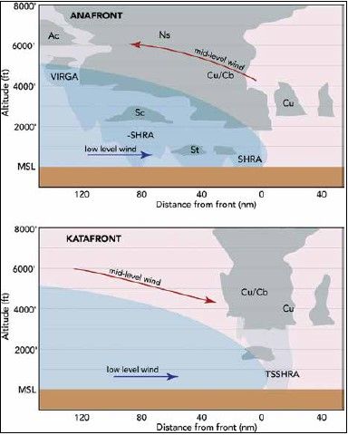
This type of overrunning front is called an anafront. The American Meteorological Society Glossary of Meteorology defines anafront: “a front at which the warm air is ascending the frontal surface up to high altitudes.” With anafronts, the majority of the precipitation is found behind the cold front. Embedded thunderstorms and showers may occur here. Anafronts are exceptionally common in the western United States, as well as in the central United States during winter. The pattern is favored when there is upper-level troughing west of the front.
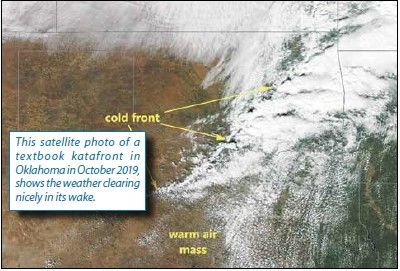
But other times, we have a katafront. The wind flow is toward the warm air. In other words, with a southwest-tonortheast front, the wind along the frontal surface is blowing from the west, the northwest, or north. This results in descent, which almost always means improving weather and clearing. Again, we are speaking strictly of the warm air mass overlying the front, not the air within it. This type of system is often observed in the central and eastern United States. Upper-level ridging to the west of the front favors a katafront.
Weather can still occur with a katafront but it’s typically found along or ahead of the front. Katafronts are often dry, with little more than a wind shift, a temperature drop, and rapid dissipation of MVFR and IFR conditions. But squall lines and severe weather outbreaks are likely along and ahead of the front if rich surface moisture is present and the warm air mass is unstable.
Other Fronts
You’ll notice that we haven’t discussed warm fronts. I feel it’s important not to think of them as a structurally different type of system. In many respects, the warm front is the same as a cold front—only air masses are moving a little differently.
The warm front, by definition, is a front in which warm air is replacing cold air at the surface. This means that most of the drive comes from the advance of warm air. So it behaves very much like an anafront and technically is one. But the cold air mass as a whole is losing ground, receding back toward the cold air. This is caused by pressure falls in the cold air, which puts the brakes on the southward advance of the cold air, or pressure falls to the west, as we might see with an approaching low pressure system. Not surprisingly, warm fronts are often found east of a low.
Sometimes the cold front slows down or stops. At this point, it becomes known as a quasistationary front. No front is actually perfectly stationary; there’s always some movement. So the term is used to refer to movement of five knots or less.
Finally that leaves us with the occluded front. There’s not time to cover this, as we would need yet another article to explain the development of a surface cyclone and how the fronts and air masses interact. But in short, it’s what we get when the cold front catches up to the warm front near a deep surface low. The warm air mass is displaced aloft, its deepest point called a “trough of warm air aloft” (known as a TROWAL to Canadian pilots), and the meeting point of the other two air masses at the surface comprise the occluded front.
Perhaps one valuable takeaway is that anafronts and warm fronts generally present the greatest icing hazard risks. To get the formation of large supercooled droplets, we need ascent of warm, moist air, and there’s no better situation than in those types of fronts. These are the conditions that brought down an American Eagle ATR over Roselawn in 1994.
The hazards presented by katafronts will be mostly in the realm of turbulence and convective weather. Since katafronts move swiftly with strong solar heating, air mass modification is more lively and this means more vigorous mixing, with low-level mechanical turbulence and wind shear especially during the daytime.
Now that you have a better idea how these fronts are built, you can look for them on surface and upper-level charts when planning your flight. And with the insight we’ve presented here, you’ll have a better idea what might be in store as they develop, and what alternatives you might consider.


