
When you were seven, your mother sent your father to the store for milk, and he came back three years later—but only because he got lost. At least that’s the way your mom liked to tell it. Now it’s time for your dad to see his granddaughter (your daughter) graduate from the University of North Carolina at Asheville. Unfortunately, that’s a liberal arts school, so you’re really celebrating your child moving back in with you in about a month. But hey, at least everyone was happy for the last five years. (Yeah, five. Don’t ask.)
No-GPS Setup
Your dad’s drive from Greenville would be simple, except there’s a widespread GPS outage due to some military testing that seems to have gone awry. Your dad can’t find his way to tomorrow without Siri, and neither can all the other motorists clogging the streets. If the two of you will make this graduation, you’ll have to do it by air—and with only two basic nav radios. Ready?
Your bad day begins on the ramp in Andrews, NC (KRHP). Go into your sim/ iPad set upand fail GPS as well as disable sending position data to the iPad. Also fail any DME or ADF equipment you might have, or pick a bird without it. Some sims can’t fail just the GPS of a GPS navigator. If so, turn in to a screen with no map or motion data.
If you fly an eHSI in the real world, try to do that on the sim. Dual nav on these setups usually require bearing pointers (RMI needles). It’s amazing how many glass-panel pilots have no idea how to enable and control these. Do you?
Set the winds out of the south at 10 knots near the surface and out of the southwest at 30 knots up higher. Set 3200 AGL ceilings (really, trust us) and a vis of two miles. That’s 4900 MSL if your sim requires it. Turbulence for this flight is your choice. Fire up and taxi out for Runway 26. Enjoy how just taxiing around on the sim can be a challenge without a moving map. Oh, and have a timer ready.
Fly It
You filed for Greensville-Spartanburg (KGSP) with a route of HRS V54 SPA at 7500 feet. Your clearance comes back simply “as filed” with a release window of a luxurious 15 minutes. Must be no one else is crazy enough to be flying today. Get situated and fly the ODP as published. Once airborne drop the ceilings at your destination to 1000 AGL and vis to a couple miles.
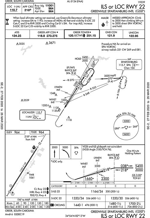
Cruising down V54 somewhere before SUNET, you get a text from your Dad. He’s actually at Greenville Downtown (KGMU), and he’s not moving. Their only non-RNAV approaches are two ILS approaches to Runway 1, but those use an NDB for the missed approach. To fly them you need alternate missed instructions. ATC isn’t buying it, so you ask for the ILS Runway 22 into KGSP figuring you’ll Uber over to get Dad. The controller tells you to cross UNMAN at 7000. After UNMAN cleared direct RAYCE. Cross RAYCE at 5000 and hold as published.
Enter the hold at RAYCE and stay there until you can nail a minute inbound, because that’s when the controller will decide you’re worthy and clear you for the ILS Runway 22 approach. Be sure to have the tower and ground frequencies tuned.
Fly to the DA and land, before realizing with these ceilings you can go to Greenville Downtown visually if you get a Special VFR out of this airspace and into KGMU. Taxi back to Runway 22, tune all the frequencies you need to make this work and depart visually for KGMU.
Depart. Find the other airport. Land and retrieve Dad.
The weather got worse while you waited for Dad to finish telling the line staff about his colonoscopy, so set ceilings to 2700 MSL (500 AGL at KAVL), but dial the wind back to just five knots from the south. File direct out of habit and then face palm yourself when you get a full route clearance: “… On departure fly heading 186, radar vectors, SPA, Direct. Climb and maintain 7000 …”
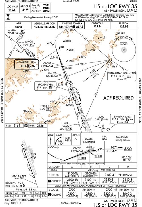
Fire up and launch again from Runway 19. Climb until reaching the altitude in the departure procedure, and then assign yourself, “Fly heading 090 to join V266. Resume own navigation.” Cross SPA at 7000 and assume cleared for the Localizer Rwy 35. Did we mention that the glideslope is out of service? If you can, fail only the glideslope in your sim. No cheating on the step downs.
Too bad that glideslope is out, because you’re going to miss. Fly that as published and use the holding pattern to make your own course reversal to head for SUG at 7000 on R-312. While you lick your wounds and wonder when this day will end, bring the ceilings at KAVL up to 800 AGL, but increase the winds from the south by a knot or five.
If you’re a glutton for punishment, go all the way back to SPA. If not, cross SUG at or above 6000 and fly the published transition from there for a second attempt. Fly the approach and either land downwind on the 7000- foot runway or circle for Runway 17. Your call. Land and enjoy the graduation.
Afterwards, Dad asks when you’re f lying him back. You say he can wait until GPS is back on or the sun comes out. The two of you are going to meet his granddaughter for a beer.
How’d You Do?
Be sure to fly this (at least in your armchair) before going through these questions to see what you might overlook.
1. Could you depart KRHP if the ceiling was less than 3000 feet? How would you do it? If you had to make an emergency return to KRHP once IMC, how would you? When did you transition to a cruise climb? How did you keep the airport in sight in the sim?
2. Suppose you had GPS and made it to 7000 feet before reaching HRS (or even R-356), could you proceed on course from there or do you have to reach HRS first? Why is the DP radial inbound to HRS 356 when the airway is 001? The other end of the airway is 356.
3. When will you change VORs on V54? Suppose you wanted to stay at 7500 even though the MEA is 8000. Could you request it? How much needle deflection did you allow on this leg?
4. How do you identify UNMAN? RACEY? Did you start a timer?
5. Is that Special VFR plan even legal? How did you find KGMU? What happens if you overshoot it by five miles or so?
6. The DPs out of KGMU all talk about turning north or west. How high must you go before turning east per the DP?
7. How do you know you’re approaching SPA for the transition on the first KAVL approach? Do you lead the turn? Did you have fun with the stepdowns?
8. Is this KAVL ILS or LOC Rwy 35 legal without an ADF? Did you start a timer? Did you have everything dialed up for the first missed?
9. On your second try at KAVL, which way did you circle to land on Runway 17? …or if you wanted to circle back for Runway 35?
Bonus: On the KAVL airport diagram, what’s the dotted area that looks like a runway or taxiway, but isn’t filled in?
1. You could depart, but you’d have to roll-your-own procedure, and given the stipulations on this seriously non-standard VCOA, it’s probably a bad idea. You’d also be on your own to come back. Knoxville 31 miles north might be best.
2. You could call everything before HRS part of the departure, so you could go direct HRS when you want. You could even go straight there on takeoff if your research said you’d outclimb the terrain. As for the radial mismatch, the two VORs were probably aligned on different dates. The slightly different path to HRS probably allows for 7000 feet rather than the airway 7800.
3. You change at SUNET, which you ID by R-353 from ELW. You could ask for 7500 but you might not receive the VORs. Needle deflection: It’s amazing how off course you can be on a 100-mile airway. Can you still fly a VOR course?
4. UNMAN is R-177 off SUG. RACEY is where the I-LMU crosses the SPA R-270, one degree off of V54, or 1000 feet at 10 miles—close enough to say RACEY is on V54. The fun part is some quick change of primary nav and secondary nav. We wouldn’t bother timing the ILS. If the glideslope quit, we’d go missed and regroup—and ensure that’s all that was malfunctioning given there’s no GPS for backup position.
5. It would be legal because the airport surface areas abut. KGMU is roughly where SPA R-248 and SUG R-192 cross. Miss it and fly too far though and you’re in Class E airspace VFR with insufficient visibility. Got that ASRS form?
6. We read this as you can turn east passing 400 feet AGL, baring some restriction from ATC. But that’s almost certainly what you would get: A heading to fly from Tower and then vectors because of the traffic to the east of you.
7. You could use V53, SUG R-145. Technically, you don’t lead VOR turns, but it would sure help you get onto R-287 if you did, so we’d do it by a few degrees before SUG R-145. If you stressed the stepdowns, remember there was a tailwind. Listen to it whistle while we play our tiny violin for you.
8. “ADF Required” in the planview states a requirement for transition from the en-route environment. We think this is only for the MSA, so we’d say with ATC radar and communication, you’re at least near the right side of the regs. We won’t tell if you don’t. You started a timer to identify the MAP and accounted for the tailwind, right? As for the missed … that one caught us sleeping the first time, and with the tailwind it comes up quickly. You need HMV R-213 for the hold.
9. Circle how Tower instructs, but the pattern is normally left for 17 and right for 35. Oh, did you identify all the navaids?
B: If your sim models things accurately, you saw it. It’s a closed runway.


