
What comes to mind when winter hits? In the east we think of Nor’easters, snowstorms in the Great Plains, and IMC in the southeast. We think of the western states as dominated by clear skies and light winds. Our perceptions are probably influenced a bit by the constant news of drought and wildfires, the sunny ambience of Hollywood movies, and maybe that 1970s song about it never raining in southern California.
If you’ll be flying west of the Rockies, though, don’t let your guard down. Reality is that the West is not always blessed with clear skies and mild weather. The worst of the flying hazards occur during the winter, and some of them can be just as severe as the problems out east. Thankfully we’ll sort things out and help you figure out what to expect.
Top-Down View
During the winter across the United States, the prevailing westerlies have strengthened and the average jet stream dips southward into the northern and central United States. This means that storm tracks and air masses are on the move across much of the country.
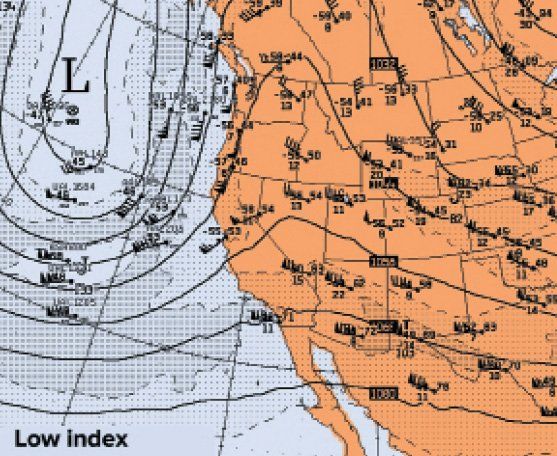
The weather regime that exists in the western states is largely controlled by the zonal index, a measure that indicates whether the mean tropospheric flow is mostly going west to east (high index), or whether there is a significant north to south component or vice versa (low index). You can easily get a sense of this by looking at winds aloft charts around 15,000 to 25,000 feet as shown below.
When a high index pattern is in place, the weather tends to be fair and systems move progressively. Mid-level winds are strongly west-to-east. This pattern is often described as “zonal.” As this pattern tends to cross perpendicular to mountains, moderate to severe clear air turbulence is possible when winds are above 100 knots. Most of this turbulence occurs along and downstream from mountain ranges, and mountain waves can develop.
The occasional low index pattern is most often seen from December through February. Mid-level winds show strong northward or southward components. Deep troughs develop along the west coast, bringing poor weather to California before moving inland. During these weather regimes, the weather is unsettled and computer models have more problems forecasting successfully. Snowstorms are very likely in Nevada, Utah, and northern Arizona.
Pacific Fronts
In summer, the Pacific storm track focuses mostly on British Columbia. But in winter, the track shifts down the coast to Washington and Oregon, and later in the season, into northern California. As you might suspect, this shift is correlated to the southward march of the polar jet.
When disturbances cross the Pacific Ocean and the jet stream is pointed inland, the pattern is ripe for the coastal states to be hit every few days by well-developed frontal systems with extensive icing and turbulence. Airports might be brought down to MVFR or IFR conditions, mostly during the hours before the cold front arrives. Gusty winds are also common, with southwesterly directions as the system approaches, then shifting to northwesterly.
These systems produce the majority of the winter storms in the Sierra Nevadas and Cascades. Most of the moisture is blocked by the mountains, so for places further east like Reno, Las Vegas, Boise, and Spokane the conditions are mostly confined to overcast middle and high clouds with brief snow showers.
During low index patterns, these frontal systems can be quite deep, even extending into southern California, producing cold-core lows and showery weather. This also tends to allow moisture to circumvent the Sierra Nevadas through the Mojave Desert into the Great Basin, causing snowstorms eastward into Utah. These deep storm systems are particularly favored during El Nio years (the pattern this winter is neither El Nio nor La Nia), but they can occur in any season and they’ll definitely have impacts on your flying plans.
The Subtropical Jet
In winter, we also see the subtropical jet. This is similar to the traditional polar front jet stream, except it occurs at higher altitudes and closer to the tropics. The subtropical jet is usually a high-level phenomenon. The only pilots who are aware of its presence are jet jocks up at 39,000 feet riding a 150-knot tailwind, while Mooneys at 15,000 see nothing more than a 20-knot headwind.
Weather around the subtropical jet usually is little more than broken to overcast cirrus, often with distinct transverse banding. However, at high altitudes, these subtropical jets can be a significant source of clear air turbulence due to the strong vertical wind shear. Also the subtropical jet loves to link with polar jets and frontal systems approaching from the west, producing a potent coupled jet that extends to much lower altitudes.
The subtropical jet is absent in summer. During the winter it is usually found in Mexico or from the Gulf of Mexico across Florida to the Atlantic, driven by upper-level temperature contrasts. Winds are often over 80 knots and can be as high as 200 knots, particularly in February. When very deep systems approach from the west, the subtropical jet tends to be drawn northward to 30-35 degrees.
If there is a deep weather system developing to the west, with a low zonal index, the subtropical jet often marks a vast conveyor belt of moisture from tropical latitudes into the western states. Television forecasters often call this the “Pineapple Express.” In meteorology it’s a warm conveyor belt.
These are rivers of rich water vapor flowing northward with huge moisture flux values. They are responsible for the vast majority of the moisture that reaches northerly latitudes in the winter. These belts are filled with broken to overcast middle and high clouds, thickening into precipitation and low ceilings close to the front. In these zones near the front, there is often flooding rain at lower elevations and heavy snowfalls where the patterns cross the mountains.
Cold Waves
When bitterly cold Arctic air develops in western Canada, we normally see a cold front sweep southeast across the Great Plains. Areas west of the Rockies aren’t affected, and a mild, stagnant weather pattern prevails there because the depth of these cold air masses averages only about three to five thousand feet. With Denver above 5000 feet and the passes averaging 9000 feet MSL, flanked by tall mountain ranges, there’s little opportunity for the cold air to spill westward.
But a few times each year a Canadian air mass is extremely cold and deep, building to 10,000 feet or more. The Rockies won’t hold back air this deep, and like a tsunami rolling into a town, the enormous bulk of dense air flows past the mountain ranges. These air masses tend to anchor further west in British Columbia, allowing them to perform a flanking maneuver and advance southward into Washington and Oregon through the north-south valleys, driving a cold front far south.
This cold air advection brings the danger of canyon winds when the cold dense air is channeled through passes and down canyons on the other side. Not only is it driven by the strong pressure gradient, but due to the air’s density it also accelerates. In many parts of the western United States, these canyon winds tend to be easterly or northeasterly, though northerly winds can occur along the Oregon-California border.
Areas notorious for canyon winds are the passes east of Seattle, the Wasatch Mountain passes east of Salt Lake City, and even the canyons east of Albuquerque. High winds can extend down river valleys all the way to bays and inlets, such as the Inside Passage of the Pacific Northwest. Winds of 40 to 50 knots are common. The descending air mass can also develop waves, with hydraulic jumps causing winds to reach 80 to 100 knots in localized areas. Airports along the foothills leading to major passes are at greatest risk of damaging winds. Even if you do find a good airport, you can expect moderate to severe mechanical turbulence from the surface up to 10,000 feet or higher.
Great Basin Highs
Clear skies and dry air in the plateau region between the Rockies and the Sierra Nevadas means that nighttime radiational cooling here is extremely efficient, especially during the cold season. In early October, while nighttime temperatures in Denver begin sinking into the 50s, places like Winnemucca and Elko in northern Nevada are already falling below freezing. During the worst cold waves these stations can reach as low as -40 degrees F. Day-to-day mean temperatures are low enough that the dense air affects barometric pressure, resulting in a semi-permanent high pressure area centered in the northeast half of Nevada or adjacent areas of Idaho and Utah. This is referred to as a Great Basin high.
When the Great Basin high strengthens, it shapes the wind field through the western United States, raising barometric pressure and producing north to northeast winds at Las Vegas, Reno, and Salt Lake City. As this Great Basin high is associated with a warm-over-cold profile in the atmosphere it tends to be stable. Pilots can expect lots of fair weather, light winds, and favorable density altitudes. However this same temperature profile encourages the development of inversions. Recent snow cover is an important indicator because it provides residual ground moisture and insulates the surface layer from the soil, deepening the cold air mass and allowing fog and stratus formation.
If the fog and stratus develop, they will typically persist. Many of the valleys in the Great Basin form irregular bowl shapes, decoupling the surface air mass from the air mass above the inversion, while radiation from the top of the clouds helps cool the air mass below the inversion. The pattern can persist for days or even weeks until a large-scale disturbance increases winds and flushes out the stagnant air masses.
This weather pattern is most often seen in the Salt Lake City and Snake River Valley regions in December and January, as well as in many of the valleys on the west side of the Rockies. Generally you can expect lots of great flying weather above five to seven thousand feet MSL, but below that you’ll be putting your instrument skills to the test.
The Santa Anas
When the Great Basin intensifies to unusual levels and the region becomes abnormally cold, a strong pressure gradient forms between Nevada and California. Las Vegas winds become cold and gusty out of the north. The air in the Great Basin is already quite dry, and the conveyor belt of air from central Nevada to southern California moves gradually downslope, decreasing the relative humidity. Due to conservation of momentum this broad region of high pressure area is replenished with upper air that is also quite dry. This means that southern California becomes a tinderbox.
The cold air gradually warms as it travels southward, and is forced through mountain passes into the Los Angeles and San Diego area. Combined with the tight pressure gradient and the unstable atmosphere (cold-over-warm), the wind speeds become high and quite gusty, especially during the daytime hours. Combined with the dry conditions, this means that wildfires easily get started.
The worst of the smoke problems are usually localized to a small area, but the plume can diffuse over a wide area, restricting visibility around coastal airports. Wind directions normally range from 060 to 090 degrees, so the plumes usually blow offshore. Your main effects might be the unexpected departure from the normal northwesterly flow; airports will be using east flow patterns. You’ll also find that many airports will exceed your crosswind limits during the day. The winds fortunately do improve by evening. Since this is offshore flow, fog and stratus is blown far out to sea and conditions outside the smoke are VMC.
Santa Ana winds are typically created when there’s an incursion of bitterly cold arctic air across the Rockies that supercharges the Great Basin high. This allows northeasterly winds into California. This air tends to be cool at night and mild during the day, but if the cold air mass is strong enough, hard nighttime freezes can affect Phoenix and southern California. The effects are devastating to vineyards and citrus farms.
Winter Fog
Finally some mention should be made of winter fog. This is radiational fog that often fills the Willamette and Columbia valleys of Oregon and Washington, and the San Joaquin Valley of California on winter mornings. In California it is known as “tule fog.”
All that’s needed is a stagnant weather pattern and good soaking rainfall. Clear skies and strong radiational cooling do all the rest. Unlike in the eastern states, this fog doesn’t always dissipate in the afternoon because of the blocking effects of the mountains. The fog may “lift” into an overcast stratus layer and then thicken again at night, keeping airports in IMC for days. This is particularly common in California, where patterns may be too stagnant to mix out the fog effectively.
Fortunately the forecasters in those areas know exactly how to anticipate this hazard. You don’t need to try to predict it. All you need to do is keep close tabs on the TAFs, and by recognizing the fog’s origins and its behavior you’ll have some idea when the forecasts will clear things out.
If you live and fly in the West, you’re probably familiar with all this and hopefully you’re now better equipped to understand it. But, if you’re just planning an infrequent flight west of the Rockies, now you know what you might encounter.
Tim Vasquez spent three years out west as a meteorologist for the F-117A program in Nevada. He’s now in Texas writing weather textbooks.


