
Police-officer friends often share frustration they have piecing together an accident from testimony of the participants and the witnesses. Everyone has their own biases and perspective.
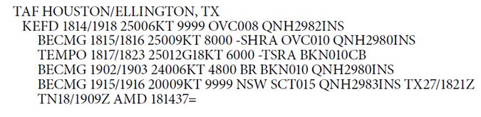
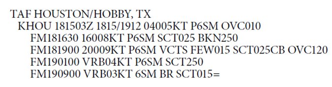
Recently, a friend who flies out of Houston Hobby (KHOU) shared something that’s bothered him for some time. Just seven miles east of Hobby is Ellington Field (KEFD), a joint-use military/civilian airport. Both airports issue TAFs. Hobby’s TAFs come from the NWS and Ellington’s are issued by the military. Interestingly, sometimes there is a great disparity between the forecasts. Do they each have their own biases? Are they looking through different glasses? It’s like asking two witnesses what they see in an accident that hasn’t happened yet.
NWS TAF
We’re all familiar with the NWS terminal aerodrome forecast (TAF)—forecasts for weather within a 5 mile radius of the given airport. Sometimes these spot forecasts will also mention weather for a donut-shaped area out to 10 miles. These forecasts cover a 24-hour period (30 hours at major airports so some airline dispatchers can plan long-distance flights).
NWS TAFs follow the same general format as familiar METARS. The forecast begins with the date and time it was issued (4 times a day) and covers the entire period of the forecast. Each time period is followed by METAR-like data—wind (aligned with true north, which is often misunderstood), visibility in statute miles, significant weather (especially if it affects the visibility), and cloud coverage.
The specific forecast periods found in the NWS TAFs are presented in several ways. Most of the time the specific periods begin with FM (From). This means the change in weather is assumed to begin within one hour during the time period. Occasionally you will see a TEMPO line. TEMPO means that there is a temporary change assumed to occur that will last for less than an hour and for less than half the period of the TEMPO group. Also you might see PROB followed by a two digit number which represents percentage. Usually these are PROB30 (30% probability of occurrence). The PROB category is a percentage of a chance of weather change during that period. The NWS tries to stay away from PROB and is actually constrained by not being able to use it during the first 9 hours of the TAF.
Military TAF
Military TAFs begin in much the same way. Note that they need not be ICAO compliant. Military TAFs do not show an issue date. It simply begins with the forecast period. Military TAFs are usually valid for a 30 hour period. Then the familiar elements of wind, visibility, significant weather and cloud coverage follow. There are some significant differences in these elements as well as additional ones.
One difference you might notice immediately is the use of BECMG (Becoming) rather than FM. BECMG denotes a gradual change in conditions from the previous period to the end of the current period. It is not quite as dramatic or sudden a change as the FM used by the NWS or even TEMPOs. BECMG was used in NWS TAFs until about 10 years ago but was dropped. (it’s still in the AIM, though). Perhaps it was dropped due to users misunderstanding its meaning.
Military prevailing visibility is stated in meters rather than statue miles and values greater than 7 statute miles are stated as 9999. Also, the TAF includes forecast air pressure with the additional element of QNH (altimeter setting). Occasionally it will also include forecast wind shear by including the element WS with the height of the shear as well as the direction and speed (e.g. WS010/18040KT—wind shear at 1000 feet 180 true at 40 knots). This is non-convective wind shear that isn’t associated with a thunderstorm.
Additional elements are often included in the military TAF. Forecast icing is denoted by a “6” code (e.g. 620304). Your decoder ring would read this as icing (6), intensity (2), base of the icing in hundreds of feet AGL (030), and depth of the icing layer in thousands of feet (4).
Turbulence, if forecast, follows the icing group and uses a code of 5 (e.g. 520004). The (5) specifies turbulence, (2) denotes intensity, and much like the icing group the next three digits specify the base (in this case the surface), and the depth in thousands of feet.
The final element in the Military TAFs, found on the last line of the forecast, is the forecast temperatures. These can include both a forecast minimum and maximum temperatures with the times they are expected (e.g. TM08/18Z 02/11Z: Temperature (T), minimum -8 degrees C (M08), at 1800 Z, maximum 02 degrees C at 1100 Z).
So how does this play out in the real world? Do different witnesses see the same thing in a different way? One only has to look at TAFs for the same period to understand there is a major difference. The Ellington TAF—for an area that overlaps Hobby’s—seems more specific and pessimistic than Hobby’s. Wind, ceilings, and significant weather are much worse. Could it really be about the witnesses and their biases?
Digging Deeper
In 2003, Scott Dennstaedt wrote an informative article for IFR about the creation of the NWS TAFs. He pointed out that while Area Forecasts are developed by the Aviation Weather Center in Kansas City, the TAF is a created by the local Weather Forecast Office. The WFO forecaster on duty is briefed by the previous forecaster and then begins to see how the synoptic picture begins to unfold. A big part of the next TAF comes from Model Output Statistics (MOS) of the computer Model Forecasts as well as persistence of the current conditions. They then apply their local or “sub-synoptic” experience to create a forecast that reflects both the big picture and local events. It’s a combination of computer outputs and the experience and bias of the forecaster. When all this comes together, a TAF is generated and published at six-hour intervals with occasional amendments as required.
The NWS forecaster is ultimately working for their customers, who include the general public plus businesses and airlines. One might think this could influence the forecaster.
Airlines are dispatched by a specific set of rules, and in marginal conditions the forecaster often knows what’s required. Sometimes this knowledge can unconsciously (or perhaps consciously) contribute to a somewhat optimistic outlook. (For example, if the forecaster is honestly uncertain of the exact wind direction but one possibility would constitute a no-go, the forecaster might choose to err on the side of “go.”) Similar bias can also affect the military forecaster.
Military forecasts begin with the 557 Weather Wing of the US Air Force. They forecast the weather for Air Force, Army, and Allies and are based in Nebraska. Below the Wing are specific Operational Weather Squadrons with a local focus. (The 26th OWS, based out of Barksdale Air Force base in Louisiana, serves Ellington.) Each OWS is tasked with forecasts for specific regions. The forecaster uses many of the same models that the civilian forecaster uses. (See the sidebar.) However, it seems the goal of the military forecaster is much different.
Rather than give their customers (fellow military) the benefit of doubt, the goal of the military forecaster is to be not only brutally honest, but even pessimistic. They are preparing the crews for the worse conditions that they might face. They are the jaded eye at the scene of the future occurrence.
Whenever we prepare for the next flight we are basing our planning on the testimony of witnesses “before the fact.” Much like my police friends, we have to keep this in mind when trying to investigate what will happen. The “glasses” through which they see things differ in the way they are presented. We also have to keep in mind the biases and perspective of the parties involved. Only then can we piece together what might happen. Most of the time there will be only one witness (NWS) predicting the future. Remembering that a TAF is a forecaster doing his or her best might be the most important factor of all.
Howard Drabek, a Houston-based commercial instrument-rated pilot, ground instructor, and dispatcher, works to be an optimist but often finds himself surrounded by pessimistic TAFs.


I live very close to both civilian and military airports. If someone were to ask which observation is “better”, what’s would be the correct response ( if any ) ?