
The United States. “What a country!” as comedian Yakov Smirnoff once said. It’s equipped with first-class observation systems, sophisticated forecast models, and a lively research community. It has what is undoubtedly the most extensive weather infrastructure of any country in the world, and this is in part due to North America’s notoriously temperamental weather. It’s turned one of the most dangerous places in the world to fly, into one of the safest.
But weather-related accidents still litter the NTSB records. You might ask yourself how this can still be a thing in this day and age. Well, we all know that meteorology is not an exact science. Still, given the right combination of factors and the human tendency to tune out of important information, we find that pilots still get themselves into plenty of trouble. In this article we’ll take a look at two noteworthy cases that occurred just a couple of years ago and explore what we can learn from these tragedies.
Unexpected Winds
It was a warm, fair November day in the Dallas-Fort Worth area—a great day for some pattern work. A Cessna 182R took off from Abilene, about 200 miles away, and flew towards Dallas. The destination was Rockwall Municipal Airport. Aboard were a 75-year old surgeon and a 67-year old passenger, both from Abilene. After an hour-long cruise at 7000 feet, the Cessna descended into the Class B airspace around Dallas. The ATIS reported wind of 290 at 6 knots, with gusts up to 14 knots. Taking advantage of a small headwind, the pilot elected to land north on Runway 35.
A witness who had been doing touch and goes on Runway 17 reported seeing the accident airplane enter the downwind for Runway 35, apparently oblivious to the fact the witness had been making regular radio calls on CTAF for Runway 17. It was apparent to him the pilot wasn’t paying attention.
The runway was only 3400 feet long. The last ADS-B ping reported a 104-knot groundspeed just before the threshold, enough to eat up the entire runway length in 19 seconds. The witness reported the plane came into ground effect over the threshold and touched down around halfway down the runway. The plane took to the air again but struggled to climb. Just 440 feet past the departure end was a barrier of high-tension power lines rising 60 feet high. The Cessna attempted to fly underneath but clipped the power lines and crashed into a field.
A different witness doing hover work in an R44 at the airport reported hearing a call for Runway 35 from the accident airplane. He tried raising the Cessna, informing him that Runway 17 was in use, but he was ignored. He observed the Cessna making a hard landing midfield, again becoming airborne and striking the power lines.
News sources reported firefighters were called out to the field north of the airport and found the two occupants deceased. An autopsy showed the cause of death as blunt force trauma. After review of the facts, the NTSB cited the pilot’s decision to continue an unstabilized approach and his delayed go-around decision as the cause of the crash.
During the NTSB accident investigation, technicians checked all the weather equipment. Large directional errors were found on the wind sensors. The technician estimated an error of up to 40 degrees, while a review of weather data from three days earlier indicated a 60-degree error. The reason? A 10-cent screw was missing from the wind sensor azimuth mount, allowing it to be pushed out of alignment, most likely by a large bird attempting to land on the sensor. Previous METAR observations showed that the wind equipment had been misaligned for at least 25 days.
A review of surrounding area winds showed winds out of 170 at 10 knots throughout the Dallas area, clear evidence that the Cessna 182 was landing with a 10-knot tailwind. An improper landing setup was certainly the cause, but the NTSB cited the wind equipment failure as a contributing factor to the accident. This led to the wrong runway selection and gave the pilot the impression that there would be a slight headwind on the approach.
Erroneous wind data has become rare, especially now that ultrasonic wind sensors are standard and a wind vane can no longer lock up due to ice, debris, or birds sitting on the equipment. But failures still occur. It’s a good reminder that the high-tech gadgetry is not infallible. Taking a look at the airfield wind sock is cheap insurance to help make sure you don’t get an unexpected tailwind, and that there haven’t been sudden changes. And of course it’s reasonable to think that had the pilot paid attention to CTAF, this might have led to a different outcome.
A Deadly Encounter
We go from fair weather to a blustery, Arctic autumn day in west Texas. A strong cold front had invaded the Lone Star State. Morning temperatures started out in the 30s, but would tumble to the 20s across much of west Texas by lunchtime. Freezing rain was falling, and winter weather advisories were already issued for much of the area.
A Cessna 210 Centurion took off from Belen, New Mexico, just south of Albuquerque. It angled east towards the flat washboard terrain of West Texas and entered thick layers of stratocumulus and nimbostratus, disappearing into the soup. Aboard was a capable instrument-rated pilot, but his aircraft was not equipped for icing conditions. His destination was Corsicana, in the Dallas area about 500 miles east.
The pilot had been suffering all weekend with queasiness, fatigue, dizziness, and malaise. Around Dallas, temperatures were expected to hover near 40 degrees all day before giving way to subfreezing temperatures and ice after dark. The pilot was concerned about this, and told his girlfriend he needed to get underway because he “wanted to beat the weather.” He reportedly had a discussion with friends about forecast icing conditions, and elected to depart anyway.
The pilot climbed to the cruise altitude of 11,000 feet, but midway over New Mexico he dropped down to 9000, placing him within a nose of warmer air that was hovering just above freezing. He remained socked in with IMC at his cruise altitude.
As the aircraft crossed the New Mexico -Texas border, the pilot decided that he wanted to
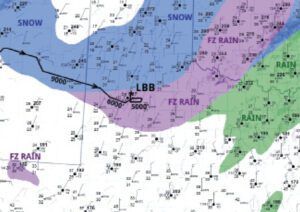
divert to Lubbock for “fuel considerations.” ATC controllers cleared him direct to Lubbock. As he crossed over the city he was given vectors for Runway 35L, but he overshot the approach fix. He was directed about 20 miles east. Flying at 5000 feet, he was in a cold layer and the airplane became thoroughly cold-soaked. Light freezing rain was falling from bands of overrunning convection.
As the aircraft flew a long base leg for the second approach, ATC asked the pilot if he was experiencing any icing. The pilot reported freezing rain with an outside air temperature of -10-degrees Celsius.
As the aircraft lined up for a 10-mile final over the city, ATC asked the pilot to check his altitude immediately, as he was below the minimum vectoring altitude of 5200 feet, and warned of an antenna tower at his 12 o’clock. The pilot reported he was just having problems with his autopilot. The ADS-B data recovered by investigators showed a slow decrease in groundspeed from 80 to 50 knots.
As these speeds fell below 48 knots, the Centurion pitched up, then entered a sharp descending left turn. The plane hit the ground near a house on E. 37th Street and was consumed by a post-impact fire. Witnesses on the ground reported that they had seen the airplane pitch up as if it were entering a loop, then entered a sharp dive.
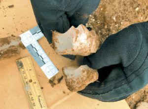
Investigators found thick concave-shaped chunks of ice that provided conclusive evidence that the airplane was downed by icing. Much of this ice was one to two inches thick. These shards littered the ground all over the crash site.
It was also found the cabin heat exchanger had pre-existing cracking, which allowed
exhaust gases into the cabin. A toxicology report reflected this, indicating carboxyhemoglobin in the blood consistent with carbon monoxide poisoning. This correlated with the pilot’s overall confusion and willingness to continue the flight, according to investigators. Three days earlier, during the previous leg from Nebraska to New Mexico, the pilot reported he felt sick during the flight. Whether the nausea, fatigue, and malaise were from carbon monoxide poisoning or from another cause puzzled investigators.
Summing It Up
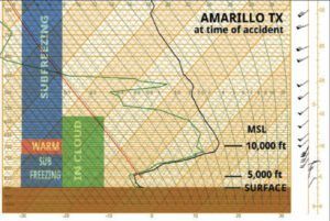
The Lubbock crash story can probably be summed up by the old saying, “Mess with the bull, get the horns.” The route took the aircraft directly into a deep area of IMC and subfreezing conditions caused by a fast moving cold front and abundant moisture from the Gulf of Mexico. Furthermore, the pilot elected to descend into an area where persistent freezing rain and drizzle was being reported. Presumably he anticipated warmer conditions at lower altitudes, but the Skew-T diagram clearly shows the worst of the cold air at 5000 feet MSL, right at the base of the precipitation layer. Altogether he spent 18 minutes loitering at 5000 feet in temperatures of -10-degrees C.
As a meteorologist, this is a classic pattern we all recognize for heavy icing. When you have an active frontal zone with significant layers of subfreezing air, coupled with a moist environment and warm advection, icing can get severe. The Skew-T diagram for our accident flight shows that above 7000 feet we find strong south-southwest winds bringing up tropical moisture that overruns the cold dome. This is much the same pattern that plagued the well-known American Eagle ATR flight that went down in 1994 in Roselawn, Indiana.
During my days as an Air Force forecaster, it was drilled into us in forecast training that freezing precipitation in METAR and Airways observations always indicates severe clear icing. This rule of thumb worked its way into surprise questions on our tests and quizzes, and this emphasis built upon decades of accident investigation board findings. The events on this day were no exception. Lubbock was reporting many hours of freezing rain and drizzle. A stout warm advection pattern with cold low-level conditions can produce massive amounts of supercooled large droplets (SLDs), and this can cause problems even for properly equipped aircraft.
Furthermore, a lack of freezing precipitation is no assurance that severe icing isn’t happening aloft. The type of weather pattern we’ve described is almost always one of warm moist air overrunning a cold, dry layer at the surface. In a sense, this precipitation can be imagined as virga, with strong cold, dry advection replenishing the lowest few thousand feet of the atmosphere, evaporating the precipitation and chilling the surface air through wet bulbing. Yet heavy precipitation and lots of SLDs continue to be manufactured at around 5000 to 10,000 feet above the ground. Relatively small amounts of it reach the surface, giving a persistent -FZRA or -FZDZ on the METAR reports. Only when cold, dry advection diminishes or mid-level precipitation intensifies further does heavier precipitation reach the surface.
So be alert to what’s happening in the clouds. Watch for large splatters on your windshield with subfreezing temperatures: these are SLDs. Ice buildup on the windscreen, side windows, and aft of protected surfaces are other good clues that things are getting dangerous. Your best option is an altitude change. Knowing a good target altitude requires a thorough weather brief or awareness of the weather patterns at hand.
In general, if the ATIS reports freezing precipitation and temperature-dewpoint spreads less than five-degrees F, it’s always going to be worse down below. In our example at Lubbock, the spread was only two-degrees F. Landing should only be an option if you can get down with no delay and observed precipitation remains light. If the outside air temperature is -10-degrees C or less, chances are very good that things will be better up above. You’ll either climb out of the cloud or reach colder layers that don’t support SLDs as well. If you’re in a bind, don’t hesitate to get help from controllers, as they can check around for PIREPs and perhaps get a forecaster in the loop.


