
Entering the dog days of summer, our attention shifts to the south. Rich moisture, weaker winds, and an increase in thunderstorms are classic signs that tropical moisture has entered the forecast equations. The media also becomes filled with headlines about hurricanes and tropical storms. And perhaps your cross-country trips even take you south to the tropical regions.
With these new weather elements, how can you stay safe while flying, and what hazards should you look for? We’ll cover that in this issue’s article by breaking things down, starting with the elements of tropical weather. By the time you reach the end, you’ll have a thorough understanding of how it works. A strange TAF in an unfamiliar location will no longer be such a challenge.
The Big Picture
First, let’s take a look at the big picture. Weather in the tropics is driven strongly by incoming solar radiation. The belt of strongest heating directly underneath the sun shifts north during the summer to the Tropic of Cancer, at a latitude of 23Åã26′ N in late June, then slowly begins its return southward.
The belt of maximum atmospheric heat follows this band, lagging by about a month, while maximum oceanic heat lags by about two months. The belt of atmospheric heat is marked by the Intertropical Convergence Zone (ITCZ), a zone of low pressure and “troughiness” in the atmospheric pressure field, with enhanced clouds and shower activity. Fortunately, the ITCZ does not affect North America proper, giving us one less headache to deal with. The closest it comes to our neck of the woods is the Central American countries and the Caribbean region.
However, the vast plume of invisible air that rises along the ITCZ day after day, spreading north and south, does affect the North American continent. Due to Coriolis force interactions, this massive plume of air accumulates in the subtropical latitudes, about 20 to 30 degrees north. Conservation of mass dictates that air piling up in the upper troposphere must be compensated by divergence in the lower levels. This produces a response in the midtroposphere consisting of sinking motion or subsidence.
The result is high pressure, called a subtropical ridge, and lots of fair weather. This explains why sunny weather is the rule in places like Mexico, Cuba, Puerto Rico, Florida, the Bahamas, and even the Sahara Desert. It explains why Honolulu has fewer rainy days than Omaha, despite its location on a tropical ocean. Likewise, in the Southern Hemisphere, the subtropical ridge is the direct cause of the aridity of the Australian outback, the Namibian Desert, the Atacama Desert, and the South African highlands.
Closely tied with the subtropical ridge are the oceanic highs. This includes the “Bermuda high” found in the central North Atlantic. Strong highs are also found in the Pacific between Hawaii, Alaska, the West Coast, and the southeast of Japan.
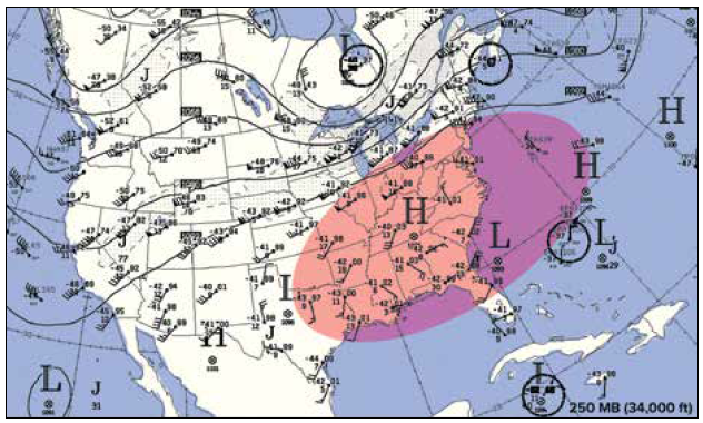
Other than those systems, pressure-driven patterns are very weak in the tropics. If you were to draw a conventional weather map here, you would find few isobars, and those that did exist would seem to wander randomly, defining weak low-pressure areas around bright sunny areas and weak high-pressure areas near clusters of rain. Only the subtropical highs would show a lot of isobars. This isn’t that useful for tropical forecasting, so many forecasters use streamlines, lines parallel to the wind flow, which are more responsive to weather systems in tropical regions.
At The Medium Scale
Let’s return to the Northern Hemisphere. While the big picture is dominated by the wandering ITCZ and subtropical ridge to the north, we find a belt of northeasterly winds in between. These are caused by surface winds flowing southward from the subtropical ridge back to the ITCZ. These winds turn to the right due to the Coriolis force, becoming northeasterly trade winds (blowing from northeast to southwest). If you’ve read up on history about the Caribbean or even played a round of Sid Meier’s Pirates! you know how well trade winds define this area.
Disturbances often form within these trade winds, disrupting the northeasterly flow and giving it a more wavelike appearance on weather charts. These disturbances are known as easterly waves. The wind convergence that develops within these waves produces zones of rising and sinking motion, with the result often being broken to overcast clouds and rain showers in and near these easterly waves. The waves move westward at about 10 to 15 knots and are often followed by a couple of fair weather days.
While easterly waves are most common in the Caribbean and Central America, we often find them as far north as Florida and the U.S. Gulf Coast region, especially in the late summer. Easterly waves are also a potent location for the formation of tropical storms and hurricanes. We’ll talk about those in a bit.
In some areas like the desert Southwest, we deal with the summer monsoon. Some of this was covered in the July 2021 issue (“Summer Patterns”), so we won’t go into too much detail here. However, monsoon winds are driven by intense heating deep in arid continental regions, wind flow that might not otherwise be here. So at Phoenix, Arizona, instead of light and variable winds as found in a subtropical region away from oceanic highs, we see a southerly wind bringing moisture from Mexico.
This attempts to spiral into the hot, buoyant air covering the Southwest states bringing several weeks of afternoon showers and thunderstorms.
The Local Picture
What we’ve described are all of the basic building blocks of tropical weather. Now we can build on this fundamental picture with one last layer of weather: the diurnal cycle and local wind circulations.
The diurnal cycle describes the daily process of the sun heating the earth’s surface. The earth’s surface heats the layer of air contacting the ground, and thermals rise, which grow into convective plumes. With enough moisture, these grow into cumulus clouds, and if conditions aloft are cool enough, these clouds can develop into showers and thunderstorms. Diurnal thunderstorms are always an afternoon and early evening phenomenon. Then, after dark, we’re left with convective debris clouds, scattered to broken layers typically between 5000 and 25,000 feet, which gradually dissipate during the night.
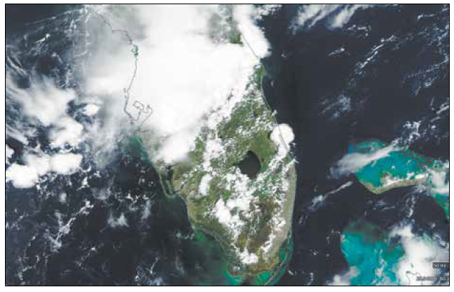
Many areas of the tropics are coastal, so the sea breeze is an essential local wind pattern. These form from the marine layer rushing inland in response to the strong heating of the land. The sea breeze moves at a speed from five to 25 knots and is stronger whenever there is a large temperature difference between the sea and the land.
The sea breeze produces clouds or showers and storms, depending on instability, that reach a maximum during the late afternoon. This is one of the reasons why you’ll have a lot of problems flying into Florida airports during a summer afternoon. Large lakes can also be another source of sea breezes. By anticipating the sea breeze, you can get an idea of the day-to-day weather and the active runway and local traffic pattern.
At nighttime, the reverse happens as cooling over the landmasses drives the boundary back out to sea at night. This process is nowhere near as strong as the sea breeze, but in some areas along the Gulf Coast, nocturnal thunderstorms offshore are a common occurrence.
Other local wind circulations might be encountered in the tropics, such as valley and mountain breezes. Much like the land and sea breeze, these are circulations that are overlaid on the prevailing flow.
Tropical Cyclones
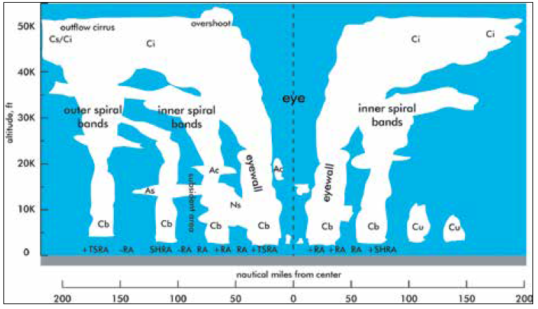
Tropical cyclones are a special class of weather disturbances found in the tropics. They include hurricanes, typhoons, tropical storms, tropical depressions, and even nondescript tropical disturbances. All tropical cyclones are powered by clusters of cumulonimbus towers fueled by warm ocean waters, releasing latent heat into the middle and upper troposphere. This lowers the pressure at the surface, encouraging winds to flow inward, converge, and produce upward lift. And yes, this is a chain reaction of development.
Fortunately, tropical cyclones are handled well by today’s global numerical models and are watched closely by the National Hurricane Center. So as long as you’re keeping tabs on the forecast from day to day, you’ll have plenty of time to relocate your airplane inland if a storm suddenly appears in the forecast.
While weaker systems don’t present much of a hazard to aviation, the spiral bands on the leading edge of many tropical cyclones contain lines of severe thunderstorms caused by the highly sheared environments that develop in this area. These can cause extreme turbulence, heavy icing, and all the other factors associated with thunderstorms. Also, it’s essential to be aware that even well inland, the rain area with a slow-moving, landfalling hurricane can be quite extensive and be even more hazardous to fly in than you might otherwise expect.
Visibility And The Tropics
The prevalent source of obscuration to visibility is, of course, fog. Radiational fog is by far the most common type of fog in a tropical air mass and is found mainly in areas where rains have occurred the previous day, followed by strong cooling under clear skies. These fog layers don’t grow very deep in the tropics and tend to be patchy, rapidly clearing with morning heating.
Haze is also common in the summer. For the most part, it occupies the lower half of the troposphere, topping out at about 10 to 15,000 feet in the atmosphere, with a clear blue sky above. A widespread misconception is that haze is tied to air from tropical latitudes. Sometimes hazy, humid air can arrive from the tropics, especially when forest fires or slash and burn activity pollutes portions of the tropics. However, stagnant, recirculated air trajectories from inland regions of the eastern United States have been identified as one of the leading sources of haze events. Consider that if the tropics were, in fact, hazy all the time, Caribbean cruises and beaches in Cancun wouldn’t be that pleasant.
A common occurrence during the summer is the occasional arrival of Saharan dust, which for North America mostly originates from the Sahel. This dust is not made up of sand grains but actually consists of nearly invisible microscopic clays. As the ITCZ shifts north into western Africa, thunderstorm complexes develop and can kick up vast amounts of dust. This is carried westward by the tropical easterlies toward the Caribbean basin over several days. From here, the dust either continues east into Central American and the Pacific, or bends northwest toward the United States, especially into Texas, Louisiana, and sometimes Florida.
When Saharan dust is present, visibility can fall to as low as three miles, regardless of the time of day. In sunlight, the air is tinged with a pale yellowish- brown color, while the sun itself appears as a pale yellow disc. The dust usually moves on after 24 to 48 hours and is concentrated mainly in the lower 10,000 feet of the atmosphere. Since Saharan dust has very high albedo, visible satellite images are useful for finding them. During dust events, you can find the plumes, most commonly in July and August, between West Africa, the Caribbean, and onward to the Gulf of Mexico.
Hazards
Finally, this brings us to flight hazards. These are mostly centered around precipitation areas and storms. These storms, like their springtime cousins, often contain wind shear and extreme turbulence. If you’re skeptical of the hazards from shear and turbulence around tropical thunderstorms, consider the crashes of the Pan Am 727 in New Orleans in 1982 and the Delta L-1011 at Dallas in 1985. These occurred deep within tropical air masses where wind shear was the cause. They appeared on July 9 and August 2, respectively.
However, icing can be a significant hazard in convective storms due to the very high amounts of supercooled water. Fortunately, with the high lapse rates and warm atmospheric conditions, the danger areas in summer are typically confined to the 15,000 to 20,000-foot band. Therefore, they do not affect most single-engine piston flights since they can remain well underneath. However, the dangerous icing conditions can be carried well above 20,000 feet in strong thunderstorms as large drops can be lofted to these levels by the updraft and may not undergo rapid freezing.
Many of your remaining hazards boil down to unplanned IMC. These will mostly be around the thunderstorm areas mentioned above, and on rare occasions, fog and Saharan dust will be one of those things bringing down visibility.


