
Summer is the ideal time to take the plane out and visit fly-ins, see some old friends, and seek out the hundred-dollar hamburger. It’s easy to fall into the mindset that wintertime hazards are gone, the turbulent weather of spring is over, and winds are light and variable. Mostly true, but there are still problems to consider.
What Is Summer?
We often think of this season as when the weather is hottest and the sun is highest in the sky. Meteorologists consider a more global view, seeing the sun moving northward into higher latitudes. By late June, during the summer solstice, the sun is at the zenith over the Tropic of Cancer, near 23.5 degrees N. This means at places like Houston, near 30 degrees N, the sun is within seven degrees of the zenith. The result is a gradual ramp up of strong solar heating.
Due to the strong heating, depressed barometric pressure, and wind convergence into this zone, a band of clouds and bad weather often follows this northward migration. Most of it remains in the tropics, where it is known as the Intertropical Convergence Zone, or ITCZ (which is not a factor in North America). But the deepening low pressure inland does lead to a seasonal circulation in which high pressure exists over the oceans, with air flowing into low pressure in the North American interior.
A powerful circulation that develops is the Bermuda High, representing the heightened pressure over the central Atlantic. It extends into the Southeast states, producing a persistent southerly wind in the entire eastern half of the United States throughout the summer months. In the Northeast U.S. this wind is normally southwesterly, while in the Gulf of Mexico and Florida, this wind is easterly or southeasterly.
Moist tropical air begins reaching further into the continental interiors as summer progresses. These moisture fields are often eroded once or twice a week as weather systems pass through, but the moisture eventually comes back even stronger. Dew points rise well into the 70s (F) in the Midwest, producing sultry, unbearable heat in places like Iowa and Indiana. This also has a big effect in the western United States, where moisture is not normally present. When this combines with the intense solar heating on rocky, sandy soil and sunlight-facing mountains, this produces extensive shower and thunderstorm activity known as the Southwest Monsoon.
Sea Breeze
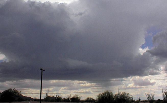
Sea breezes are quite active in summer, especially in the Gulf Coast region, the East Coast, and California. They’re often noticeable during quiescent weather patterns. These sea breezes begin moving inland during the morning, bringing a wind shift consisting of onshore winds through a relatively shallow marine layer. This marine layer measures only a few thousand feet deep.
If enough moisture is present, rain showers can begin developing along the sea breeze by late morning, with thunderstorms by afternoon. This shows on radar and satellite images as a scattered or broken line of precipitation aligned with the sea breeze axis.
When the sea breeze couples with prevailing winds from the same direction and the terrain is flat, sea breezes can travel quite far inland. In June and July it’s common for the sea breeze to reach Houston in the early afternoon and San Antonio, Austin, and Dallas by evening, bringing showers and a few storms to those locations as it passes. The sea breeze dissipates by dark and becomes impossible to find. The new sea breeze, meanwhile, develops again on the coast the next morning.
Southwest Monsoon
As we mentioned, the Southwest Monsoon is driven by an increasing influx of moisture into the desert Southwest where solar heating combines with rocky, sandy soil to produce extensive convection. These storms follow a sort of schedule, developing across West Texas, New Mexico, and Old Mexico in June. By July the monsoon begins reaching Arizona and the Four Corners area. Then in August, much of the Rockies, the Great Basin, and the California deserts are affected.
The best flying weather is in the morning. By midday, thunderstorms build on mountain peaks and begin moving into the valleys during the afternoon with the prevailing flow. Gusty winds in excess of 50 knots, blowing dust, and lightning are the main hazards. Tornadoes are extremely rare, though straight-line winds may spin up into brief gustnadoes. Hail is often found in the storm between 10,000 feet and 40,000 feet MSL and frequently falls on mountain summits, but rarely reaches the valleys as the low-level wet-bulb temperatures are warm enough to support rapid melt as the hailstones fall.
There are a couple of indicators we look for. When dewpoints are consistently in the upper 50s to near 60 degrees Fahrenheit (about 13 to 16 degrees C) from day to day, this is a good indicator the Southwest Monsoon has arrived. The Aviation Weather Center METAR page has good maps for looking over dew point temperatures. The monsoon is also enhanced by strengthened southerly flow. This happens when the subtropical ridge in the upper levels shifts east into New Mexico or Texas. The resulting southerly flow brings an increase in moisture to the Southwest region. Flight-level winds with a southerly wind component of over 20 knots at any level are a good indicator that the Southwest Monsoon may be active.
Great Northern Storms
Springtime brings severe thunderstorms to much of the Great Plains, along with an assortment of tornado outbreaks and large hailstorms. Things are not over in the summer, however; the storms simply move north with the shift in heating.
Although Texas, Oklahoma, and the Gulf Coast reach peak heating in late July, severe thunderstorms are not common. This is because much of this heating also reaches the upper troposphere, strengthening the subtropical upper-level ridge and reducing thermal lapse rates and instability. The shift in the jet stream to the north also means that it’s more difficult to create the type of shear and convergence needed for organized severe weather. The one exception is hurricanes, which provide exactly the kind of shear that is needed. Hurricane Andrew in August 1992, for example, produced 61 tornadoes across the Southeast states, one of them reaching F3 on the Fujita damage scale.
With the subtropical ridge shutting down most severe weather in the Southern Plains and Southeast states, the focus shifts to the northern states, anywhere along and north of a line from Kansas to Illinois to Maryland. Here spring never really stops, and the occasional unstable pattern, jet stream, and frontal system can produce severe weather anytime during the summer.
In the Northern Plains, places like Denver, Cheyenne, and Rapid City see an increase in thunderstorms, especially when easterly winds produce upslope flow that brings in layers of tropical moisture. Due to the overwhelmingly dry environment, forecasters see more soundings characterized as “inverted V” (try an online search to learn more). Because of this, microbursts are an especially significant problem. Large airports like Denver International Airport have a Low-Level Wind Shear Alert System (LLWAS) that helps provide another line of defense against problems from intense storms.
In the Upper Mississippi River valley, Great Lakes, and Midwest we see other types of storms. Many of these develop from storm complexes across the Dakotas, Nebraska, and Iowa during the day, which then move eastward during the evening. Normally they provide soaking overnight rains, which are a massive help for the agriculture industry in the Corn Belt. But in other situations with rich moisture, strong instability, and dry air aloft, they can organize into squall lines that move eastward across the Great Lakes and Midwest, often reaching the Northeast states.
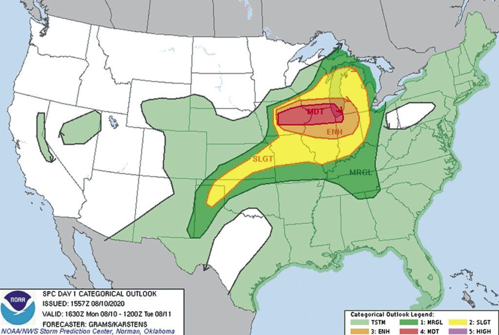
The worst storms are known as derechos, which produce footprints of severe wind damage where at least one axis (by width or length) measures hundreds of kilometers in length. One of the most damaging derechos in recent history occurred in Iowa on August 10, 2020. This storm produced winds of up to 140 mph and left $11 billion in damage.
The best way you can protect yourself from these squall lines, windstorms, and derechos is to check the Convective Outlook at the Storm Prediction Center or Aviation Weather Center. Whenever there is a slight risk or greater, this means you need to be on guard against tornadoes, hail, or wind. A marginal or general risk indicates a minimal hazard, but remember that storms can still be severe up in the flight levels: thus all thunderstorms should be treated as hazardous. As storms can form into large complexes unexpectedly, even against the indication of the best dynamical models, summer is the time to expect the best but plan for the worst.
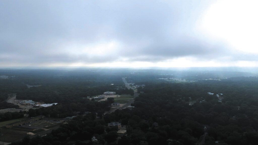
Fog and Stratus
The infusion of large amounts of tropical air into the United States as summer progresses means radiational fog and stratus become much more of a problem. The FAA Aviation Weather Handbook has a good rundown on radiational fog. The ideal setup is when the ground and foliage are wet from recent rains and strong radiational cooling takes place under a nighttime sky. If winds are stronger than about 10 to 15 knots, the fog is more likely to lift into a layer of stratus. This sort of fog and stratus is dispersed with strong solar heating.
Cold currents, such as those along the West Coast, and the cooler waters along coastal New England, are also prolific sources of low ceilings and reduced visibility. When the marine layer advances inland it brings pre-dawn and morning fog and stratus to many of these coastal areas. The Aviation Weather Handbook sections about advection fog are relevant here, including the statements that a pilot will notice very little difference aloft between radiation and advection fog, with advection fog being more extensive and more persistent.
Advection fog (usually as stratus inland) is common along the Gulf Coast and Southeast states in the summer when there is a strong pressure gradient and when inland conditions are unusually cool. Such stratus fields may reach hundreds of miles inland. Since this tends to be dynamically driven, it’s not all that different from the stratus we see in the spring.
In places like Washington and Oregon, surges of marine air masses can be especially strong and last for days. This is driven almost entirely by strong heating in the Great Basin region. Temperatures approaching 100 F in Kennewick, Spokane, and Boise, is a good indicator trouble is brewing. The flow becomes much stronger than normal along the coastal mountain gaps, and the Portland area, Seattle, and Willamette Valley become flooded with stratus and morning fog.
These marine surges or “marine pushes” will even try to cross the Cascades into the desert regions, but they are rapidly broken up by the intense heating as they cross the Cascades.
Density Altitudes
High terrain, hot temperatures (and to a lesser extent, high dew points) combine to produce higher density altitudes, often many thousands of feet above the actual airfield elevation. This can be a significant problem at airfields throughout the Rocky Mountain states. Even at a short airfield near sea level, you can quickly get into trouble. The NTSB database is full of accident reports due to reduced performance in warm weather, and it’s likely all of these pilots figured they would be just fine.
When you’re dealing with hot conditions along your route, expect degraded aircraft performance. Always run the numbers on density altitudes, runway length, and your aircraft weight if there’s any doubt. If it all looks good, you know that’s no longer a concern and can concentrate your attention on other problems.
Hurricanes
And finally let’s not forget hurricanes. They can occur at any time in the summer, but late July is the time to start monitoring things anywhere along the Gulf Coast and East Coast. September is peak hurricane season, and as a general guideline, the danger ends on Thanksgiving.
Fortunately the forecast tracks are accurate out to 36 hours and reasonably good out to 120 hours, so it’s unlikely you’ll get stuck in a storm unless you’re completely tuned out of social media and the news. The Hurricane Prediction Center is the place to go to find a full listing of all storms in the Atlantic and Pacific basins and find accurate tracks.
Let me add a word about the West Coast: No tropical storm of hurricane intensity has ever made landfall on the West Coast, at least not yet. But the arrivals of Pacific hurricane remnants are common events in Arizona, New Mexico, and in west Texas, and may affect southern California on rare occasions. These remnants bring lots of cloud cover, extensive bands of heavy showers, and areas of MVFR conditions. A good rule of thumb when I worked the forecast counter is to always assume there’s worse weather going on in hurricane remnants than it appears at first glance.
Tim Vasquez is an aviation weather forecaster, writer, and programmer. His interest started at age five after watching a spectacular squall line roll in, and by age 12 he was already learning Skew-T diagrams. You can find some of his forecasting books on his website at weathergraphics.com.


