Your flight is short—just over an hour. What could happen? A lot. Solid clouds can develop on the way and hunker down into low bases by the time you descend for the destination. If it’s misty underneath, visibility likes to swing from marginal to none. Well, that’s why missed approaches and alternates exist. Meanwhile, it could all burn off into a beautiful VMC day any minute. So if you decide to bank on that and rely on local weather reports, just know that they might lead you astray.
Fat on Fuel
From your home ’drome in Huntington, Indiana, near Fort Wayne, you fly regular trips in a club Archer to Bad Axe, Michigan, a rural area in the eastern thumb of the state mitten. KBAX, Huron County Memorial, is just an hour from home and gets you near the family cabin, surrounded by hunting and fishing havens.
This autumn trip will start out in CAVU darkness, then enter potentially misty but otherwise visual conditions. Unfortunately, while you were dreaming of a successful hunt, some thick clouds moved in and by 5 a.m. local, the AWOS-3 at KBAX was reporting 200-½. The airport is 16 miles from Lake Huron, but the shoreline fog can certainly spread inland as early morning progresses, like a shadow in reverse. No worries, you’ve got it covered. Depart at 6:00 (then cross into Eastern Time) and simply return home to the good weather if you need to wait it out some more.
But after seeing the low IMC covering a good chunk of eastern Michigan, you pause the preflight and decide to top off the tanks. Flint’s forecast hints at improvements to 800-5 in the next hour, providing a mid-flight escape route. To further support your decision to go, there’s a shoreline weather station included in the area METAR list that is up to 700-3. This one is actually a standalone National Weather Service station, appropriately named Port Hope. Surely those reports are a harbinger of better weather coming to the area in the next few hours.
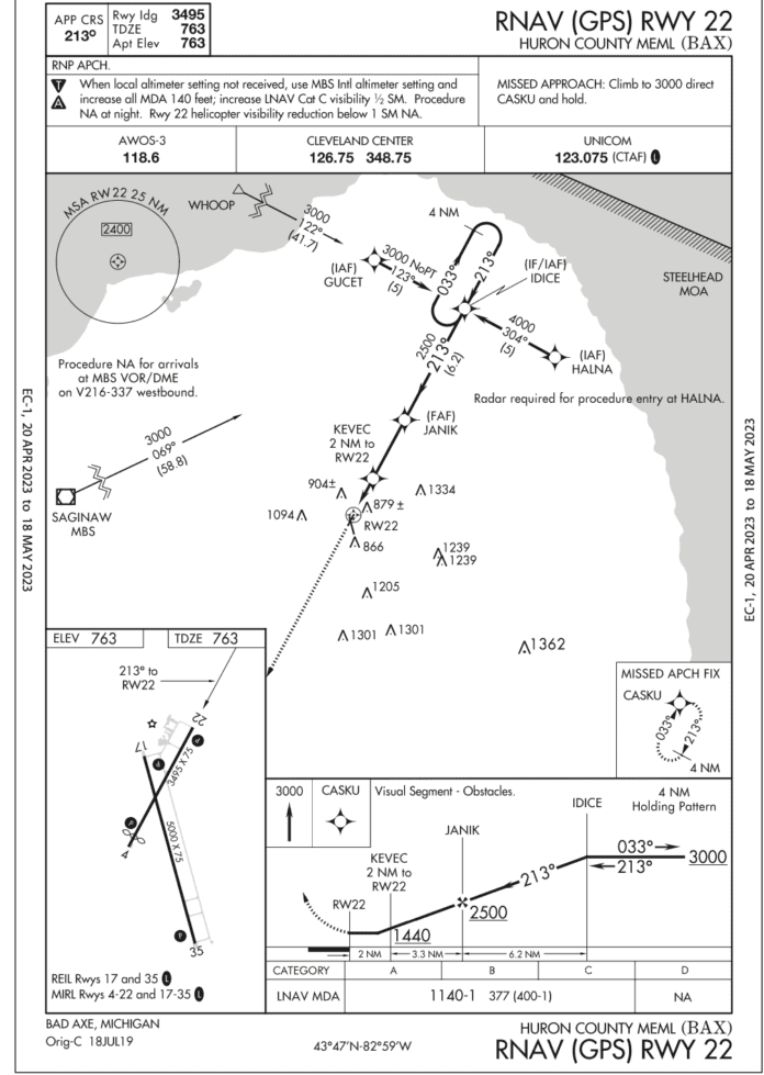
Meanwhile, Bad Axe has a great setup for its rustic location: Two runways and four RNAV approaches. The really nice addition is that each runway has a four-light PAPI on the left. The Archer is still LNAV-only, but since that’s the only approach available for Runway 22, you’re all set. Whenever possible, you opt for Runway 22 over 17 anyway for the shorter taxi to the transient parking ramp. Plus, LNAV-only minimums are also a bit lower for Runway 22 at 1140-1.

Your usual plan also includes filing the familiar alternate to the southwest—Caro, Michigan. But today it no longer qualifies as the alternate under §91.169(c) with 100-½ and you doubt it will improve to 800-2 to become a legal alternate. So you change your filed alternate to Saginaw, which has a TAF predicting 1000-2 after the top of the hour. You can still divert to Caro, of course, if the actual weather is up to minimums. And now that you’ve got over three hours of fuel, there’s oodles of time to fly two approaches at KBAX, and if it’s still not good enough, head to the alternate for an approach. You’re off Huntington just after 6/7 a.m. eastern.
Why the Miss?
Ten miles from your favorite initial fix, IDICE, ATC clears you for the approach. Coming in from the southwest, you’ll fly the hold-in-lieu-of-procedure turn to get established. For the last 20 minutes, the KBAX AWOS-3 on the second radio has steadily reported 500-3. So far so good; it’s near minimums with a small margin above the 1140-foot MDA.
At KEVEC, now at 1440 feet on a two-mile final, you expect to break out any time. But when the GPS distance ticks down to one mile from the runway and the altimeter reads 1200, you should see more than two NM if it’s reporting three statute miles. Where’s the runway?
This being a familiar procedure that you’ve flown in all conditions, you know that trees penetrate not only the 34:1 slope for a standard approach path, but also the 20:1 slope, triggering limitations including NA at night.
And even for the uninitiated, the note “Visual Segment – Obstacles” on the approach profile should be a big cue to refer to AIM 5-4-5, Instrument Approach Procedure (IAP) Charts. In part: i. “…There is no implicit obstacle protection from the MDA/DA to the touchdown point. Accordingly, it is the responsibility of the pilot to visually acquire and avoid obstacles below the MDA/DA during transition to landing.”
And: k.1. “…When the VDA/TCH is not authorized due to an obstacle penetration that would require a pilot to deviate from the VDA between MDA and touchdown, the VDA/TCH will be replaced with the note ‘Visual Segment- Obstacles’ in the profile view of the IAP … Accordingly, pilots are advised to carefully review approach procedures to identify where the optimum stabilized descent to landing can be initiated.”
Indeed, if the reported visibility was supposedly above the legal minimum to continue under §91.175, you might want to have a good view of the ground leading to the threshold and not just some lights to continue. The power’s already full forward and it’s an easy straight-out climb to 3000 feet, after which you again check the AWOS: 400-2. Obviously, you got lulled into assuming (hoping?) the AWOS would match what you see, but in a couple of minutes it had gotten worse. Yet you continue hoping it’ll reach MDA for real.
Another Go
Before reaching the missed approach fix to the southwest, you ask Center for vectors back around to the RNAV 22. This time, you get faint ground contact after the final fix, JANIK, but see little improvement otherwise. The AWOS says it’s back up to 500-2. At KEVEC and at 1500 feet, there’s the PAPI and the first set of runway lights. (There are no end lights on 22.) Two white, two red, great. But without asphalt and paint in view, your brain just wasn’t happy not having the trees in sight at 1200 feet so again you go missed.
Still no worries; you’re flying these perfectly, everything’s running fine, and the tanks plenty of fuel. But you fell for the AWOS trap again. You oughta take it for granted by now that actual in-flight conditions and the automated reports will differ. But instead, you still assume the opposite: What it says is what you get (400 feet! Keep going!) When it’s this tight, that dependency on the numbers droning in your headset is strong. However, this reporting, while updating as often as twice a minute or more, reports ceiling from where it sits, and not a mile away. Advisory Circular 150/5220-16E strikes again. (See a brief reference to this in the June 2023 IFR Clinic.)
There’s still enough fuel to fly another and make an alternate, but your limit is two. And fatigue is getting the best of you, mostly from the early departure followed by this low-IFR stuff. The first approach yielded an indefinite ceiling as far as human vision goes, with poor vis below. The second had better conditions, but not enough for a comfortable “visual segment.” You’re done here and heading to the alternate. Caro is up to 600-3. Thankfully, it’s a nearly straight-in approach from present position: Keep going southwest right to RAYOL to pick up the RNAV 24 from there. Thirty minutes later, refreshed and refueled, you are tapping out a new flight plan for KBAX. By the time the clearance came, Bad Axe reaches 1000 scattered with visibility up to five miles.
The Trap
That’s more like it. In hindsight, you did prepare well in terms of flexible timing and alternates, so you needed to use all the backups because you also built in a trap. That was by taking a familiar approach with obstacles that you usually fly in better conditions. It wasn’t really meant for low minimums and so it turned into a second “attempt” to get in by relying on a single point of weather data. Great that you stuck to your personal policies and never came close to worrying about fuel, but in reality you didn’t have the endurance to match the airplane’s. Still, you get extra credit for resisting the urge to continue below MDA—and for topping off those tanks.
Elaine Kauh is a CFII in southeast Wisconsin, where there are plenty of IFR alternates for all those misty, cloudy mornings.


