
You’re the owner, operator, and chief (only) pilot of Totally Legal Charters, flying passengers between the Hawaiian Islands and making questionable decisions. Pick whatever single-engine sim plane you like and base it at Kalaupapa (PHLU).
Today’s weather is good enough for some sightseeing, barely, but poor enough that you’ll fly IFR—you know, just for safety. The news said something about a hurricane, but this is Hawaii, where they’d call it a typhoon if it mattered to you, right?
Getting Started
Set 3200 overcast, visibility three SM in light rain. Surface winds are 270 at 10 knots and 220 at 35 at 4000 feet.
Your first leg is a short hop to Molokai (PHMK) to pick up passengers. Your GPS hasn’t been working—the screen is dark. Luckily, your “mechanic” at Molokai says he’ll fix it quickly with the right hammers and such.
Depart PHLU Runway 23 on a departure procedure; climb to 4000. Fly to MKK VOR for the VOR or TACAN-A and land. Get your GPS fixed.
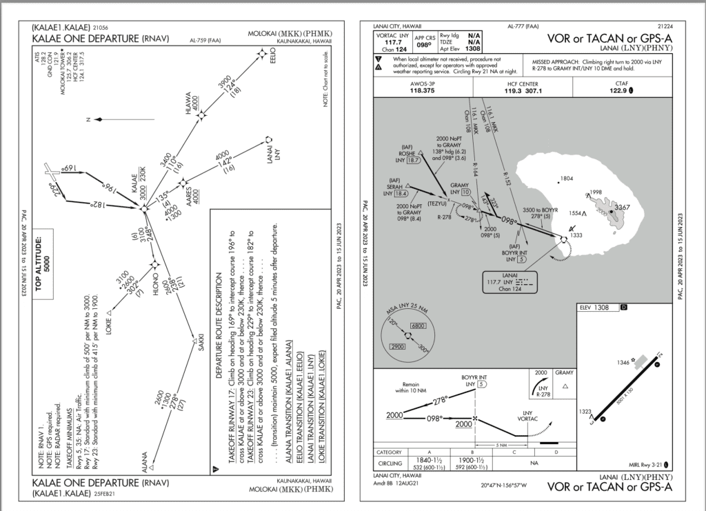
Your first passenger-carrying leg is Molokai to Lanai (PHNY). Your clearance is via the KALAE1 Departure, LNY transition, “climb via the SID, except maintain 4000.” Do that, and request the VOR or TACAN or GPS-A. After all, it’s the quickest approach from your direction, the minimums are acceptable in today’s relatively good weather, and if your GPS goes dark again, you’ll be fine. At AARES you get direct ROSHE for the approach. Maintain at or above 2000 until established. Change to advisory, and plan a circle to land.
Unfortunately, upon reaching midfield downwind, you learn that the student pilot doing pattern practice flew a short approach to beat you to the runway, botched it, and collapsed the nosegear. Fly the missed as published, and tell ATC you’d like to divert to Kahului (PHOG). Your passengers probably won’t mind. They’ve had enough Mai Tais that they probably won’t even know the difference.
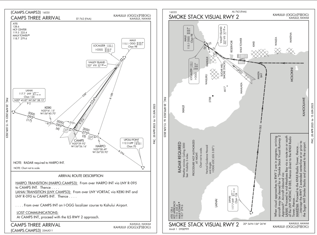
ATC tells you to climb to 5000 and fly the missed as published, with your clearance on request. After a lap in the hold, you’re cleared to Kahului via the LNY VOR and the Camps Three Arrival. Maintain 3000. Passing KEIKI ATC gives you a change of plans to get some fast military traffic ahead of you on the ILS. You get the published hold at CAMPS at 3000.
After a turn in the hold, ATC asks you to confirm you’re in visual conditions and asks if you can accept the Smoke Stack Visual Runway 2 to save some time. You say yes, because time is money even though you can’t see much more than ocean and some distant cliffs. You’re cleared for the Smoke Stack Visual Runway 2 approach.
Assume the capable controllers work you and those faster jets to the runways without issue. Land, taxi to the FBO, drop off your passengers, and grab some lunch from the vending machine. You’ve got another sightseeing flight this afternoon and the weather is only getting worse. But if you just stay low over the water…
Leg 1: PHLU-PHMK
Which departure did you chose out of PHLU, why, and how did you fly it?
There’s no textual ODP—you’re told, “Use Kalaupapa One Departure.” That’s a charted ODP, which is fine except it takes you pretty far out over the water (further if departing Runway 5). Read carefully and you’ll see there’s also a Visual Climb Over Airport (VCOA). A VCOA avoids obstacles by climbing over the airport in VMC.
Lacking specific departure instructions, you can fly the VCOA, but you must inform ATC. This one also requires at least a 3200-foot ceiling and three SM visibility … conveniently what you have today. The ceiling requirement makes sense—you can’t climb visually in the clouds. VCOAs usually terminate above the airport at a certain altitude, from which you continue to climb in any direction in IMC to a safe en-route altitude. Maybe you knew all that and chose this VCOA, but did you catch the extra bit: Upon reaching 3100 MSL you must “proceed on the MKK R-057 to MKK VORTAC.” Luckily, that’s over land too.
How close to the airport do you need to stay on a VCOA, in order to be protected from obstacles?
That’s a trick question. VCOAs don’t protect from obstacles. They define a space where you maneuver visually to see and avoid them. VCOAs include weather minimums enabling just that. The area surveyed for VCOAs depends on turning radius at the fastest plausible groundspeed (usually 250 knots) and a 23-degree bank angle. It’s generally well over three miles, although a smaller radius can be stipulated. They also don’t have climb gradient requirements. So as long as you stay basically over the airport as you climb, the VCOA will set you up to be safely on your way. Don’t be tempted to fly a VCOA in IMC using the GPS. You could hit something if you can’t see it.
Which way did you turn on the departure? What frequency(s) were you monitoring?
It is technically VMC, so it’d be best to fit in with pattern traffic. That’s left turns for Runway 23, the only one for which the VCOA is authorized. If you flew the Kalapapa One, a right turn would have been correct as that’s the direction on the procedure.
Monitor both CTAF and 121.95. “But wait,” you say. “Center is on 124.1.” True, but the Sectional shows a warning about tour aircraft reporting on 121.95. Always look at what VFR targets might be doing even when you’re IFR. Of course, that’s moot if your dark GPS screen returned, preventing you from tuning multiple radios.
What minimums did you use on the VOR or TACAN-A? Would this approach have any advantages over the RNAV (GPS)-B?
Without a real DME, not WUBAL minimums. Your GPS may substitute if the screen works. The plan view shows why you need to identify WUBAL to go lower—it’s to ensure you’re past the mountain. This approach also avoids an unnecessary over-water segment if you don’t need the lower MDA.
Did you spot the runway?
The weather is certainly good enough, but if you missed the subtle eight-degree bend at the FAF, you might’ve also missed the airport. If you’re used to an auto-slewing electronic HSI, it’s easy to forget old-school techniques like twisting the OBS knob on a traditional VOR indicator. Another retro tool is needed to identify the missed approach point: a timer. Forget both, and you’re flying the wrong direction until you realize your mistakes.
Hopefully you managed the circle-to-land. The high circling mins mean you probably needed to descend earlier than you would in a normal downwind. Once below MDA, obstacle avoidance is again an eyeball job.
Leg 2: PHMK-PHNY
What does it mean to “climb via the SID except maintain 4000?”
This SID has altitude restrictions at KALAE and AARES: at or above 3000 and 4000, respectively. Those are in play if your clearance specifically says to “climb via the SID.” (Note that the altitudes along each leg are MEAs, not restrictions.) So here, you should cross KALAE at or above 3000, and AARES at least at 4000. Normally, you’d climb to the published “Top Altitude” of 5000, but the “except maintain” in the clearance indicates you should level at 4000. When you hear “except maintain,” think “except amend the top altitude to…” Not the clearest wording, but it’s what we’ve got.
If your GPS didn’t work, how would you fly the leg from ROSHE to GRAMY?
It’s a dead reckoning (DR) leg, so you’d simply fly a 138-degree heading until intercepting the inbound course. You could try correcting for wind, but in theory the procedure accounts for that and provides a reasonable intercept even in the worst-case wind scenario. It’s simple here though, as the GPS treats DR legs like any other leg.
Did you see the runway on this one?
At least you have the GPS to provide course guidance, but you’d better have studied the chart to know where the airport is. Nearing the MAP, the airport is over a mile away at 9 to 10 o’clock. That’s not a normal place to look for a runway. Then there’s the intimidating cliff appearing ahead out of the murk, just a few hundred feet below. Just the black (or magenta) line isn’t enough—you need a sense of the lay of the land.
How did you handle the missed approach?
You’re well past the missed approach point or course, so you need to get creative. The AIM says to first make a climbing turn toward the landing runway and the heart of the protected circling airspace. Then you should join the missed approach course. Here you probably needed the moving map to fudge your way back to the magenta line. Solid positional awareness for the win again, in that almost any direction other than northeast takes you over lower terrain and the ocean.
If you’d completed the circle, watch out for the common base-to-final overshoot trap set by the low altitude and high groundspeed on base leg.
Leg 3: PHNY-PHOG
How did you fly the CAMPS THREE? How could you do it without a GPS?
It’s pretty trivial with a GPS going waypoint to waypoint, although the hold at CAMPS won’t be in the flight plan. Without GPS you’d be using VOR and the hold would be DME from LNY or an intersection of the VOR and the localizer. Identifying KEIKI without GPS would require … an ADF.
How was the transition from the Camps 3 to the Smoke Stack Visual? How did you decide when to turn northbound toward the airport?
The CAMPS uses LNY R-095; the Smoke Stack requires you to stay south of R-085, so you started off okay. So long as you stayed on or south of R-085 until halfway across Malea Bay, you’re good. In low vis, you could take a hint from the Sectional and tune R-188 off OGG (V1-17) or just watch for a bearing of 008 to the airport on your GPS.
Did you catch any errors the controller made?
3000 feet is below the first MEA on the CAMPS THREE. If you descended immediately, you’d have had a close call with a 3367-foot mountain.
Which runway did you use at PHOG?
The visual was to Runway 2, but a quartering tailwind isn’t much fun. Did you get tunnel vision and land that way in the sim? Tower would probably have set you on a downwind to Runway 20 or 23. Hopefully, you did that for yourself. That said, landing with a small tailwind is sometimes a necessary IFR evil.
Maybe that’ll be a theme for a future Sim Challenge.
Ryan Koch and Jeff Van West both dream of flying in Hawaii someday. Considering they live in Wisconsin and Maine, respectively, these dreams happen from pretty much late October until early July.


The VOR or TACAN A into Molokai was very challanging for me with out GPS. It was hard for me to judge how far out from MKK I was to know when to do the procedure turn to give me enough time to get stable on my in bound course and altitude. I finally went out to LOKIE. Thoughts on a better idea?
Flying IFR without GPS is hard. That is why I have a GDL for my IPAD as back up.