
About the time this issue arrives, the U.S. will be heading toward the tail end of summer 2020. In just a matter of weeks the U.S. will begin its slow spiral into winter. While training material and aviation weather books are full of information about winter flying, along with its hazards like icing, CAT, and visibility restrictions, what problems lurk during the transition season? These issues aren’t often discussed.
As an IFR reader, the odds are pretty good that your flying takes you into less-familiar parts of the country. A one-size-fits-all view of the weather just won’t work. It makes sense that we break things down by region, giving you a better understanding of the peculiarities of different regions. This is one article you might want for reference when you have a cross-country trip coming up.
Northwest Region
The Northwest region covers Washington, Oregon, Idaho, and adjacent parts of British Columbia and neighboring states. Meteorologically, it’s bounded by the Klamath Mountains and Great Basin on the south, and the Rocky Mountains on the east. It is also divided by the Cascades,
a chain of mountains extending, from east of Seattle and Portland southward to Crater Lake.
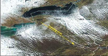
The Cascades divide the region into two very different subregions. West of the Cascades are the cities of Seattle and Portland. Weather here is dominated by the Pacific Ocean and its cold currents. IMC is common, along with frequent precipitation. I can think of nowhere in the country where it’s more vital to check TAFs when inbound. On the other hand, the Cascade Range forms such a strong divide in the air masses that when an airport on one side is below minimums, you can often find a suitable airport on the other side. This might not work in the winter, though, when radiation fog becomes a problem inland.
West of the Cascades, the worst weather is produced when there is a deep coastal frontal low, especially along the Oregon coast. This pattern is usually associated with an approaching warm front. The strong pressure gradients can produce gusty winds, strong turbulence, and low ceilings. For those who remember the famous footage of “Galloping Gertie,” the Tacoma Narrows Bridge, being destroyed in 1940, it happened in this sort of weather pattern with a deep low moving up the coast.
East of the Cascades are high deserts, arid valleys, and the Great Basin, and important cities like Spokane, Boise, and Salt Lake City. Weather manifests as elevated forms of what’s happening west of the Cascades, with lots of overcast altocumulus and cirrus. During the fall, high pressure often builds into the region as migratory weather systems move west to east. This clears things out and ushers in periods of good weather.
Southwest Region
The Southwest region covers California, Nevada, Arizona, and most of the Four Corners area. For forecasters, it starts at the Pacific Ocean and extends to the Rocky Mountains along the Front Range and Sangre De Cristo Mountains of Colorado and New Mexico. It includes southern portions of the Great Basin area.
Fall is a quiet pattern for this region, and brings some of the best flying weather of the season. Early in the fall, weather patterns are dominated by the large, semipermanent heat low usually anchored in western Arizona. By November as
landmasses cool, the dominant weather feature becomes the cold high-pressure region in the Great Basin area of Nevada and Utah. For example, southerly winds prevail at Las Vegas most of the year, but northeast winds dominate in December and January.
The coastal regions are a special problem. During the summer, a cold marine layer caused by cold currents and upwelling overlies the ocean along the West Coast. As this region is dominated by a large, warm subtropical high, we find a “warm over cold” atmosphere here. You might recall that this constitutes a stable environment. A semipermanent inversion caps the marine layer, and just below this inversion we find extensive stratocumulus and stratus layers, sometimes accompanied by fog.
During periods of hot weather, a thermal circulation develops between the cool coastal areas and the warm buoyant San Joaquin Valley and interior deserts. As a result, the low clouds along the coast invade coastal valleys and move some distance inland, mainly at night. This can bring airports like LAX and San Francisco down to IMC. Morning heating usually burns off this fog and stratus, and it dissipates or recedes westward by afternoon.
Late fall brings frontal systems approaching the northern California coast, particularly during El Niño years. These cause extensive areas of rain and low ceilings, and in the Sierra Nevadas, the appearance of winter weather. These systems leave extensive ground moisture and are followed by high pressure, a potent recipe for nighttime fog in the San Joaquin Valley.
The bowl shape of this terrain makes it difficult for this fog to clear out until high pressure leaves the area and a pressure gradient returns. Fog and stratus can persist for days, especially in the late fall, bringing down visibility at places like Bakersfield and Fresno. It’s a good idea to make sure you have your alternates in order when flying into this area in the fall, especially towards November and December.
South Central Region
The South Central region extends from the Rocky Mountains to the Mississippi River, covering Texas, Colorado, Kansas, Missouri, Arkansas, Louisiana, and adjacent parts of Colorado and New Mexico. It covers all of the southern Great Plains as well as the Ozark Mountains, and includes airports like DFW, Oklahoma City, and Houston.
This region sits on a battleground between warm desert air in the interior of Mexico and the Southwest states, cool air from the Pacific, frigid air masses from Canada, and humid, sultry air from the Gulf of Mexico. As a result, the weather here is temperamental, especially in the autumn months.
During August and September the pattern is usually hot, with plenty of VMC. However some summers are marked by a southward shift in the jet stream, or an unusually active “Hudson Bay vortex” pattern. When this happens, outflow boundaries are driven south into Oklahoma or north Texas, sparking cycles of thunderstorm activity each afternoon that move southward. If you see stationary fronts hanging around the area on the weather charts, or a jet stream further south than normal, expect this kind of pattern.
During October, a series of strong cold fronts begins sweeping through the region. Some are Pacific in origin, approaching from New Mexico; others are Canadian in origin, arriving from the Northern Plains. Both of these fronts are capable of triggering thunderstorms and bad weather. Clearing and northwest winds usually follow in their wake.
The pattern that produces the most widespread IMC occurs when these fronts pass through Texas and stall along the Gulf Coast and the Rio Grande. When this happens and there are strong pressure falls in the Rockies, Gulf moisture is drawn northward over the cooler air. This produces extensive stratus and fog, and brings ceilings down to at least about 2000 feet during the day and 500 feet at night. The pattern can persist for multiple days until high pressure clears things out.
North Central Region
The North Central region covers everything from the Rocky Mountain foothills eastward to the foothills of the
Appalachians. This includes the northern Great Plains, as well as the Midwest, along with Minneapolis, Chicago, Indianapolis, and Cincinnati.
The weather here is strongly dominated by cold Canadian air masses approaching from the northwest, typically from
Alberta or Saskatchewan. These tend to be dry, producing sharply cooler weather. There’s typically not much impact on aviation except for some clouds and low-level mechanical turbulence.
Some systems originate from the Pacific, passing through Nebraska or Kansas. These are much more prone to producing IMC and lines of severe thunderstorms. Icing is a significant hazard around frontal systems, especially north of warm fronts and around deep low pressure areas. Now is a good time to review training material on icing.
Another hazard is lake-effect clouds and snow. This problem peaks in November and is caused by rather cold Canadian air masses passing over the relatively warm lake waters. It produces an unstable “cold over warm” situation in the lowest mile of the atmosphere and causes heavy snow and convective clouds on the leeward side of lakes onto adjoining coastal areas.
This is what causes much of the poor weather in places like Erie, Cleveland, and Grand Rapids. Lake-effect clouds can take ceilings down at places like Chicago, Milwaukee, Green Bay, and Detroit when the winds are out of the northeast.
Northeast Region
The Northeast states include, as you’d expect, all of the Appalachians, the Adirondacks, New England, and the Boston-Washington Corridor. It extends from Virginia north to Canada.
The weather here early in the fall is controlled by the large Bermuda High, which puts the region under a warm,
humid southwesterly flow. However, through much of the season, fast moving frontal systems begin passing through the region every several days. This brings an abrupt change to westerly or northwesterly winds and much cooler, drier weather. The humid southwesterly winds return, and soon another front approaches.
Hazards here are limited mostly to the showers and thunderstorms along these fronts, and the rather predictable areas of low ceilings and fog along the warm fronts. Icing is a major hazard along warm fronts and near frontal lows. Heavy rains followed by clear skies, compounded by strong radiational cooling, often produce widespread overnight fog in the Northeast.
Lake-effect overcast and areas of snow, like in the North Central region, can extend far inland from the Great Lakes, affecting airfields in western New York, western Pennsylvania, and northeast Ohio. This problem gradually subsides by winter as the lakes chill and partially freeze.
Southeast Region
The Southeast region spans all of the United States from the Mississippi River to the Atlantic Coast, from Tennessee and North Carolina southward. As you might expect, the Gulf of Mexico is a tremendous influence on the weather here during all seasons.
The primary hazard in the Southeast states in the fall is hurricanes and tropical storms. These peak in September, near the time of maximum ocean temperature in the Northern Hemisphere. The region is always under the threat of hurricane activity during the months of August, September, and early October. It’s not just the storms that make CNN headlines that you need to worry about; it’s also the tropical depressions that plague coastal areas for days. This is when you want to visit the NOAA National Hurricane center website as part of any extended flight planning. The risks drop during the month of October, and become negligible by late November.
The outer spiral bands of well-developed hurricanes, particularly on the right-hand side looking down the forecast track of the storm, are prone to developing intense, fast-moving embedded supercells. This is particularly true with hurricanes making landfall, where frictional effects and modest surface heating augments the strength and rotation of storms. These hurricane supercells can produce damaging turbulence, along with numerous but brief tornadoes on the ground. In-flight radar is essential for avoiding them.
As a rule, destruction from a typical Category 1-2 hurricane rarely reaches more than 100 NM inland (200 NM for a major hurricane). However these storms can produce torrential rain, reduce visibilities to less than ¼ mile in
rain showers, and produce extensive low ceilings covering a wide region, even as weak remnants hundreds of miles from the coast. The sheer amount of water vapor carried with tropical storms is astronomical, so don’t underestimate the potential for inflight hazards. Due to the extensively stratified, heavy precipitation fields, icing is a problem around tropical cyclones, particularly in the 15,000 to 25,000 feet band (and lower later in the season).
Tropical cyclones aside, the Southeast Region shares many of the same characteristics as the South Central region in the fall. Numerous cold fronts begin reaching the area in September and October. Many of these early pushes of cold air don’t have enough strength to reach the Gulf of Mexico, and the fronts stall out and become quasistationary. This can produce multiple days of overcast and low ceilings.
Strong cooling and abundant ground moisture also provide a rich environment for fog and stratus, especially after
recent rain. This plagues airports in the southeast U.S. during the fall; ceilings and visibility are often slow to improve.
Be Safe
Hopefully, this article provides you with a framework for understanding forecast problems across the country in the autumn months. In turn, this will give you more insight into the TAF and the flightweather forecast. In short, the fronts, highs, and lows will tell you where there will be bad weather, but the air masses and weather regimes are what control the fronts and the highs and lows. Always focus on the big picture, and you’ll be on top of the game.


