
We spend most of our IFR lives wrapped in the warm cocoon of radar coverage, vectored from point to point by the all-seeing presence of ATC. And while controllers are human and occasionally make mistakes, the checks and safety nets in place rarely result in close calls, let alone bent metal. It’s also true that when clearances get tight in the final descent to the airport, responsibility is handed over to the pilot.
Except when it isn’t. Consider the LOC Rwy 6 to Shreveport, LA (KSHV) and the note “RADAR REQUIRED.” Requirements stated in the plan view and not the approach title mean the requirement is for something other than the final approach segment. Here radar can play at three different levels.
Asking for Help
Without ATC radar, you can’t even start this approach. Note that there is no initial approach fix (IAF). There is no “full-procedure” for the approach. GIGGS is an intermediate fix (IF), and ATC procedures allow vectoring an aircraft to an IF to commence the approach. Without a published IAF, the only way to commence this approach is, “fly heading XYZ and join the localizer.”
If you’re flying /G or /A aircraft, you can take it from there. Each stepdown and the missed approach point (MAP) are DME distances from the localizer antenna (I-MWP). Although if your /G was a WAAS GPS, you’d probably fly the RNAV (GPS) approach to the same runway as it has lower minimums.
The plan view note refers to entry from (or exit to) the enroute structure. You need radar to get on the approach. However, the notes section in the briefing strip says, “DME or RADAR Required.” This note applies to the approach itself. If you’re /U, you’ll happily note that the final approach fix at DODDY shows “RADAR” in the plan and profile views. ATC can tell you when you’ve crossed this fix, after which you can descend from 2000 to 700 approaching WOXAT. ATC could also call crossing GIGGS, but the profile view shows you’ll likely be at 2000 outside of GIGGS anyway.
ATC won’t automatically call crossing DODDY just because you’re filed /U. You must request the service. Simply ask in plain English, “Shreveport Approach, antique Mooney Two Six Delta. We’re an impoverished /U aircraft. Would you call crossing DODDY for us?” Or something like that.
Be sure to start your timer right away, and use the first line of minimums on the approach chart. WOXAT isn’t notated with RADAR, so ATC can’t help you step down the extra 80 feet. ATC also can’t call crossing the MAP. Officially, you must identify the MAP by timing.
Real-world, we’d have our tablet with its unapproved GPS showing our position as well. Whichever one, timing or the tablet, said we were at the MAP first, that’s the one we’d use. One more safety net would be to put the localizer for the crossing runway in the number two nav. If that needle swings through, you’re definitely past the MAP and need to start climbing, now.
Another Option
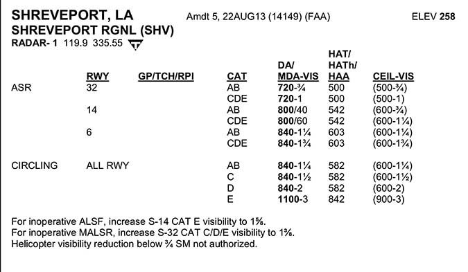
Actually, there is a way ATC can call your MAP at this airport. The letters ASR appear in the notes section below the inverse A and T for non-standard alternate and takeoff requirements. ASR stands for Airport Surveillance Radar, and means you can fly an approach to this runway with nothing but a transponder and a radio.
Radar minimums are published with approach charts, and appear with the other approaches as several digital pages in most tablet EFBs. Airports appear alphabetically, so you’ll flip to S for Shreveport. Find the runway you want and read the MDA and visibility requirements from the list. For Cat A and B aircraft landing Runway 6, that’s 840 feet and 1 1/4 miles vis.
The request to ATC is for the, “… ASR approach Runway 6.” ATC will vector you as with any other approach, but rather than instructions to intercept the final approach course, you’ll get one more heading aligning you with the runway. That’s 060 in this case.
When you cross the FAF, you’ll be told, “X miles from Runway 6. Descend to your minimum descent altitude.” From this point on, ATC will simply call your heading as seen on the scope, and your trend. A good call would be, “Heading 060. On Course.” A bad call would be, “Heading 050. Rapidly going left of course.”
You don’t need to acknowledge these calls. The controller sees the results of your labor on the scope right away. This is also a great time to watch your track over the ground, even on a portable tablet display. ATC’s calls of your course is your primary navigation source. There’s nothing wrong with using unapproved tablets to help ensure you get the “good” calls.
At some point, either you report the runway in sight or the controller tells you you’re over the MAP and should go missed. If you’re way off course, the controller can call that missed early with something like, “If unable to proceed visually, execute missed approach.”
That missed is also by radar vectors back in the skies and straight into a, “say intentions.”
The March of Time
Controllers are allowed to give GPS-equipped aircraft clearances direct to IFs with certain restrictions. There’s no practical reason that couldn’t happen here in lieu of radar guidance to GIGGS, and policy has changed such that “RADAR REQUIRED” on approaches like this will be replaced by “GPS or RADAR Required” as approaches are updated.
We’re told by our friends in Oke City that eventually all the approach notes will appear in a dedicated area of the briefing strip, outlining exactly what equipment is required for what part of the approach and why.
Until then, you’ll have to work it out on your own, ask for what you need, and, of course, keep a mental picture of how it’s all playing out to ensure the all-seeing eye didn’t get distracted at the wrong moment.
Jeff Van West knows he’s requested too much when he gets holds with an EFC of “right after the next shift change.”


