
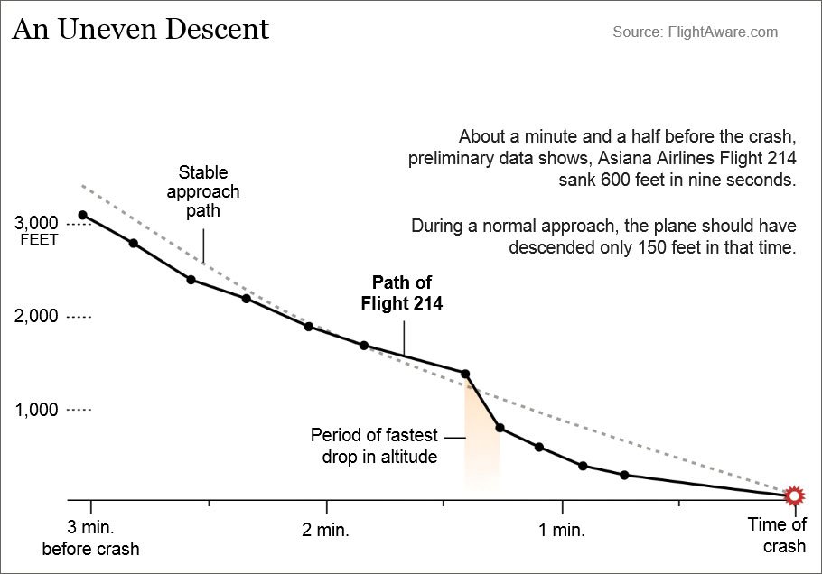
Visual approaches have been in the news a lot recently. On July 6, Asiana Airlines Flight 214 hit a seawall short of San Francisco’s Runway 28L and crashed. The flight had been cleared for a visual approach to Runway 28L. The ILS was out, but the PAPI was in service, so there was some vertical guidance.
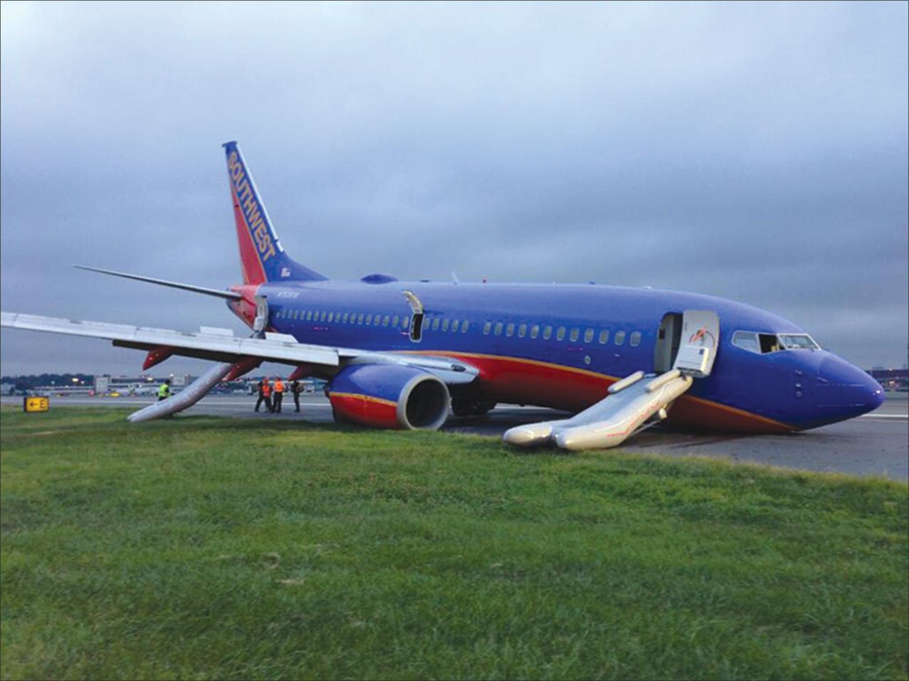
Later that same month, a Southwest Airlines Boeing 737 landed nose-wheel first on a visual approach at La Guardia. The nose gear crumpled beneath their feet, making the B-737 far more difficult to steer.
Ironically, pilots don’t train much for visual approaches once we get our Private. Responsibility lies partly on the instructor community, and indirectly the FAA. After all, we made you into instrument pilots. We train full instrument approaches, but visual approaches get short shrift. They are not even mentioned in the Instrument Practical Test Standards. Questions regarding visual approaches on aviation blogs reveal misunderstandings and false assumptions.
There is nothing casual about a visual (or any) approach, as Asiana and Southwest starkly remind us. A Flight Safety Foundation study reveals that 30 percent of approach-and-landing accidents occur on visual approaches. The risk skyrockets to 70 percent at night with reduced visual cues raising the specter of visual illusions and spatial disorientation. Sure, you landed visually as a mere student, but perhaps it’s time to refresh old skills.
The Rules
A clearance from ATC for a visual approach is ATC permission for an IFR aircraft to fly visually—clear of clouds—to their intended airport. This is an IFR procedure conducted under IFR in visual meteorological conditions. It is not an instrument approach procedure; therefore it lacks a missed approach segment—more on that in a moment. The specific 91.155 cloud clearance requirements don’t apply to Part 91 operators. (Certificated commercial operators may have tighter requirements.)
To start a visual approach you need—wait for it—visual conditions. The obvious way to verify visual conditions is the airport ATIS, AWOS/ASOS or METAR. Lacking a report, a forecast can be used, or the pilot can simply report visual conditions. No matter how you get it, the “visual” requirement in visual approach is 1000-3 at the airport.
ATC is allowed to vector you down through the muck for a visual approach only if the reported ceiling at the airport is at 500 feet above the Minimum Vectoring or Minimum IFR Altitude with 3-mile visibility or better. So, there may be cases where a visual can be flown (1000-3) but you can’t be vectored for it.
When a visual approach is in use, like any approach, you’ll generally be informed to expect it on your initial contact, the point at which you also confirm that you have the weather. If you’re landing at a remote or seldom-used airport, you might also volunteer that you’re planning for a visual, so everyone’s on the same page.
ATC needs you to report the airport in sight. If you volunteer, “Airport [runway] in sight,” that’s a common hint that you want and are ready to accept the visual and can maintain VMC to do so. Officially, you can call the airport in sight any time, whether or not there’s an operating control tower. Reporting the runway in sight is assumed by ATC to be for an airport with an operating tower. In practice, though, this distinction seems lost on both sides of the mic.
If you don’t volunteer that you see the airport, ATC will point it out and ask you to report it in sight. If there’s another airport nearby, ATC might also provide that airport’s location. This helps avert a too-common error where pilots, even at the airlines, might successfully fly a visual approach and landing at the wrong airport.
Like any approach type, the visual can be declined. This should be done thoughtfully, though. Since visual approaches streamline traffic flow for ATC, it might require a delay to sequence you for an instrument approach procedure.
ATC can clear an aircraft for a visual approach once the pilot has the airport in sight. Subsequent traffic, though, need only see the preceding traffic. At some busy airports in marginal conditions, this creates the amusing specter of an aircraft officially following the aircraft that has its preceding aircraft in sight, that has its preceding aircraft in sight…that has the airport in sight. All of these follow-the-leader aircraft are properly on a visual approach, even though the last one could be 30 miles out in three miles visibility.
Before ATC can clear you for the visual, it has to resolve any traffic and potential wake turbulence conflicts. With visual conditions, this is usually accomplished by pointing out the traffic and telling you to maintain your own visual separation. If you don’t spot the traffic, ATC retains separation responsibility. This includes preceding traffic on final that you might be overtaking, so speed restrictions are common.
At airports with an operating tower, ATC may clear you for a visual approach to one runway even as other aircraft are performing IFR or VFR approaches to parallel, intersecting or converging runways. These parallel operations are typically explained in the ATIS broadcasts.
Cleared for the visual, you become responsible for navigating to the right airport, staying VMC and avoiding obstacles and terrain. This can be difficult when cleared from many miles out, down low, where visibility ahead may be restricted. Consider using the DIRECT GPS function to help. Better still, use OBS mode and set the inbound course to the runway you plan to use, or if there’s an approach to the runway, simply use that for situational awareness.
In practice, visual approaches happen to be far more common at large airports than at Smallville Muni. When we’re flying GA into smaller airports, we tend to request and fly an instrument approach procedure if the weather requires it, or simply cancel IFR and land visually in good weather. We simply don’t need that middle option.
Large commercial operators, though, prefer to remain under IFR, even in severe-clear. So, for them, the visual approach is perfect. We’ve previously pointed out in these pages that airlines almost always set up for and essentially fly an ILS, even on the visual. The controllers know this, too, and more than once an airliner having to go around on a visual approach has been told to “fly the published missed” even though there isn’t one for a visual approach.
That’s technically incorrect but you hear it. Even if you’re ready with a missed approach procedure, you should clarify or just get a heading and altitude.
If a go-around becomes necessary at a nontowered airport, remain clear of clouds and land as soon as possible or contact ATC again for further clearance. ATC handles an aircraft unable to complete a visual approach as a go-around and provides IFR separation while you figure out what to do next—perhaps a full approach or a diversion.
Note that a visual approach clearance doesn’t cancel your IFR clearance. Similarly, ATC might tell you “Change to advisory frequency” at a nontowered airport, often adding “Radar service terminated,” although the last part is not required. Neither cancels your IFR clearance. Only the magic words “Cancel IFR” from you can do that.
Stabilized Visual Approach Tips
A visual approach is the end of an instrument flight. One hallmark of skillful instrument flight is stability. We just don’t go messin’ around in the clouds, yankin’ and bankin’. Thus, the best visual approach is flown with the same care and attention to smooth, stable operations. But, since it’s conducted in VMC, visual approaches often get a lower consideration for being properly stabilized.
Lack of stability on a visual approach often is a result of getting rushed. That makes the best plan to remain ahead of the airplane, same as you’d do for any approach. There are many seemingly obvious tips to avoid that last minute rush, but we’ll go through some of them because even the most accomplished pilots get behind the curve.
Obtain airport weather as soon as possible to decide if a visual is feasible and which runway is likely in use. Ask for lower as necessary so you can land normally. Use the standard gradient of 300 feet per nautical mile to be at pattern altitude three miles out. Descent at 300 feet per nautical mile loses 1500 feet over five miles and puts you three miles out at about 1000 feet. Remember to include obstacles and MVAs into descent planning.
Think about the wind. How will it affect your pattern if you’re not straight-in, and how will you need to compensate? You don’t want to find yourself on a close-in base-to-final turn, being blown across final by a strong crosswind that was even reported. Envision that wind, knowing it’ll increase your groundspeed on base, and start your turn to final early.
Balance the convenience of a visual approach against the ceiling and visibility, darkness and weather such as wind and turbulence. Are you experienced with the airport and what’s around it? Are there any visual aids such as VASI, PAPI (VGSI) or approach lights?
At least three miles from the runway threshold, have the airplane configured to land, with appropriate power settings and your briefings and checklists done.
At night, if an approach is available, fly it. For every visual approach, set up navaids for the IAP associated with the landing runway. This lets you monitor and be ready if visual references are lost.
A visual approach is not necessarily straight-in. Fly a close-in pattern to a defined altitude or a CVFP if available. Review the airport’s surrounding terrain, hazards and obstructions from any NOTAMs. Avoid banks over 30 degrees.
Turn base with approach flaps and gear down. Resist the temptation to fly a circling descent to the runway. As the VGSI comes into view, begin adjusting altitude before you turn final. Make crosswind corrections to arrive on final with the requisite drift correction.
The graphic to the left shows Asiana 214’s approach was not stable. Being stable means using available references and being wings-level on final, aligned with the runway and on approach speed by 500 feet AGL. It also means remaining on the correct flight path with only small heading/pitch changes, and on a reference airspeed between 1.3Vso and 20 knots faster.
Groundspeed variations suggest wind shear. Use an ILS or VGSI to avoid getting low. Descent rate should not exceed 1000 feet per minute. An approach that remains—or worse, becomes—unstable below 500 AGL even in VMC is cause for an immediate go-around.
You’re Unstable If…
Your approach is too steep. You are too high and/or fast if you need a descent rate above 1000 feet per minute. If you’re below the glidepath, you’re too low, “dragging it in.” Fix that before 500 AGL.
You might intercept final too close. Perhaps you turned base too soon. Failing to correct for crosswind makes the final unstable, leading to excessive maneuvering. Your worst offense while unstable might be to make a late go-around decision or none at all.
Some pilots don’t know how their airplane decelerates when level or on a three degree glide path or they just hope to magically get stabilized by 500 AGL.
Visual illusions can cause you to unintentionally change the flight path to keep things looking right. Searching for the airport or visual references led more than one of us to divert attention from the airplane, risking hitting the ground.
Two Asiana pilots were grounded and given desk jobs. The Southwest captain was fired. Respect the visual approach and fly it carefully. It’s an instrument procedure, requiring precision and stability, even though it’s conducted in VMC.
Charted Visual Flight Procedures
CVFPs reduce noise over congested areas and provide a measure of traffic separation, while safely providing more efficient flow. CVFPs usually begin about 20 nm from an airport with an operating tower.
CVFPs follow the same general rules as ordinary visual approaches, but stricter weather requirements may apply. Approach charts show prominent landmarks, courses and altitudes. Pilots can be cleared for a CVFP with the airport, a charted landmark or preceding aircraft in sight.
Navaid information is merely supplemental. Depicted altitudes are provided for noise abatement or other airspace clearance. If required landmarks are not visible at night, the procedure won’t be authorized at night.
One well known CVFP is New York La Guardia’s Expressway Visual to Runway 31, so-named because of its route over the Long Island Expressway. Pilots and passengers both like it—pilots for the visual skills required and passengers for the great views.
It’s a fast, highly visual approach. The only published altitude is at DIALS. Jets begin descent just south of Coney Island, fly the LGA R-225 until they pass two white tanks about five miles from LGA. There the pilot turns hard right to follow the expressway, bringing them about a mile east of the airport.
Gear down, flaps set, at about 800 feet a hard left descending turn bends over Flushing Meadow Park around Citi Field. Done correctly, the jet rolls out straight in at about 300 ft AGL. All in a day’s work. —FS
Fred Simonds is a Gold Seal CFII, check airman and factory-certified G1000 instructor. See his web page at www.fredonflying.com.


