
Harvey Field in western Washington State (S43) is one of those almost mythical GA wonderlands. Cloth-clad antiques trundle down a runway that requires mowing while skydivers pack a careworn Caravan for just one more jump. Views of both can be enjoyed from the windows of on-field caf.
At least, that’s the way it used to be. It’s been a while since I’ve had the pleasure. Since I’ve frequented the field, Harvey has also stepped into the digital age with its own GPS approach. But like the fuel gauges on my buddy Dave’s Harvey-based Globe Swift, it’s an imprecise thing.
In fact, it’s a downright odd-looking approach for something starting with the letters “RNAV”—which should be a clue to anyone flying it that there’s probably more going on here than meets the eye. Perhaps literally.
Hook a Left on Final
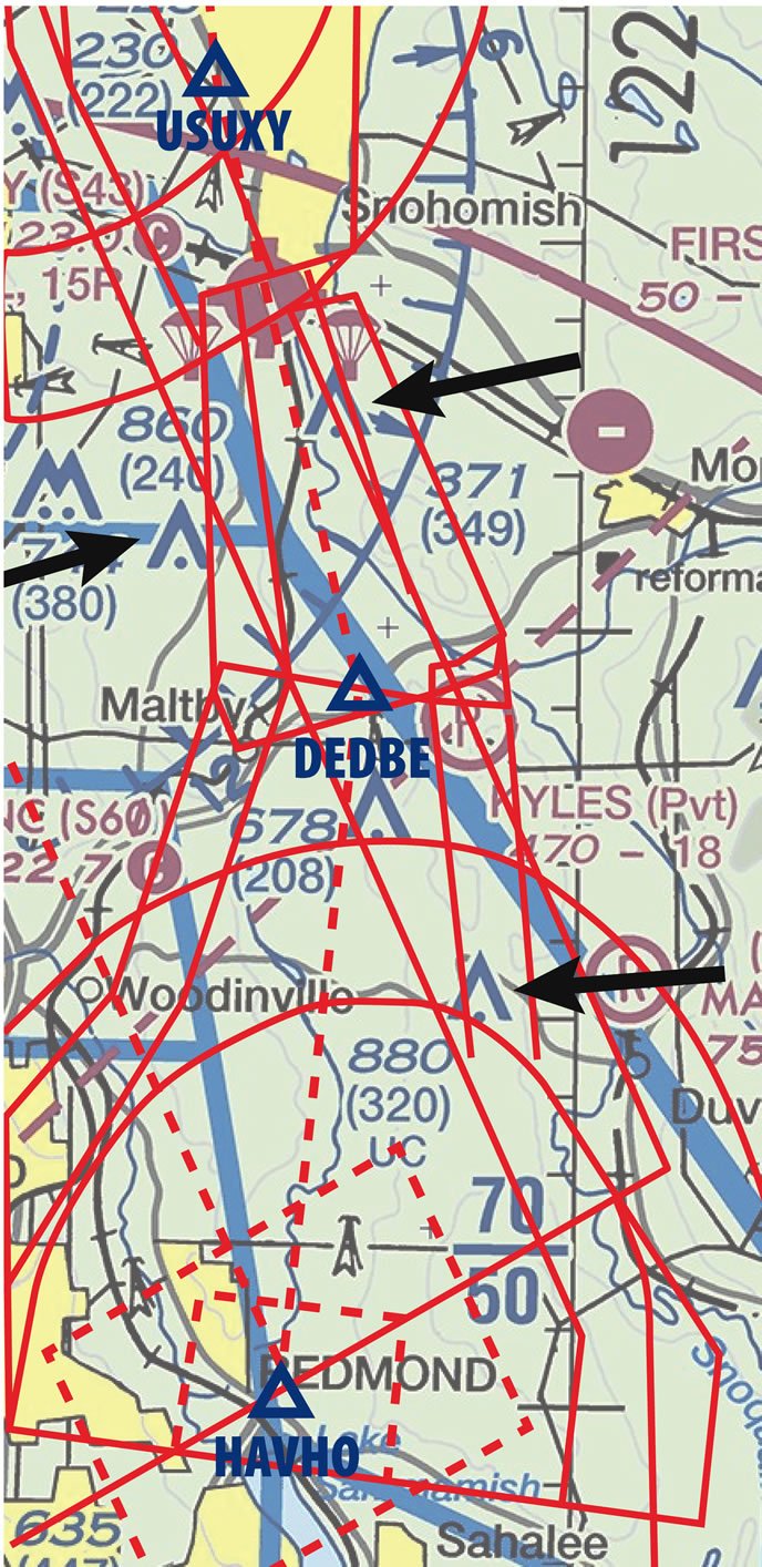
The approach starts at HAVHO, from whence aviators follow a 350 course to the FAF at DEDBE. Then it’s a 22-degree left turn to line up with Runway 33R, which is the paved one at Harvey.
Making a turn at the FAF isn’t desirable when it comes to approach design, so there must have been a good reason. However, there’s nothing that says the designers need to tell you what it was. Given that this airport lies in a valley between two mountain ranges, the first guess would be terrain. Looking on the approach plate, your only clue to that is the highest obstacle marking, which is drawn in bigger numbers than the rest of the obstacles. Here it’s the 3580 on the far right of the chart. Note that there’s no tower symbol, so this is terrain.
That terrain and the hills leading up to it—not shown on the chart—may be why the designers didn’t take the more logical approach (so to speak) of putting HAVHO further east and creating a course of 328 all the way from the IAF to the threshold.
It’s also possible that 880-foot tower on the intermediate leg had something to do with it, because it would be directly below if that leg aligned with the runway. In fact, our contact at the FAA verified for us the tower was the culprit more so than terrain.
Thread the Needle
The ideal final approach segment should align with the extended runway centerline. That happens here because DEDBE conveniently falls in the empty space between three towers. Getting to DEDBE on a 328 course would put that 880-foot tower under what’s called the primary area of the approach.
That’s a trapezoidal area protecting the approach course. Obstacle-clearance requirements are more stringent here, and would necessitate a high intermediate segment and a steep descent after crossing the FAF at DEDBE.
By bending the course, the designers could put that tower just barely into the secondary area flanking the east side of the intermediate segment from HAVHO to DEDBE. The standards relax a bit for the secondary area, and the intermediate segment altitude can lower. Take a look at the graphic to see how the tower is now right on the border of the primary protected area.
The designers probably looked at making the entire approach a straight path with no bend but that didn’t align with the runway so well, such as making the entire approach on a 340 heading from HAVHO. But that move would have put the towers at 860 and 740 feet now to the west of the final approach segment into a primary area, raising the MDA.
Did the same thing happen to create the bend on the missed? Did the 304-foot tower require a leg to USUXY before heading for the missed approach holding point at WATON? Are they trying to tell me something by calling the missed approach waypoint “You Sux?” Probably not, at least on the first two points.
That tower is still probably in the primary area, but too low to be an issue. More likely is that putting the published missed at WATON (a localizer outer marker at a nearby airport) was an ATC request to place the hold at a fix already in use for this busy airspace near Seattle. WATON didn’t quite align with climbing straight off the runway on the missed, so it’s straight and climbing until USUXY, and then a little turn for direct WATON.
Only Circle?
Speaking of climbing straight off the runway, this approach only shows circling minimums, which is why it’s the RNAV (GPS)-A rather than the RNAV (GPS) Rwy 33R. Having the final approach segment not aligned with the runway heading is the best-known reason for only publishing circling minimums.
Clearly that’s not the case here. So that leaves the question of why there are no straight-in minimums?
The second-best reason for no straight-in is too steep a descent gradient on final approach. But we fixed that with the dogleg approach path. The profile view shows the decent gradient as 3.67 degrees—steeper than normal but not prohibitive for a straight-in.
The reason here was again something you can’t see: runway paint that isn’t there. The field has non-standard runway markings. Given that it’s only a 36-foot-wide strip of pavement, it’s probably not possible to paint it with all of the requisite official markings. The grass runway is wide enough, but the paint probably won’t last long. (No, sorry, mowed patterns don’t count as official runway markings.) Circling minimums must consider obstacles for all runways, so the surveyed area is bigger and the minimums are higher.
Summing all that up, investigating a little bend on the approach points out terrain, obstacles, an extra step on the missed and a non-standard view on a narrow runway if you’re lucky enough to break out.
And if you are lucky enough to break out and land, find out for me if the caf is still there, will ya? I’m always up for a good airport breakfast.
Jeff Van West writes and teaches many things aviation and non-aviation related. Four of his favorite words are: “Breakfast served all day.”


