
Last month’s Clinic took us to western Kentucky where we wrangled a circling-only VOR-A approach. In September, we untangled an ILS/GPS hybrid in upstate New York. For another take on a ground-based approach using GPS, plus a circle-to-land, we head to Alpena, Michigan on the shore of Lake Huron. The lake’s a frequent source of low-level clouds that often arrive at inconvenient times to obscure useful things like runway thresholds.
We’re (barely) equipped for RNAV, with a basic GPS approved for en-route and terminal navigation. To sweeten the deal, the on-field VOR (APN) is out of service and Runway 7/25 is closed. With a 15-knot breeze from the south, Runway 19 is best, but the VOR and RNAV approaches are NA. Not a big deal; the 1500-foot ceiling works to descend via the ILS 01, break out and coordinate with the tower to fly a downwind for 19. This seems like a good plan, except…
Finding Fixes
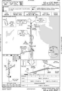
We’ll arrive on Victor 45 to the Alpena VOR, keeping in mind that halfway to Alpena we can’t switch over as we would normally. Instead, we’ll turn to the GPS flight plan, which includes WHOOP to TUSYU to AILES. AILES is our IAF leading to the ILS course inbound.
Keeping with the (barely) equipped nature of our GPS, the database is six months old. Current data is the best and safest way to operate, but the AIM provides a workaround. Table 1-1-6 (shown below) says our IFR (no approach) GPS must have “verification of data for correctness if database expired.” Since our tablet data is always current, we can easily compare—after confirming that our GPS flight-manual supplement doesn’t supersede and require current data.
Second missing piece: The fine print says “ADF required.” FELPS is the FAF for the localizer version, which we won’t need. But it’s also the missed approach holding fix, which we do need. Per that AIM guidance, it’s generally acceptable to use GPS for navigating to or holding over a VOR, NDB or compass locator. Since FELPS is 7.3 DME from the Alpena VORTAC, we can triple-confirm.
Missing MDA
Passing WHOOP at 5000 feet we coordinate with ATC for vectors. We spot an encouraging break in the clouds. But checking KAPN weather, it’s lower near the lake: 900 scattered, 1600 broken, with vis down to two miles—too low for a visual. How about a circle? Sure, the ceiling’s plenty high. Unable, for yet another missing piece: no circling MDA. Must be the nearby obstacles. With a 9000-foot runway, we’d consider landing downwind, but there’s too much tailwind today.
We’re comfortable flying a pattern as low as 700 feet AGL. (We practice that, a lot, at home.) Just make it a left downwind due to obstacles just west of the localizer course. To circle from an approach without circling minimums, the options are: 1) wait for better weather and cancel, 2) use Special VFR, or 3) get a contact approach. Whatever the choice, coordinate well in advance. If the tower’s closed, which it might be, coordinate intentions with Minneapolis Center. (Alpena Approach and Tower operate from 8 a.m. to 4 p.m. local time as services come from the Guard base there.)
The first option would be ideal—if the weather’s better than 1200-3. This isn’t a visual approach from the IFR rulebook; it’s VFR in Class D airspace (or Class E if Tower’s closed), which requires flying 500 feet below the clouds with visibility at least 3 miles.
The other alternatives eliminate the cloud separation and visibility margins, so check Option 2: Switch from an IFR descent to Special VFR and all we need is a mile and clear of clouds. Terrain/obstacle clearance is up to us, but we can choose our own course to Runway 19, using the localizer for situational awareness. We’ll get to stay in the system longer, so SVFR isn’t of much benefit. While useful to sneak past local fog, it’s easy to break VFR regs (unless in Class G, typically from the surface to 700 or 1200 feet AGL, you can’t already be in one-SM visibility before getting SVFR).
Contact It Is
A contact approach affords us the protection of the IFR system without flying a full IAP. We can top it off by circling at our discretion, maintaining one mile visibility and clear of clouds. Again, coordinate ahead of time as the pilot must initiate the request and communicate intentions for what amounts to a DIY approach. Do this before AILES so ATC is prepared.
We’ll get cleared for a descent to AILES, start the contact approach there, and continue descent to perhaps 2000-feet MSL, to get below the overcast at 1600-feet AGL and remain above the scattered clouds at 900 feet AGL. Fly the localizer for course guidance and obstruction protection, then sidestep to the left downwind for Runway 19. Get below the scattered layer when possible with a descent to our DIY 700-foot pattern altitude. We’re still responsible for terrain and obstacle clearance, but we do get separation services from IFR and SVFR traffic. Another advantage over SVFR is that we don’t need the airport in sight to get cleared. We only need an expectation that we will see it in time to land.
We’ll be sure to discuss missed approach instructions beforehand. Tell ATC we’ll fly the published missed if still on the localizer. Northbound on the left downwind, it’s logical to follow the published missed: A climbing left turn to 2800 feet, and head to FELPS. If on final for 19, we must make sure it’s safe and OK with ATC to miss by flying runway heading—better yet, the LOC BC—straight for the fix. Otherwise, get instructions. And, if conditions allow, it’s fine to continue to fly the left pattern or simply circle over the airport.
Just so we’re also in tune with the regs, see what the Instrument Procedures Handbook has to say on these considerations: any (emphasis added) “published missed approach procedure provides obstacle clearance only when the missed approach is conducted on the missed approach segment from or above the missed approach point, and assumes a climb rate of 200 feet/NM or higher, as published. If the aircraft initiates a missed approach at a point other than the missed approach point, from below MDA or DA (H), or on a circling approach, obstacle clearance is not provided by following the published missed approach procedure, nor is separation assured from other air traffic in the vicinity.”
On the contact approach, we can maneuver wherever we deem safe: “Unless otherwise restricted, the pilot may find it necessary to descend, climb, or fly a circuitous route to the airport to maintain cloud clearance or terrain/obstruction clearance.” That’s a lot of flexibility around and over the airport as well. Just watch for obstacles, watch and listen for VFR traffic, and use “normal maneuvers” as prescribed in §91.175.
All things considered, getting into an airport without the typical published procedure opens up a lot of discretion on the PIC’s part. We get to decide the route of flight, the minimum weather to make it work, and even the set of rules we want to use. As long as we meet the regs and play it safe, we can find good solutions to even challenging puzzles.
Elaine Kauh is a CFII in eastern Wisconsin. She enjoys working out puzzles that explore the fine balance between legal and safe in near-impossible situations like this, but her actual flying is far more conservative. She urges extreme caution to any pilot pushing the edges of the envelope like this.


Great article re approach to Alpena one question shouldn’t you be below the clouds when you initiate the contact approach? One mile and clear of clouds?
Love that this article got me pawing through the FAR/AIM (as I’m sure was your intention, thanks!); concerned that I feel like I should change my tail number and file an ASRS report simply because I read it. Yipes!
Elaine, I don’t mean to single you out. I am sure you are a capable flight instructor with the best of intentions, but I will ask you to consider the implications and tone of your articles, as I fear ultimately it does a disservice to the GA community.
We are incredibly privileged in this country to be able to have essentially free access (with a few rare exceptions) to the unparalleled civil aviation system of the US. Almost everywhere else in the world there are prohibitive fees and regulations of all sorts, and thus virtually no GA activity. Let us not take what we have for granted, and I feel like ridiculous horsing around like what your article depicts only jeopardizes our freedom to work within our NAS. ATC is working hard to ensure the safety of hundreds of airliners filled with hundreds of souls every day, in addition to coordinating complex military operations, the extent of which most of us will never even comprehend. The last thing they need are a bunch of entitled flivers gumming up the works trying to outsmart the regulations. I know you merely are working out puzzles, but please consider how much unnecessary strain your hypothetical situation put on ATC. And, for what? And perhaps young pilots reading your article are led to believe that this is a reasonable way to approach flying. Because, it’s not.
Quite frankly, your phrase “the fine balance between legal and safe” makes no sense. But, I understand what you are trying to say, and I like it even less. As an author of a GA publication please consider your duty to convey to the readership our sense of appreciation for the privileges we enjoy as GA pilots, and find a way to inspire us to better our knowledge without conveying a sense of entitlement. I would never ‘tell’ ATC anything, except if it were an emergency or a near collision or to report another issue of safety of flight, like icing, and I would convey the information when it was convenient for them (notwithstanding an emergency, of course.) I would ask you to convey more of a, “let’s not get in the way and let’s follow the rules.” attitude, which I believe will have a positive effect on the perception of the GA community in the eyes of the public, ATC and the FAA.
You see, we don’t have a right to fly, ATC doesn’t have to issue us clearances, and showing gratitude and a healthy respect for the authority and the spirit of the rules will only work to help to ensure that we don’t wind up like most of the rest of the world: not many single-engine pistons up in the air.
Thanks for taking the time to read this and for writing to help educate, guide and inspire us pilots!
Kind regards,
Will
Interesting timing for the re-publication of this article, noting the recent LearJet accident at KSEE. Much has already been written and speculated about that accident, but it is definitely a warning to anyone considering circling / cancelling IFR / contact approaches, etc.
The conditions at KSEE were reported VFR at the time with broken clouds above circling minimums
Elaine thanks for your terrific article combining the essential elements of rules and safety. Articles like this are wonderful for understanding why the rules exist and how to interpret them to improve safety, not cut corners.
Elaine the regulation requires that there be both one mile flight visibility and one mile ground visibility. Your article fails to expound upon this but your example has a control tower and visibility reporting. Next time you revisit this issue please provide at least two uncontrolled examples; one meeting this requirement and one failing to and for which no pilot should request and no controller approve the approach because not having reliable ground visibility should definitely impact that “reasonable expectation of continuing to the airport “.
Specifically, I’m based out of S50 Auburn, WA. It lies cozily 9 NM SE of SEA beneath the 3000 class B shelf and just 2 NM from class B to surface and an 1800 foot shelf. It has no visibility reporting of any kind and pilots are requesting and receiving contact approaches because neither they nor the controllers are familiar enough with the requirements. Minimum circling altitude is 920 feet if flying the RNAV (GPS) A. Nevertheless, a colleague of mine and his student were at 800 feet 1 NM from the threshold and 300 feet 4000 feet from the threshold last Saturday around 4:30 pm in limited visibility and low ceilings. I met him for lunch today in an attempt to intervene. He said that he wasn’t aware of the ground visibility requirement. Presumably, he will stop doing these here. Basically, he as maneuvering and banking over the hangars to line up and land on the last third of the runway. I was stunned. Felt like I was watching an air show.
His last track plot reveals he’s at 100 feet upon entering the airport property at 550 right of the runway centerline.
In what world is that okay?
Really we don’t have a right to fly, the government works for us we don’t work for them. I get sick and tired of seeing people write like the government is our parents and listen or you will get scolded, they are a million laws and everyone breaks some everyday so don’t be on your pulpit preaching to others nobody wants to hear you.! What have you ever done to make things better.