
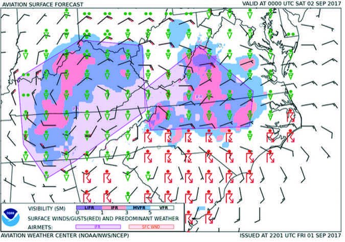
Chances are you’ve looked at that table of precipitation types in aviation meteorology books and been fascinated by all the different possibilities. We see all these different types of codes in METAR and TAF reports every day, so why do ground schools just give us the decoding tables and not much else? Each kind of code tells its own little story about what the air mass is doing, what’s going on at that airfield, and how the weather will affect flight operations.
Here we’ll delve deep into precipitation and get familiar with each type. Hopefully, after this article if you see PL or SHRA in the TAF, you will think like a forecaster and understand where the precipitation came from and what it means for your flight. You will not just know what the precipitation is; you will understand its tale.
Rain (RA)
Rain is the aggregation of microscopic cloud droplets into large droplets, about 2 to 4 mm in diameter. Rainclouds are deep with considerable liquid water content, and there is strong cooling or lift taking place. Although condensation, a phase change from gas to liquid, can slowly create raindrops, the drops actually grow by more efficient methods.
One method is the collision and coalescence process. We start with cloud droplets that collide with other droplets. These larger droplets have a different size and terminal velocity than other droplets, producing differential motion that accelerates collisions. Cloud droplets grow into raindrops quickly. The limit is about 4 mm, at which point the droplets split apart. There is also a cold cloud process where supercooled drops and ice crystals are in close proximity to each other (“Snow” below).
While we often associate rain with IMC, visibility is inherently quite good in garden-variety rain, as the large droplets entrain the air, causing it to sink and dry, they also scavenge smaller cloud droplets. It is the heavier showery rain that falls with enough density to impede visibility.
Clouds can erode but the raindrops themselves may obscure vertical visibility (thus ASOS reports a VV-encoded ceiling). Also layers of very low ceilings tend to spontaneously bloom during rain events—what we call scud clouds. These clouds form from cool layers of humid air resting just above the surface, and they normally range in height from 200 to 1000 feet AGL.
Drizzle (DR)
Drizzle is nothing more than growth of cloud droplets into sizes smaller than rain, less than a millimeter. As it requires a uniform layer of weak droplet growth, it often occurs near the surface in quiet weather conditions, preventing the sort of agitation that causes the drops to grow into raindrops. This is why you’ll normally see fog and limited visibility in the TAF when drizzle is forecast; they share the same characteristics as drizzle.
Because of the small droplet sizes, drizzle is associated mostly with lighter icing when temperatures are below freezing. However because of the vast number of drops in the air compared to rain, drizzle is more effective at blocking visibility and is often paired with fog. In drizzle, visibility is often below a mile.
Snow (SN)
Snow seems like a relatively simple process: Condensation occurs in subfreezing air. However this just produces ice crystals. Snowflakes start with a mixed-phase layer containing supercooled water and ice crystals. By virtue of their physical properties, the ice crystals grow at the expense of the supercooled droplets when they come into proximity with each other. The ice crystals then link up with one another in an aggregation process, creating snowflakes. This process is especially strong in the -12 to -18 degree C layer, which favors star-like dendrites that grow rapidly. This layer is referred to as the dendritic growth zone.
We think of snow as winter precip, but it happens all the time. In summer when the freezing level is high, the growth zone is found at about 20,000 feet. Of course, the snow all melts into rain before it reaches the surface.
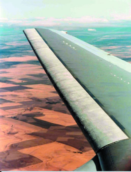
Dry snow is solid precipitation and rarely sticks. But wet snow is sticky, clumping easily, and presents a danger for pilots. If it accumulates on airfoils, evaporational cooling will allow the snow to “set.” This will, of course, interfere with the ability of the surfaces to produce lift. In 1981 in Washington DC, an Air Florida Boeing 737 crashed shortly after takeoff, and the cause was wet snow, not cleared on the ground, that bound to the wings once the aircraft was in motion.
Hail (GR)
Hail starts with wet ice crystals in a thunderstorm cloud that encounter supercooled water freezing onto the crystal. This produces a heavy ice particle called graupel. This is then carried in and out of updrafts, gathering many layers of icing.
Hailstones can grow to several inches before their terminal velocity exceeds the strength of the updrafts. The most hail in the U.S. is in the central U.S. where instability is highest, but there is a bias toward the High Plains where the surface is closer to the freezing level.
Obviously, physical damage, not icing, is your primary concern with hail. We tip our hats to France for the abbreviation for hail (GR), which comes from the French word for hail, grle.
Ice Pellets (PL)
Ice pellets are better known in the U.S. as “sleet.” Ice pellets always form due to rain droplets freezing while they fall through the air. These falling droplets may have originated from either a warm layer made up entirely of rain or can originate from melting snow. In all cases, the precipitation passes through an elevated warm layer, “warm” meaning above freezing.
This warm layer is generally 1000 feet deep or more, about 1000 to 3000 feet AGL. Shallower layers mean the snow doesn’t melt completely before reaching the ground. However, if the precipitation reaches a subfreezing layer, still in a liquid state, there is a layer of elevated freezing rain and severe icing. This icing layer is normally found at about 1000 to 3000 feet AGL, but icing can occur higher.
Below the icing layer, the precipitation has finally frozen solid and is being observed as ice pellets. There is little or no icing potential with ice pellets since the particles are frozen and unable to bind to the airframe. However mixed precipitation situations, as might occur with thinning cold layers along a warm front, can bring a risk of surface icing over time as the ice pellets transition to freezing rain.
Freezing Rain, Freezing Drizzle (FZRA/FZDZ)
There is often some confusion about what freezing precipitation is, but it’s very simple: freezing precipitation consists of normal droplets that freeze after they have impacted the surface. Freezing rain is exceptionally effective at glazing airframes with large amounts of icing, and should always be considered to produce severe clear icing conditions.
The freezing rain layer clings to the earth’s surface, and is very shallow and rarely extends higher than roughly 1000 feet AGL. Deeper cold layers would freeze the falling rain prematurely, causing a layer of freezing rain with severe icing at about 1000 to 2000 feet AGL, with ice pellets below. However, elevated icing layers and deeper freezing rain layers are still possible depending on the situation. A layer of warm air overlies this shallow surface layer, providing the liquid precipitation—otherwise it would just be snowing at the ground.
Avoid areas reporting FZRA. If flight weather products show FZRA developing all around you, always stay out of the lowest 1000 feet. Higher layers will usually have much safer flying conditions.
Fog, Mist (FG/BR)
Fog and mist commonly occur when there is ground moisture, clear skies, and slight wind (radiation fog). It may also form from extensive lift of a very humid air mass due to upslope flow, which is common in the Great Plains, or lift along a warm front. Advection fog is another type of fog that forms due to warm, humid air moving over a cold surface. Fog (FG) and mist (BR) are exactly the same, except fog is reserved for visibility less than 1 km (5/8 mile). BR comes from the French brume for “mist.”
Be especially wary of the phenomenon called “white-out.” This is associated with any mixture of fog, “elevated fog” (clouds), and snow on the ground. It can be a killer, as we’ve seen with Air New Zealand Flight 901, which crashed in Antarctica in 1979 due to disorientation and white-out. White-out, even if partial, can interfere with visual cues or distort them, giving a false sense of position and attitude. The conditions can set in gradually and slowly.
The solution is to switch to your instruments early: start using the attitude indicator, VSI, heading, altimeters, GPS, and other instruments early and often. Be proactive in making sure you don’t lose sight of reference points. If you are flying visually, don’t wait until only one visual reference is left before taking action. The FAA has training material about white-outs on their website.
Freezing Fog (FZFG)
Much like its cousin freezing rain and freezing drizzle, freezing fog is a layer of supercooled cloud droplets. The production process and droplet size are exactly the same as with common fog. The droplets are microscopic. However the air temperature is subfreezing, so the cloud droplets condense and freeze on any surface they come into contact with. The freezing fog produces light to moderate rime icing.
It is the very small droplet size and weak volume of liquid water that contributes to the weak icing potential. However if the air mass cools further or lift is increased, freezing fog can transition to a freezing drizzle condition with heavier icing potential.
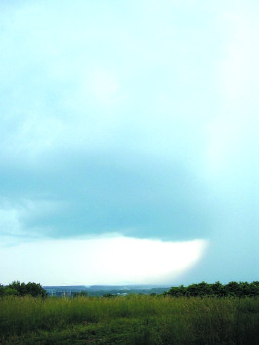
Showers (SH)
The “showers” or SH modifier is a prefix assigned to the major precipitation types, producing combinations like SHRA (rain showers) or SHSN (snow showers). This is always used when precipitation is being produced by cumuliform clouds. This in turn implies the existence of instability. Instability lends itself to mechanical turbulence, clear air turbulence, and low-level wind shear, so be prepared when the TAFs are carrying SH, even when the TAFs are not explicitly forecasting them.
The existence of cumuliform types also means deeper precipitation layers. With wintry lake-effect snows, as well as snow showers produced by movement over warm terrain, the clouds are often shallow, on the order of a few thousand feet. However in warmer air masses, clouds may be tens of thousands of feet.
Thunderstorm (TS)
The thunderstorm designator has traditionally been assigned when the weather observer hears thunder. The arrival of automated weather observing systems, however, has changed the meaning of this designator. It’s now used when lightning detectors indicate lightning activity less than five miles away. If it is greater than five miles away, it will be reported as in the vicinity (VC).
Thunderstorms always mean rain or snow, showers (SH), and cumuliform cloud types. You can also expect substantial cloud depths. In warm air mass situations, the critical icing layers for producing thunderstorms normally occurs at an altitude of about 15 to 20,000 feet MSL. During the cool season, thunderstorm icing layers average about 10 to 15,000 feet MSL.
Drifting Snow, Blowing Snow (DS/BS)
Drifting and blowing snow are simply the phenomena of snow on the ground being lifted by the wind. The process of lifting the snow is much more likely in fresh-fallen snow and especially dry snow, since wet snow tends to clump together. Dry snow is usually found in very cold air masses and dry climates, so blowing and drifting snow are mostly seen in the Northern Plains and Northern Rockies. The difference between the two is that drifting snow remains below eye level (about six feet) while blowing snow is raised to higher heights by stronger winds or drier snow powder.
The aircraft itself may produce its own blowing snow phenomenon. For those not accustomed to winter weather flying, you will see it while landing. As the aircraft flares, the snow on the runway is kicked up, and visibility drops sharply. So be prepared for losing visual cues during those last few inches when floating over the runway in dry climates.
Ice Crystals (IC)
When the fog air mass is so cold and humid that there is widespread condensation of microscopic ice crystals we get ice crystals (ice fog). Temperatures must be about -30 degrees C or less, otherwise we simply see freezing fog (FZFG). Although the same factors apply—cooling or lift of a humid layer—it is often the addition of nuclei that generates ice fog in bulk. Good sources are automobiles, aircraft, chimneys, and power plants. Light rime ice is normally all that’s observed by pilots.
As sun angles are low where ice fog occurs, radiational cooling of the fog tops is a significant factor, allowing the cold layer to deepen and cool over days. This intensifies the inversion with even more widespread fog and more trapping of pollutants, resulting in a chain reaction. Valleys in rugged terrain are especially good at trapping this air. Visibility can be severely impeded, dropping to fractions of miles, often near zero, for many days. The cycle is only broken up by the approach of large scale weather systems that pick up the winds and disperse the inversion.
What More Is There?
This should have given you a better insight into all the different forms of precipitation you’ll see while flying. In combination with this article I recommend a few back issues of WX Smarts to review: “Fronts” (March 2017), “Icing Weather Basics” (December 2014), and “Winter Accidents” (December 2016). All of these are a good preparation for flying this winter. Stay safe!
Meteorologist Tim Vasquez used to brief B-1B crews in the morning. Now he sleeps in and writes books and software. See his website at www.weathergraphics.com.


