
The Ol’ Switcheroo, V2
In the October issue, “The Ol’ Switcheroo” letter and your response discuss flying an approach to one well served airport, then “hopping over” to another airport lacking sufficient approaches. Portland, Oregon is mentioned as one place that can work well.
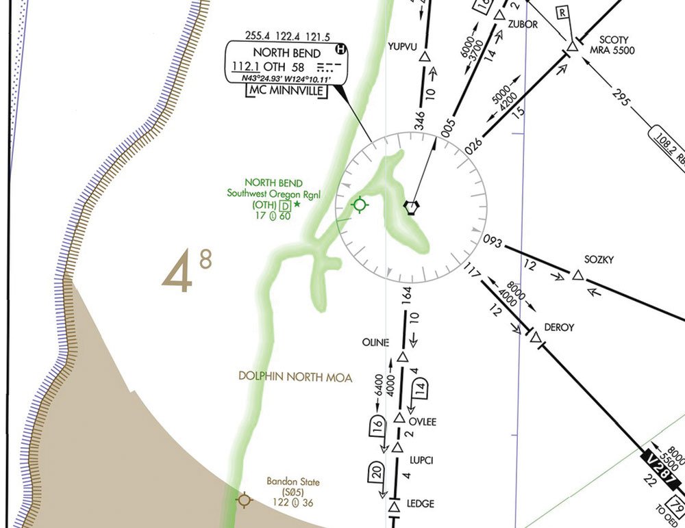
I want to caution you that the airspace around PDX all ends up requiring three miles of visibility and 500/1000/2000 cloud clearance. Pilots here have been busted for doing exactly what you discuss because they did not have legal VMC in which they could cancel the approach. The same thing is true when using the referenced ILS or RNAV 4 approach at North Bend to get into Bandon State. Your destination may be Class G, as Brandon State is, but the airport whose approach you’re using is Class C or Class E airspace, depending on where you are on the approach.
Consider using a contact approach or even a visual to the destination airport.
Steve Wagner
Stillwater, Minnesota
We did mention, but it bears emphasizing, that this “hop over” to another airport requires VMC where you are, not where you’re going. The switcheroo can be useful, but the weather requirements are tight and immutable.
Your suggestion to use a contact approach is interesting. Note, however, that one requirement for a contact approach is that the airport to which you’re going must have at least one published instrument approach. Brandon State doesn’t.
However, if you’re coming from the south, you might consider asking for that contact approach into North Bend, getting down low into VMC appropriate for the airspace, and cancelling long before you get to North Bend. That’s all tricky, but a useful tool to have in your arsenal.
Don’t Dis My NDB Approach
Your editorial in January talked about removing unneeded approaches, and specifically picked on NDB approaches. My home airport has but one strip with a GPS approach to one end and an NDB approach to the other. When the wind is right (well, wrong), the NDB approach becomes the only option. Eliminating that would further limit the utility of this small airport.
Gordon Tones
Camrose, Alberta, Canada
Fair ‘nuff, Gordon. However, I was really referring to redundant approaches. Consider this note from our “inside source” at the FAA: “We’re targeting redundant, under-used approaches. A good example is Sioux City, Iowa (SUX). They have two ILS/LOC approaches, four RNAV’s, two High VOR/DME or TACANs, two VOR/DME or TACANs, and four NDB approaches, all for two strips/four runways.”
You went on to ask what constitutes “redundant.” To me that means any approach that isn’t likely to be used because of other available approaches. Take any airport at the heart of a Class B, for example. Chances are it has an ILS to each runway, yet it probably also has RNAV and VOR approaches, none of which are ever likely to be used.
Tablet Wars
Your article on the iPad mini (January)would have been better not mentioning the Android or other tablets at all rather than providing incomplete info about them. The Nexus, for example, is a far better value and performer than the Apple. Also, if you happen to be a PC user, there is a price to pay in user inconvenience for using iPad technology.
Vince Massimini
Kentmorr Airpark, Maryland, USA
Vince, you make valid points, but missed the point of the article. That article was intended to introduce a new product. It’s often easiest to do that in terms of existing products, which we did. We had no intent to do a full market comparison. That’s planned for an upcoming issue.
True North Nav
I remember using Grid Navigation in the B-52. Thanks for the review in January.
I’m still not sure how an AHRS system would be used in the high latitudes. For example, some Garmin 1000 models are restricted from operation between 65 and 70 degrees in some latitudes and above 70 in others. I know that the GPS could be switched to true track. Would that satisfy the requirement?
George Shanks
Waxahachie, Texas, USA
Lee Smith, the author, responds: “Just like with a GPS, some AHRS units can be switched into true heading reference. The Avidyne cannot be. The G1000 can, but even if true heading reference is selected, the displayed heading will still be magnetic with courses shown in true.
“It’d be easiest to just follow the magenta line. But what if the magenta line disappears? This may be where the aircraft latitude limitations come from. While it’s possible to compute and correct grid courses by hand, it’s certainly not ideal.”
What Ice Do You Know?
In “Knowing Known Ice” in January, Lee Smith says “For aircraft lacking a FIKI certification, that means steering clear of all forecast ice.” This would ground most of the fleet in the Great Lakes region where I fly most of the time. Often forecast icing is localized or nonexistent and can be overflown or otherwise managed. The updated opinion by the FAA’s counsel was specifically to avoid such a position; known ice needs more than just a forecast to be defined.
David Dodson
South Bend, Indiana, USA
Lee Smith replies: “That updated opinion makes a distinction between “known ice,” which does require evidence of actual existence, and “known icing conditions,” determined by the pilot based on available information (including forecasts). This is a significant improvement from the previous restrictive definition of below freezing temperatures with visible moisture and allows the pilot to determine if a flight be practically conducted outside of actual ice.
“However, ignoring weather forecasts based on local knowledge may not satisfy the FAA’s opinion. If there’s a big ‘ol AIRMET over the area, but PIREPs or CIP don’t indicate icing at your altitude, then you’ve done your homework and can make the flight. However, if all you can get your hands on tells you to expect light icing en-route, it doesn’t seem prudent to launch and assume you can avoid it.”
Send your comments, praise, criticisms, suggestions and complaints to [email protected].


