
Going Below Minimums
Please thank Ken Maples for writing this much needed article that appeared in your May 2022 issue. Many of us pre-brief approaches from home, including highlighting the chart and adding annotations. From now on mine will include a visibility checkpoint. Interestingly, for my home field, S50, Auburn (Washington), the speed Category A minimum visibility is listed as 1¼ SM, which measured out from the threshold leaves about 0.8 NM to go before reaching the MAP.
With this in mind, I’m sure there have been a lot of illegally completed approaches. This is not proactively policed in any way. It’s not like a school zone with a motorcycle cop hiding behind a tree. However, when a field, like ours, has no visibility reporting on site, your good faith estimation of visibility needs benchmarks for accuracy if you’re going to rely on it for safety.
If after breaking out into visual conditions you have to make major corrections to line up for the runway and it’s the last third of the runway where you’re landing, perhaps you really didn’t have the required flight visibility to begin with.
Dan Anderson
Des Moines, Washington
Not only must you have the required flight visibility—best determined from the approach lighting system, if adequate—but according to §91.175 you must land using normal maneuvers. That’s an oft-overlooked and oft-violated requirement, illustrated by your comments.
It’s common for non-precision approaches to have the MAP well beyond the point of visibility requirements. This suggests to many pilots that you can land as long as you see the runway before the MAP, when in fact you’re long past having legal, required visibility. Plus, of course, landing from those MAPs requires far from the requisite “normal” maneuvers.
Years ago, long past the statute of limitations so I’m free to talk about it, my home ’drome had a runway perpendicular to the coast. Coastal fog was a constant threat at the airport. I was once on the localizer approach, landing away from the coast. I was deep in the coastal marine-layer fog and simply not breaking out. It was one of those approaches, like yours, where the MAP is too close to the runway for a reasonable landing from there.
On this particular day, I broke out just about at the MAP—not out the bottom of the layer, but out of its leading edge. It was suddenly clear ahead with miles of visibility. “Runway in sight!” Full flaps, gear down, power to idle, flat prop, slip—I descended at some excessive rate. I was determined to land. Land I did and with heavy braking I was even able to make the first turnoff—at the far end of the 4500-foot runway.
A couple of my buddies were hanging out at the airport and chided me when I came in. I was proud of having made it, but one of them said something about “normal maneuvers.” I then recalled, “Oh, yeah. That. Okay, maybe not the best. Hand me a beer, would ya?” And, no, there wasn’t a Fed around to ask me about it. Fortunately.
I’ll never do that again. That approach haunts me to this day. That was clearly a recipe for immortalization in our Stupid Pilot Tricks.
GPS on VOR Approach?
Let’s say you are flying the VOR-A approach into KOKB, Oceanside, California. You have a Garmin GTN 650, which you set up for “monitoring only,” and you fly the approach off of a separate #2 nav and separate VOR display. You do not have DME.
The FAA chart only shows the MAP at 3.4 DME from OCN VOR, or timing after crossing the VOR. Could you also legally use the MA096 that the 650 shows? I don’t think so—it is only for “monitoring,”—but I am not certain. There is also a practical answer if the moving map on the Garmin and iPad-ForeFlight shows you are close to the airport at MDA, but what is the legal answer?
Brian Wamsley
Coronado, California
Not sure what you mean exactly by “monitoring only.” Let’s assume this just an exercise in using the VOR receiver separately from the GTN. Fine … good practice.
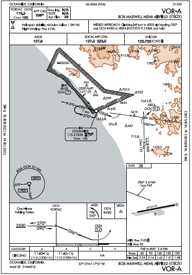
In short, your answer lies in Advisory Circular 90-108, specifically paragraph 7.a. You are permitted to use GPS to identify your position relative to a VOR, in this case OCN D3.4, for the MAP. The fact that when you load the approach into your navigator it also names OCD D3.4 doesn’t change the fact that you’re using GPS in lieu of DME. However, having loaded the approach into the GPS suggests you’re using the GPS for more than monitoring. If you really want to make it as challenging as possible, don’t load the approach but instead merely use OCN as your active waypoint and monitor your distance, just as if you were using an actual DME.
While navigating via moving map is a rather common practice and isn’t to our knowledge explicitly prohibited, it’s considered poor practice—the map is not for navigation per se. Instead, it is for situational awareness. The actual instruments (RMI, VOR/HSI, etc.) are for precision navigation.


