
Some places get the best names. Take Yakima, WA, for instance: Gromo, Naches, Zilla—that last one is worthy of a Japanese movie monster. Maybe even “Gromo versus ‘Zilla” as Tokyo burns. My inner eight-year-old rejoices, and wants a plate of nachos.
That inner third grader also giggles at Yakima’s Wenas 7 departure, both for the vaguely salacious name and the angst it caused many a hopeful cargo pilot. When I instructed in Seattle, we’d prep pilots going for charter and cargo interviews. A common sim task was the Wenas departure with killer winds that got complicated by an engine failure and a back-course, one-engine return … hmm, sounds like a Sim Challenge.
Warm-Up with Pasco
But, don’t start at Yakima (KYKM). Put the airplane on the ramp at Tri-Cities airport in Pasco, WA (KPSC). Fly something fast if you can. A twin with the potential of an engine failure could be just what you need.
Depart Tri-Cities for Yakima from Runway 21R. You filed PSC V298 YKM and got a clearance with, “Cleared to the Yakima airport via Tri-Cities 7 then as filed. Climb and maintain 6000.” Use real-world weather so the winds are variable for this day. Or, if you must, dial up 800-foot ceilings and a wind out of the southwest. Set the radios, brief your route. Then fire up and taxi out. Assume Tower’s last words to you were, “…on departure, fly runway heading. Runway 21R, cleared for takeoff.”
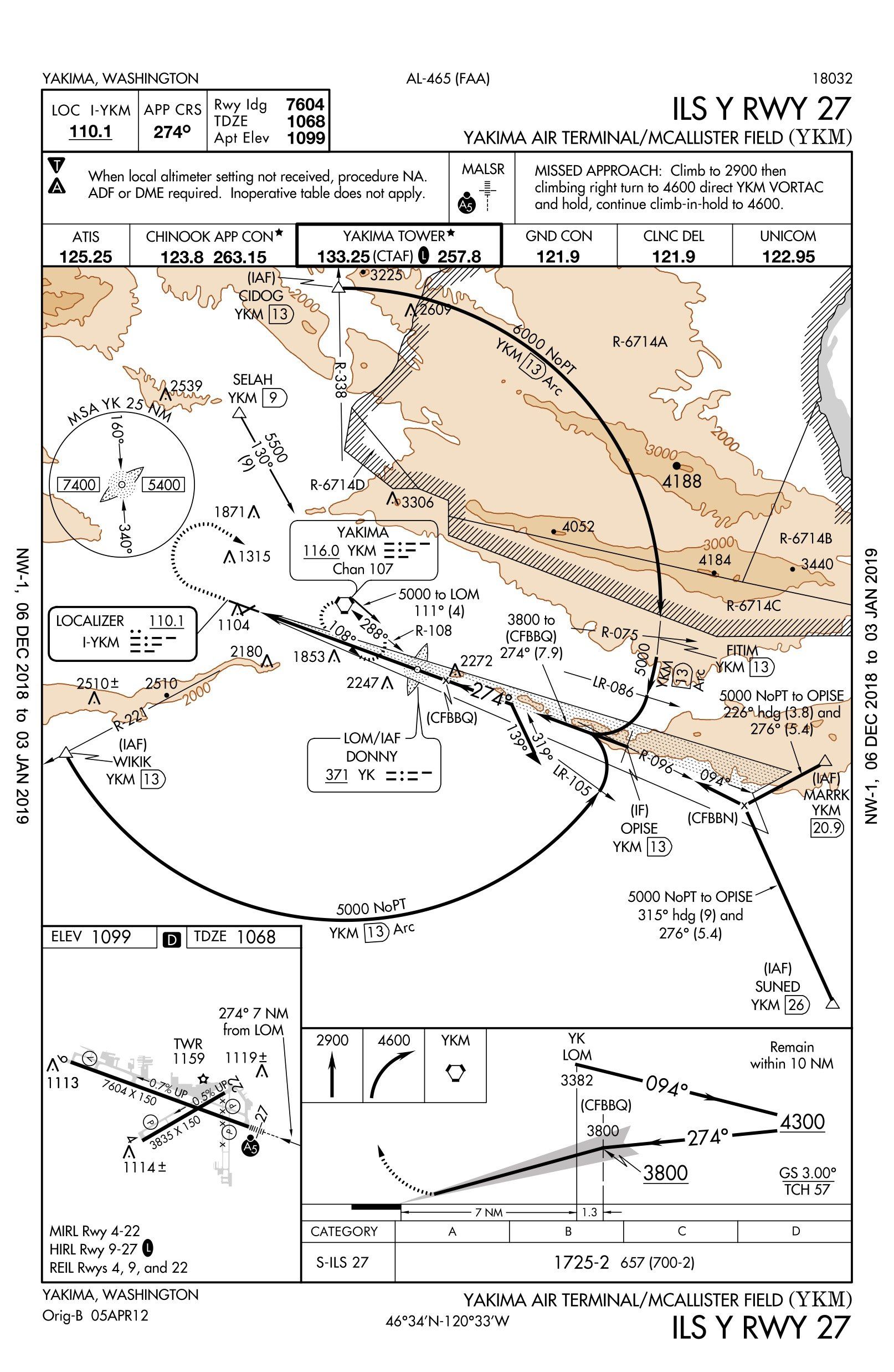
Through 2500 feet, Tri-Cities Tower passes you off to Chinook Approach. You check in and get, “Radar contact. Fly heading 290 to join V298 then resume own navigation.” Get on V298 and whip out the ILS Y or Z for Runway 27 at KYKM. Fly the approach from SUNED off V298. Take it to minimums before you look up and land on Runway 27. Taxi to the McAllister Museum of Aviation and park for a moment.
Climb Aboard the Arc
The departure will be off Runway 9 with a clearance to Auburn, WA, of WENAS 7.PERTT V298 SEA. Don’t worry about the identifier for Auburn; you’ll never get there. How you’ll handle the rest of this sim challenge depends on whether your sim has GPS and how much challenge you want. If you have profile view and/or the hazard advisor on ForeFlight, turn it on just for fun.
Using your equipment as befits your needs, depart Runway 9 and fly the WENAS 7 to SELAH. Start the PERTT transition and fail a nav. Each sim setup will necessitate its own tweaking here, but leave yourself with a single VHF radio and a DME. You might need to turn your GPS map to some other screen and set it for direct YKM in lieu of DME. Make sure the remaining nav can play to a CDI with a glideslope as well.
The PERTT transition can put you onto a DME arc from CIDOG back to the ILS Rwy 27. (The restricted areas are cold.) Land and roll out to the end of Runway 27 so you can turn around, ready to depart Runway 9 again.
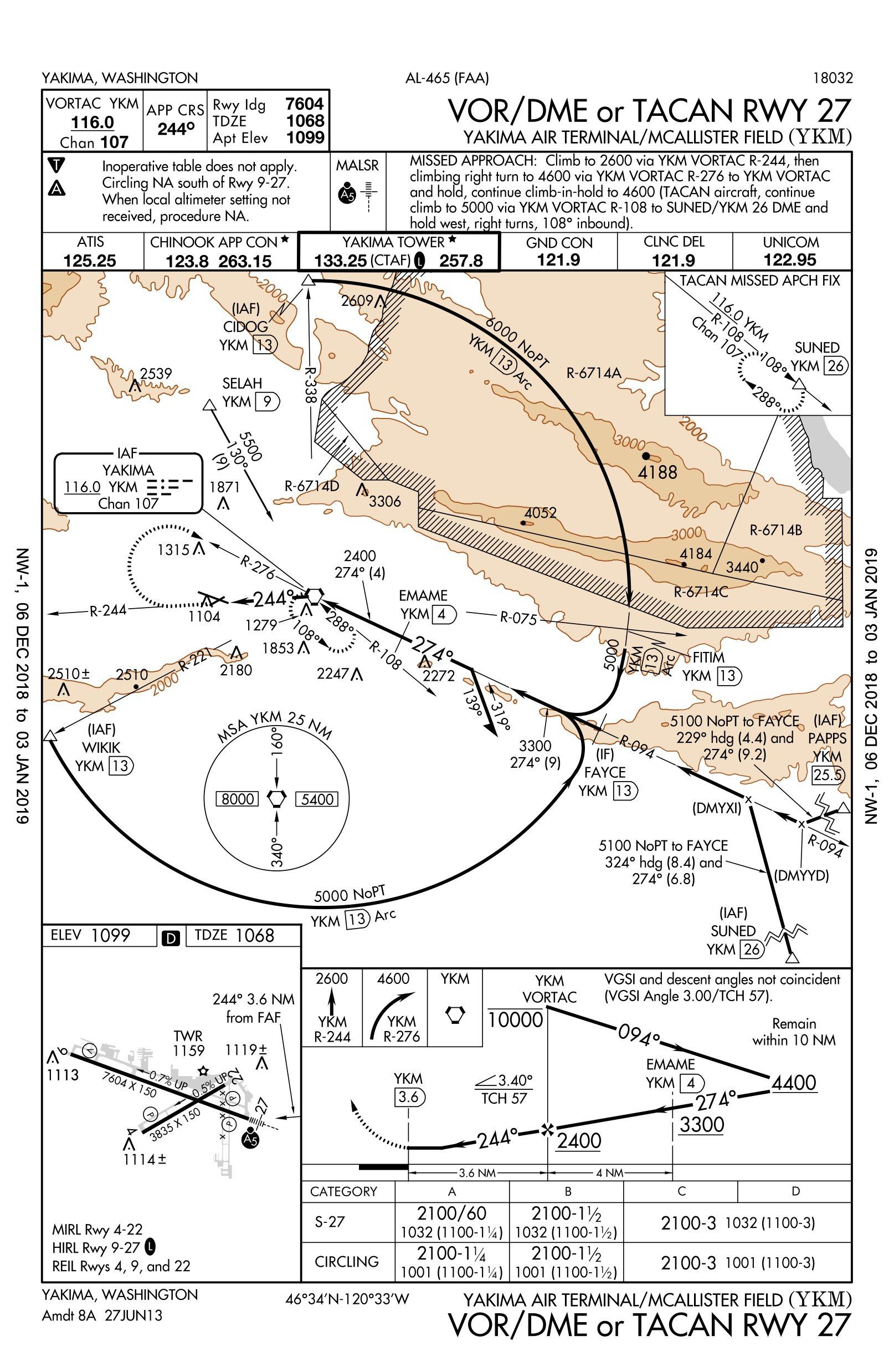
Fall behind on that at all? If not, fly something faster. If you did fall behind, here’s a chance to redeem yourself. Set up for departure and do it again: WENAS 7 from Runway 9 to the arc, but this time fail the number one nav before reaching SELAH. (Extra challenge: Use just the one nav radio for course guidance and use your tablet for DME position. Hey, it could happen that way in the real world if you lost your only GPS navigator.) Using only the one nav, fly the VOR DME Rwy 27 approach from SELAH. Land and roll out to turn around, ready to depart on Runway 9 again.
If you want to amp up this challenge a bit, depart and join the WENAS 7 again (Gettin’ good at it by now?) but this time fly the TITON transition cleared to 7000 and hold as published at TITON. Take a turn or two to get the timing and then fail down to one nav and one DME like before.
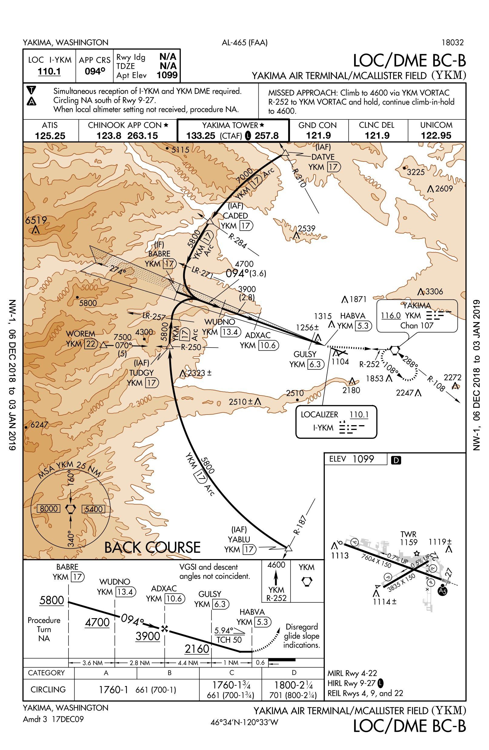
Fly the LOC/DME BC-B and continue past TITON on R-284 to CADED and join the arc in the other direction for the backcourse approach. If you’re flying a twin, do it with the left engine caged. Once you cross GULSY, drop to MDA as quick as you can and look for a runway. Bonus points if you can land straight-in Runway 9. Otherwise, tell the tower you’re circling for 27.
Taxi to the ramp and put it in the chocks. The airport is your Hotel California: You can depart, but you can never leave.
Questioning Yourself
1. What margin over the required climb rate did you have departing Pasco? Would a heading on departure be better than the procedure?
2. How would you check in with Chinook Departure? How high can you climb before Departure acknowledges your presence?
3. How far is PSC from SUNED?
4. What was your heading when you intercepted the localizer for the first approach to KYKM? What navigation source were you using?
5. When can you descend to 3800 on the approach from SUNED?
6. At what altitude did you turn left to intercept R-255 on the WENAS 7? Did you meet the climb gradient?
7. What altitude did you fly from SELAH to CIDOG? At what altitude did you intercept the localizer?
8. Suppose you lost your DME (or GPS in lieu) and only had one nav radio at SELAH. Could you fly the ILS approach? Localizer only?
9. For your third approach, you crossed SELAH and turned southeast to the VOR for an outbound and a procedure turn. How far out did you go before turning around?
10. What was your final approach course on that VOR/DME Runway 27? Where was the runway when you broke out?
BC Bonus: You know the backcourse is aligned with the runway, but it’s circling mins only. You can see from the other charts Runway 9 has lights and a VASI, so that’s not preventing straight-in minimums. What can you expect from that backcourse approach if you fly it?
Possible Answers
1. It’s easy to overlook departure climb gradients, but it’s worth checking. The Tri-Cities 7 requires a climb of 310 feet per NM to 3500 feet (about 2400 feet AGL)—over 50 percent higher than standard. If you maintain 400 fpm normally, you’ll need 620 fpm here. With a heading to fly, you’d have to check the diverse departure climb gradients, which are also non-standard for Tri-Cities (filed by the city name “Pasco”), but lower than the published procedure.
2. “Chinook Departure, Bugsmasher Two Three Foxtrot [current altitude],” is all that’s needed, although saying your cleared altitude helps keep everyone on the same page. You’re not “climbing via” on this departure. You were cleared to 6000, so that’s how high you can go without ATC communication (until an MEA forces you higher), but after 3500 feet with no com, you should be turning back to the PSC VOR before climbing on course at or above the MEA.
3. It’s confusing at first. There’s a 22 for BENTY to SUNED, but then there’s a 61, that looks like the whole leg. But that can’t be right. There’s also a 13, from PSC to BENTY, which when added to the 22 gives you 35 from PSC to SUNED. The 61 is in a box, so it’s between navaids—on V298 from PSC to YKM.
4. The correct answer is 276 via the YKM VOR. This is an odd NoPT transition that has a dead reckoning leg (heading 315 from SUNED) to intercept R-096 from YKM, which in turn intercepts the localizer. Without GPS, there’s no navigation source from SUNED to the VOR radial. With GPS, it uses those computer navigation fixes in parenthesis. They’re in your GPS, but not on ATC screens.
5. The procedure is to maintain 5000 until OPISE, about 9.3 NM from the LOM. If you flew that 315 heading from SUNED to the localizer, intercepted and then descended, you’re probably outside 10 NM—and too close to the hills.
6. Load this in a GPS, the first “waypoint” is 1499 feet because airport elevation is 1099 feet and departures begin at 400 feet AGL. That’s when you should start your turn. Runway 9 requires just over twice the normal climb gradient all the way to 6000 feet. If you budget your departure climbs on a 120-knot groundspeed (to account for changing winds) that’s a bit more than 800 fpm to 6000 feet. This could be a real challenge in a non-turbo, piston single.
7. The WENAS 7 MEA for this segment is 6500, so you’d be requesting a climb by then. However, CIDOG is 4 NM from SELAH, and the obstacle protection is 4NM wide on the arc, so you’d be OK at 6000. Also V298 has a GPS MEA of 5400. So you’re good on obstacles at 6000. You could have been down to 5000 for the last of the arc (past R-075), however.
8. You could fly the ILS. Fly from SELAH to YKM, and then 108 degrees to the localizer. With some fancy nav flipping you could do this with one nav only. Then estimate your distance outbound by time before reversing course. There’s no localizer-only version of this approach.
9. You’ve got 3100 feet to lose between the VOR outbound at 5500 and inbound at or above 2400. There’s no requirement to pass EMAME before your course reversal. Note that past EMAME, you can’t descend below 3300 inbound until you get within 4 NM of YKM. And the whole PT must remain within 10 NM of YKM, not EMAME.
10. If you missed that the final approach course is actually 244, you probably missed the whole approach because the runway was far to your left. A 30-degree turn at the FAF is uncommon these days, so it could catch you sleeping. That also puts this approach right at the limits for straight-in minimums. Good lights and a reasonable descent angle help.
Bonus: It’s going to be a steep descent for a straight in. Look at the chart and you’ll see it’s almost six degrees downhill from the last fix to the touchdown zone.
“Normal maneuvers” anyone?
Jeff Van West is convinced whomever said, “size doesn’t matter” never had an emergency on a nine-mile DME arc.


Jeff….keep up the good work! We can tell who are strangers in these parts by the way they pronounce Wenas like wenis (rhymes with penis) instead of weNASS (heavy on the ass). But i digress. I keep my P210 at KYKM and agree that the Loc/Dme BC is a bit of a problem child and most of us have difficulty, with the usual tailwind, getting down to minimums prior to the runway. But, no hay problema, as we say in the valley these days; just displace to the north for a right downwind for runway 27. It is, after all, circling approach minimums and the prevailing winds are usually out of the west, particularly when Imc conditions are here. Also, on the VOR approaches, if you make your last fix the top of the Costco building it nicely lines you up with rnwy 27.