
Rocky Mountain Metro (KBJC, “Metro”) is an active general aviation airport located about 21 NM west of Denver International Airport (KDEN) and just outside of the westernmost north-south border of Denver Class B airspace. While the elevation of Metro is 5673 feet MSL, about 10 miles to the west, the Rocky Mountains reach altitudes of 10,000 feet MSL and higher. The airspace around Metro has several airports, some with gliding and parachuting activities. Periodically the air traffic around Metro is heavy not only because of events but because aircraft typically fly the North-South corridor between the Rockies on the west and the Denver Class B on the east side.
But … They’re the Same
Metro has five approaches: an ILS/LOC, three GPS, and a VOR/DME. We’ll review two approaches to the same runway (30R): the ILS or LOC RWY 30R and RNAV (GPS) RWY 30R. Look closely at these two approaches and you’ll see … they both follow essentially the same path over the ground. The ground track from two Initial Approach Fixes (IAF) ROKXX [A] and NYSPR [B] to the final approach course is the same. Additionally, both approaches can be flown to decision altitudes (DA). (While GPS approaches are currently all considered non-precision, this is expected to change soon.)
The DA for both the GPS [C] and ILS approach is 5799 feet MSL, but there is an asterisk on the latter. The Notes Box of the ILS approach [E] states: “Missed approach requires a minimum climb of 240 feet per NM to 9700.” This requirement is not mentioned in the GPS approach. Since our aircraft don’t have a Climb Gradient Indicator we need a little math to convert climb gradient to vertical speed at our ground speed. With a ground speed of 120 knots (two NM per minute), the required climb rate needs to be 480 feet per minute (FPM); at 90 KTS, 360 FPM meets the 240-feet-per-NM requirement.
If an aircraft can’t meet that requirement, then the ILS DA min that applies [F] is 6124 feet MSL, a difference of 325 feet from the unconstrained DA of 5799 feet MSL. The required visibility also increases from ½ SM to 1⅜ SM. If we look at these using their decision heights (DH), there is a 263 percent difference in HAT: 200 feet vs. 525 feet. However, if flying the GPS approach in the same aircraft that does not meet the 240 feet per NM climb gradient, the LPV DA [C] stays at 5799 feet MSL with a ½ SM visibility.
There is something else that appears a bit odd. A circle-to-land (CTL) maneuver at the end of an instrument approach must be accomplished visually. CTL could start anytime that the landing runway is clearly visible and the aircraft can safely be maneuvered. The latest point where CTL can start is at the non-precision missed approach point, (in these, and in most cases) the runway threshold.
For the GPS approach, the MDA for the CTL [G] is 6180 feet MSL (Cat A aircraft) or 6240 feet MSL (Cat B aircraft). On the ILS, for both Cat A and B aircraft, the MDA is 6340 feet MSL [H]. We’ll discuss what appear to be anomalies between the two approaches regarding straight-in and CTL minimums in a bit.
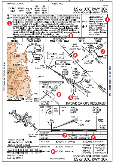
On the Missed
In general, even when flying ILS missed approach procedures using GPS, HDG legs are still subject to the effect of the winds. GPS will not help. However, if a VOR radial is involved on a leg, GPS, if available, will generally be more precise. Now, note that the path to the missed approach holding fix, HYGEN, is somewhat different between the two approaches. The ILS tracks the FQF R-306 (FALCON VORTAC) [I] to the missed holding fix, while the GPS approach goes direct after the initial—slightly higher—climb.
In actual IMC, it’s uncommon for the published missed to be flown. Once a missed is announced by the pilot, the controller will almost immediately respond, “State your intentions.” Usually our intentions are not to fly the published missed, but to go back around for another try, or head to an alternate. With that in mind, we still brief the published missed and often fly an initial portion, especially if an immediate turn is charted. But we should have an actual “intention” in mind to articulate as we configure the aircraft to climb.
The straight-line distance from Metro to the holding fix (HYGEN) [J] is about 29 NM. The Metro controllers stated that even for practice we would not be able to fly the published missed given the typical VFR traffic in the area. Maybe we could at 3:00 AM local but I didn’t bother to ask.
Alternate Missed Approach Fix
The ILS approach has a charted “Alternate Missed Approach Fix” (AMAF) [K] which also happens to be HYGEN; such fixes appear only on approaches that use ground-based navigational aids. In other words, AMAFs will not show up in GPS approaches. The main reason for an AMAF is if the primary ground-based navaid experiences an outage, in the case of Metro an outage of FQF. Additionally, there is not much of a difference between the two missed approach holding patterns as both are based on HYGEN with a difference that the inbound holding courses at HYGEN change from the 306-degree radial of FQF to the 302-degree radial of DEN.
There are no published instructions on how to get to HYGEN using DEN. When AMAF is charted, the missed approach instructions would be in a NOTAM, which of course, you’ve briefed as part of the flight planning process. Typically, even when flying an ILS, we tend to load the approach in a GPS navigator, and the miss is then flown using GPS. (The HDG legs should be flown with the HDG bug when using an autopilot.) However, the alternate missed approach procedure would not be in the navigator’s database. Therefore, we can’t activate the missed approach but need to remain in “suspend” mode and fly the missed as published in the NOTAM. This could imply hand flying, or using HDG on the autopilot, and/or tracking a radial in NAV mode (on autopilot).
In the case of Metro, flying to the AMAF will not be very different from the published missed, but we need to intercept the DEN R-302 vs. the FQF R-306. Last, the hold would not be in the GPS database, so we would need to create the hold in the navigator if using GPS. As noted, this might be academic at Metro since a miss in actual might not result in flying to HYGEN, unless we lose communications.
Standard Procedure Notes Box
The notes boxes [L] are quite extensive, and the best way is to review as an element of flight planning and highlight only the relevant segments. In both approaches, only part of the notes are applicable given specific conditions.
Paradoxical Minimums?
As mentioned, there seem to be (at first sight) discrepancies between the minimums for the ILS and GPS approaches. The circling MDA for the GPS approach for CAT A aircraft is 6180 feet MSL [G] and for CAT B 6240 feet MSL. Compare that to the circling MDA of 6340 feet MSL [H] for the ILS approach (CAT A and B aircraft). The reason is simple. The circling minimums cannot be lower than any other minimums within an aircraft category, but could be equal. In the case of the GPS approach, the MDA for the LNAV is 5940 feet MSL for both CAT A and B aircraft, so 6180 and 6240 meet that criterion. In the case of the ILS, there is a side-step to RWY 30L with an MDA of 6340 feet MSL, which is the same as the circling minimums for CAT A and B aircraft and meets the criterion.
But, the biggest discrepancy is that the ILS missed approach requires aircraft to meet a higher climb gradient of 240 feet/NM compared to the standard 200 feet/NM. If the aircraft cannot meet that requirement, the DH increases from 200 feet AGL to 525 feet AGL, which is substantial. But the GPS approach has a DH of 200 feet AGL and with no climb gradient constraints other than the standard 200 feet/NM.
The paradoxical discrepancy is that the respective missed approaches influence the straight-in minimums. For the GPS missed approach [M] , the first leg is a heading that requires a climb of 501 feet from the DA of 5799 feet MSL to 6300 feet MSL. That climb could happen rather quickly, perhaps a minute or less, then direct to the holding fix at HYGEN and continue climbing to 10,300 feet MSL. Since the leg to HYGEN is GPS-based, the resulting ground track is more predictable—less sensitive to wind effects.
For the ILS, the miss [I] is initially similar. Straight ahead climb to 6380 feet MSL (rather than the 6300 feet MSL), followed by a climbing right turn to a heading leg of 360 until intercepting the FALCON VORTAC (FQF) R-306, then to HYGEN on that 306-degree radial. Like any heading leg, the ground track of the second heading leg is not well defined because it is strongly subject to winds. With strong easterly winds, the ground track could place the aircraft near the mountains to the West. If the aircraft cannot meet the 240 feet/NM climb gradient, an additional DA increase of 325 feet is needed for safety.
Additionally, the charts could be visually misleading when superimposed since the respective dotted lines representing the missed approach tracks seem to be similar for both approaches but are typically not the same, especially if winds strongly affect the ILS missed ground track.
Part of all flight planning involves studying potential approaches, especially when flying to a new airport. However, even at familiar airports, it does pay to periodically review the approach charts. You might pick up previously missed insights about well-known approaches.
Luca F Bencini-Tibo wonders where he can buy a Climb Gradient Indicator. Instead of the published missed, he prefers to fly the approach again or go to an alternate (filed or other alternate).


Luca wants to know where he can purchase a Climb Gradient Indicator – if he uses Foreflight, he already has one. A CGI is one of the choices for the Instrument Panel at the bottom of the Map Page.