
In our previous episode, we shared seventeen of the most common pilot avionics errors identified in FAA and NASA studies. If 80 percent of consequences come from 20 percent of the causes, knowing even this little goes a long way.
Now, using the classic learn-from-our-mistakes reasoning, the FAA then swaps its perspective from reactive (noticing and fixing errors) to proactive (preventing errors). The advanced cockpit, rich with information resources, enables pilots to catch and correct many mistakes before consequences occur. In the spirit of using all resources at hand, let’s devote our fourth and final article in this series to exploring the opportunities we have to nip these errors in the bud.
Cross Check Calculations
Planning a trip from Sioux City, IA (KSUX) to Longmont, CO (KLMO), you attempt direct routing only to discover the O’Neill MOA squarely in the way. The online flight planner offers GEGGE V219 OBH V172 LBF V80 AKO V8 DVV V575 WOLTS. You plug these into your GPS.
Something’s off. The online flight plan says the route distance is 442 NM. But the cumulative distance in the GPS flight plan shows only 429 NM. (Note that a mile or two difference between flight planners is not uncommon, but is still worth double checking.)
Back on the map page, the route’s continuity looks fine at first, but does it circumvent the O’Neill MOA? And where did the 13 miles go? You drill down from the 75-NM scale to 15 and start scrolling through the route. What’s pulling the route out of shape? You note a missing airway number. It looks like you forgot to insert the OBH VOR and its airway, so you enter it, and now the numbers match. Had you not caught the mileage discrepancy, you could have violated your clearance and flown into the MOA. Good save; feel good.
Notice that the automation masked your error because a GPS automatically connects dots, with or without an airway. You saved the day because you cross-checked flight plans. A little paranoia is a good thing.
GIGO, the computer programmer’s mantra for “garbage in = garbage out,” applies equally to avionics. You don’t necessarily get what you want; you only get what you program. No need to check every fix along an airway but check every airway transition and especially the departure and arrival segments of the route.
The FAA recommends we check four elements of every flight plan. Here they are.

Waypoints
Compare the sequence of waypoints on the GPS flight plan page to those in your proposed clearance. Are any missing? Did you or the GPS mistakenly insert unwanted waypoints? Did you misspell any?
A GPS flight plan connects waypoints in sequential order as entered, whether they make sense or not. A misspelled waypoint in the middle of a flight plan might be 3000 miles away, and then 3000 miles back to the next correct one.
GPS flight plan tools let the machine guide your way. However, it’s faster and safer to know what you want up front and program the route accordingly rather than guess your way through.
Some navigators allow the pilot to upload a flight plan from an app. The conscientious GIGO-aware pilot checks both the app and the uploaded flight plan for correctness.
Check the Distances
In the earlier example, the flight plan page was set to cumulative distance. The default option in many navigators sets the data field to distance between waypoints. This setting can be handy to track down one or more errors in a lengthy flight plan. Compare these distances to the nav log generated by hand, online, or in an app. Unusually long or short legs are worth investigating.
A common mistake is to misspell the name of a waypoint. If you enter SPIDR instead of SPYDR, you could get caught in a web of your own making.
Deviation and Desired Tracks
Pilots sometimes question why there is a small but nagging difference between a printed magnetic course and what the GPS says. Is something wrong?
No, not unless it differs by more than a few degrees. Your GPS converts true course into magnetic course using current variation surveys that might be different from the survey last used on a VOR. GPS navigators might calculate variation differently, and different IFR charts use a variety of sources. The AIM says that a properly operating IFR GPS with a current database should fly the correct ground track for any loaded instrument procedure. In any discrepancy, the chart rules, as always.
A GPS plots a great-circle route, the shortest distance between two points on the surface of a sphere. You can see its effect if the path is long enough. The desired track gradually changes as the route is flown.
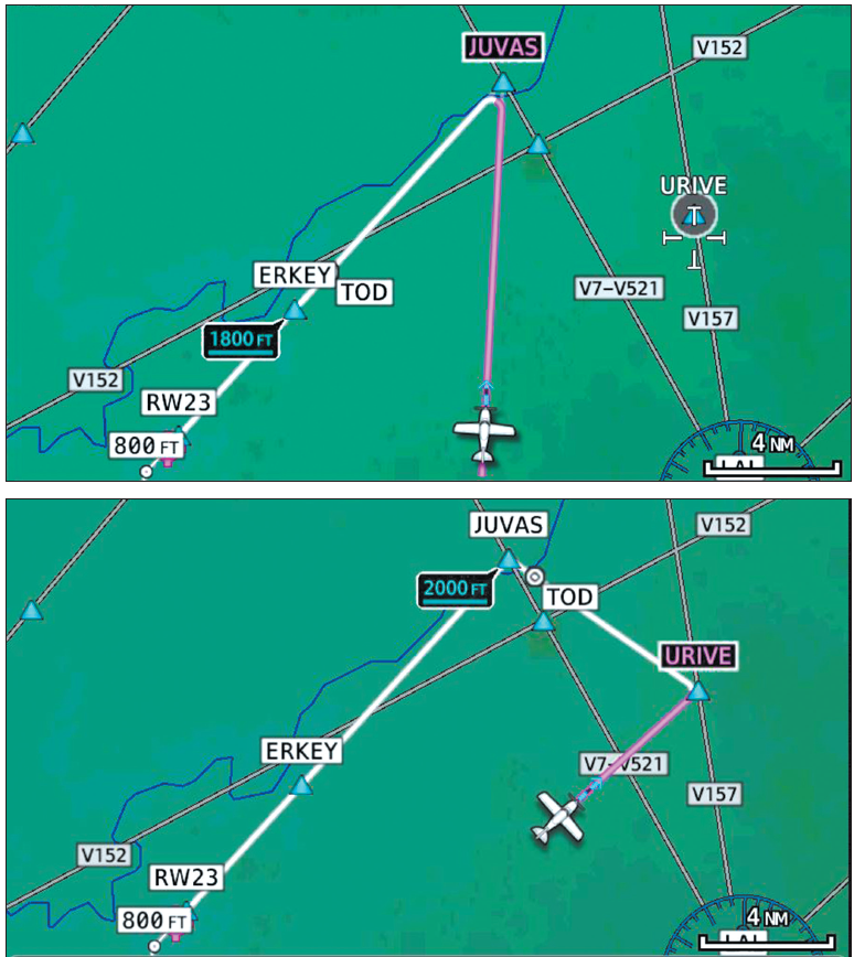
The Error-Evident Display
A moving map is a magnifying glass for catching preflight and inflight errors. Flying with Amy during an IPC, she confused JUVAS intersection with URIVE on the RNAV 23 at KVDF in Tampa, FL. The error was obvious, as the map shows.
Incorrect waypoints can be hard to find among a list of waypoints. Such mistakes are easy to detect on the map if they are large enough to be visible.
Callouts for Course Intercepts
During a course intercept, you can prevent two frequent errors by asking and answering two simple questions.
Where am I going? Amy should have pointed to the active waypoint on the navigation page to assure herself that JUVAS was correct. When she didn’t, the map showed something was amiss.
How am I getting there? To initially turn in the correct direction, Amy set the heading bug toward URIVE, then enabled HDG mode. She entered URIVE into the flight plan and switched back to NAV. Amy used a lower, faster level of automation until a higher level became appropriate. Nice recovery, and there was nothing for ATC to notice.
Use Armed Modes
Last month, we noted that humans have difficulty remembering to make a needed change in the future. Armed modes can help relieve some of the burdens. Two examples: First, let the armed altitude-select mode relieve you from having to hit ALT once reaching the desired altitude. Second, during a course intercept, arm NAV while in HDG mode so the autopilot will smoothly join the course. Note that not all autopilots support all armed modes.
Get Behind the Airplane
That’s what happens when a pilot loads the first en-route waypoint before takeoff, hits Direct after launch, and expects to enter the balance airborne. This time detracts from flying the airplane safely during a critical phase of flight.
These days it’s easy to get your clearance before takeoff. Cutting this corner adds risk to save just a few minutes. Instead, if you can’t load the entire flight plan, at least load several waypoints on the ground and enter the rest when comfortably at cruise. But, there’s still a risk you’ll forget.
Rushing and airplanes don’t mix. The rush to enter the flight plan can more readily lead to errors, perhaps dangerous ones. The best strategy is to enter and check all the waypoints before departure. As carpenters say, “measure twice; cut once.”
Back Yourself Up
Savvy pilots select the best route from searches on two or three flight planning tools. They look at past and preferred routes and often build their own. There is hardly a better way to get your head into trip planning.
Most flight planners support blockto- block flight plans. Distances, times, and fuel usage should cluster around a few values. Thorough preparation precludes many errors.
Airborne, use the VORs to cross-check your location and maintain situational awareness. Fly occasional ground-based approaches to maintain your proficiency should GPS go dark.
Spatial Reasoning
Pilots who learn to navigate using VOR needles are forced to develop three-dimensional spatial reasoning and visualization skills. However acquired, these skills help catch errors before they happen, such as looming traffic conflicts, incorrect ATC instructions, and adverse weather movement.
Moving maps undercut the development of mental position-finding skills. An FAA study showed that disused spatial- reasoning skills fade fast. Visualize where traffic is located before you look at the map. Where is the airport, a VOR, a visual checkpoint? Try to build and keep your three-dimensional spatial reasoning and visualization skills sharp.
Direct to Danger
A GPS always starts navigation from its present position. Direct-to navigation will build a new track from your current location to the specified waypoint. Do not fly the route until you’re sure there are no dangerous obstructions, terrain, weather, or airspace in the way.
Fuel Emergency
According to at least one cynic, fuel emergencies begin at engine start. If so, get ahead of it. Measure fuel consumption with a tank gauge calibrated for your airplane. Divide by engine running time at lean cruise power to get hourly fuel flow. Repeat a few times. Compare the average result to the POH and the rate calculated by on-board fuel management tools to derive a sensible figure. Enter it and the fuel aboard into your GPS. Now you are ready to make informed fuel-related decisions.
If the fuel management function or system’s numbers differ from what is pumped aboard, investigate. Improper leaning, wind effects, and inaccurate EGT/CHT gauges could all be a source of a discrepancy.
We calculated the flow rate in a Cessna 182 during a long trip to Oshkosh. On the return flight, it was plainly higher. We landed short and discovered a small fuel leak. Awareness of the flow rate helped prevent a fuel emergency.
Terrain Awareness Warnings
While a full-up, certified Terrain Awareness Warning System (TAWS) usually comes with a hefty price tag, most GPSbase systems have some perfectly usable non-certified means to alert you when you’re approaching high terrain. Let’s generically call them all TAWS.
Do you expect to land at a private or unpublished airport? Anticipate a possible TAWS alert on approach. Know where to find the Terrain Inhibit button. The last distractions a pilot needs on a known-safe approach are repeated and increasingly dire, “Terrain! Terrain! Pull UP! Pull UP!” warnings during landing.
Pilots have canceled or ignored valid “nuisance” alerts based on nothing more than intuition. If in doubt, perform the escape maneuver with full power and climb at VX or VY or whatever your AFM/POH or manuals suggest.
TAWS is not a terrain-following system. Leave the nap-of-the-earth stuff to the military.
Risk and the Limbo Bar
Each of us has a level of risk tolerance beyond which we don’t care to go. Some pilots are okay with circle-to-land approaches or IFR at night, others not. Some believe an airplane won’t fly without full tanks.
Psychologist Gerald Wilde recognized our tendency to set target levels of risk like a limbo bar (my analogy). Advanced avionics can insidiously lower the bar because we know more and guess less.
Citing an FAA example, say a terrain display gives you the same sense of risk at a 1000-foot ceiling as you had at 1500 feet without terrain warning. Does that perception justify lowering your limbo bar to 1000 feet? Why “give away” 500 feet? If that’s valid, why do a stubbornly high number of CFIT accidents continue to plague our community? Would it not be safer to leave the bar where it is?
Most pilots quickly grasp that a TAA or even ADS-B on an iPad markedly elevates their situational awareness (SA). Smart pilots apply this better SA to improve decision making, avoid risks like severe weather and traffic, and stay ahead of the airplane. Wittingly or otherwise, a few press the technology beyond its limits, perhaps trusting satellite weather to bob-and-weave between red splotches or having unwarranted faith in the fidelity of terrain maps.
It’s a Wrap
As we conclude this series, we hope you benefit from the shared ASRS experiences in Part I by pilots who tempted fate through incompetence, mission mindset, and busting regulations. Knowing the essential skills of GPS in Part II helps you zero in on what you need to know. Essentials step seamlessly into learning the nice-to-know.
We took advantage of FAA and NASA studies that identified common errors in advanced avionics in Part III and ways to forestall them here.
Advanced avionics help pilots avoid hazards, but shouldn’t be used to operate closer to the edge. Don’t allow the confidence-inspiring precision of sophisticated avionics lure you into feeling invulnerable. Instead, use that advanced capability to help you become less vulnerable.


