
Heading out to the ramp, we approach the Mooney in the darkness. The weather is cold and damp. You, the reader, are coming along for a ride. It is Dec. 8, 2013, a little after 9 p.m. We’re flying out of Melfa, a little airfield about an hour north of Norfolk, Virginia. Our destination: Steel City, Pittsburgh. It’s not the best weather for flying, but our friend Dave got last-minute VIP tickets for the Backstreet Boys/Avril Lavigne show at the Petersen Center tomorrow and called in a favor. He’ll be riding in back.
The route we’ve chosen brings us from the Delmarva peninsula northwestward, just west of Washington DC, across the panhandle of West Virginia into southwest Pennsylvania. We filed for 6000 feet, hopefully over the weather that is producing winter storm warnings and headlines about the ice storm. The precipitation across Virginia is light, and though we won’t be in any icing conditions, the Mooney’s TKS anti-ice system gives us a comforting margin of safety.
It’s a cold December evening in Melfa and the ramp is wet. The temperature is 34 degrees, there’s no weather, and departure should be routine. The bright beam of the flashlight yields no issues on the preflight inspection. We climb in, double-check we have everything, fire it up and call for our IFR clearance while the temperatures stabilize.
We taxi out, and a little after 0230 UTC we lift off Runway 3, quickly entering the overcast. Washington Center acknowledges radar contact as we climb, seeking out the 323 degree radial from Cape Charles. We pass through 5000 feet and make a slow turn northwest toward Pittsburgh.
Bad Weather on the Horizon
Our airplane isn’t the newest on the ramp and the panel is a classic, save for the Garmin 430W. Wisely you brought along a portable XM Weather setup. You pop the antenna onto the glareshield, turn it all on, and start the app. The data starts flowing and we’re soon awash in weather information.
“How ‘bout we pull up the radar?” I ask.
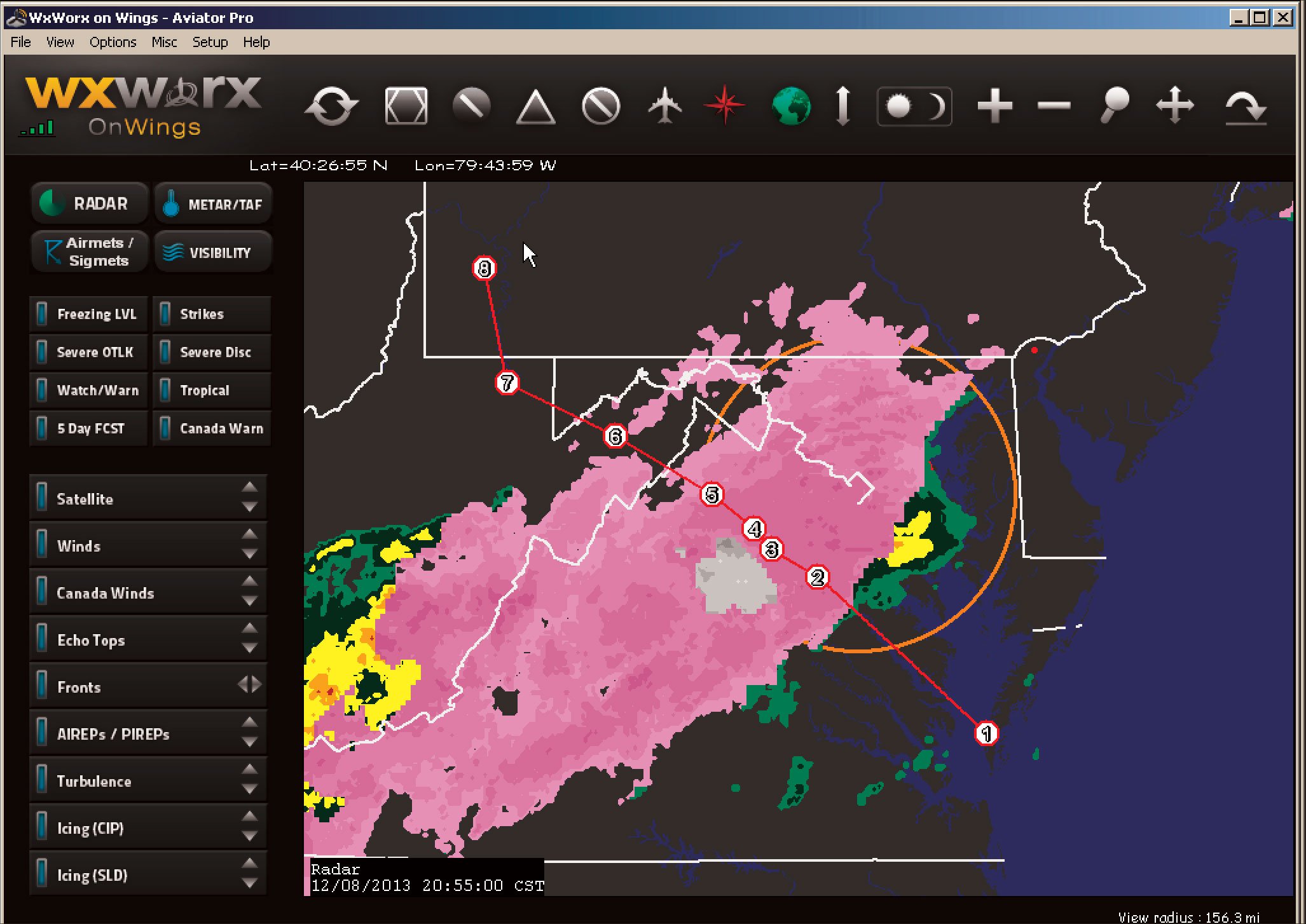
You click on the radar button, and we see a large area of pink ahead (Figure 1). It definitely looks a bit questionable. Pink colors on a radar presentation, by convention, indicate a region of transitional precipitation, specifically freezing rain, freezing drizzle, and sleet (ice pellets), while gray is reserved for snow.
It’s important to remember several things when we view this product. First, of all, are we looking at base reflectivity or composite reflectivity? This isn’t always clear, but they are two fundamentally different radar products and it is absolutely worth your while to find out which one you’re using. Base reflectivity is what the radar shows from a single elevation scan, normally with the antenna pointing about a half-degree above the horizon. So it shows precipitation intensities close to the ground. Composite reflectivity is an enhanced radar product that looks at all elevations—up to 14—to determine the maximum detected intensity in a vertical column above a given point on the earth’s surface.
XMWX satellite weather and ADS-B currently use composite reflectivity. On the other hand, WSI InFlight uses base reflectivity. Both are excellent products. Base reflectivity more accurately shows conditions in the traffic pattern and on the ground, and will show familiar severe weather signatures like hook echoes, which will be largely masked on composite reflectivity. On the other hand, composite reflectivity integrates data at all levels, and any intense precipitation that exists at cruise level will likely be detected and displayed.
What does this mean for us? We’re seeing intense shades of pink ahead.
Drilling down, we see that some of it is almost 40 dBZ, suggesting moderate precipitation. This could exist at our altitude, but, we can’t be certain. But, we know that if we go around it, the echo-free areas are almost a guarantee of no precipitation. With base reflectivity we can’t be certain.
What about the color zones? These are not determined by the radar. Though the modernized polarimetric radar network does have the ability to discriminate between precipitation types and even has a product that actually shows expected precipitation types at the surface, none of this has yet made it into the aviation data streams. With XM Weather, Baron examines the temperature field reported in METAR reports, and if any of it is at or below freezing, the radar elements at those locations are shaded pink or gray. Sites that are exclusively reporting snow receive the gray shade.
Icing on the Cake
You glance over and say, “I guess we’d better get an update on the icing, huh?” The outside air temperature is 5 degrees C—at the moment. Will we fly into a frontal zone, only to have things go downhill?
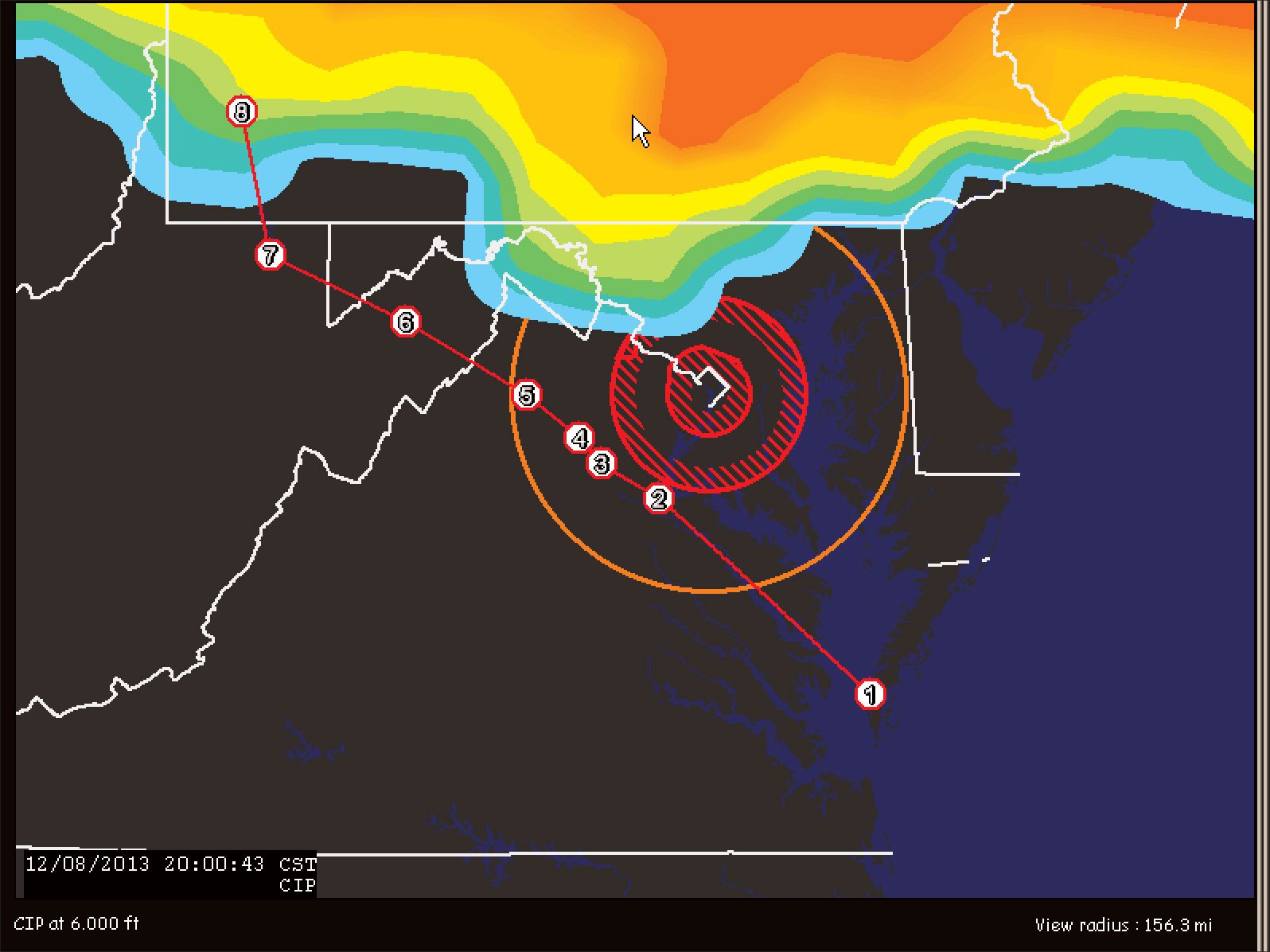
Our briefing didn’t indicate any risk of ice at our chosen 6000 feet. The XM Weather icing chart (Figure 2) still confirms this. However an old saying says “trust, but verify.” It’s sage advice on this cold December night, since without a current understanding of conditions, an unexpected change along the way could spell trouble.
There is little in the weather lineup to confirm the clear passage at 6000 feet. However during our briefing we decided to print the FDUS1 product (Figure 3), which is available at the Aviation Weather Center under Winds/Temps Text. This is a carefully controlled forecast product that was used to produce faxed charts for dispatchers, FSSs, and FBOs until the 1990s. It shows winds and temperatures aloft. The Aviation Weather Center now puts other charts on their website for this purpose, but they’re a little hard to read sometimes and these text tables provide solid forecast guidance. Tonight’s weather shows that along our route, temperatures will be entirely above freezing at 6000 and even 9000 feet. It’s only if we climb to 12,000 feet will we risk icing, particularly near our destination.
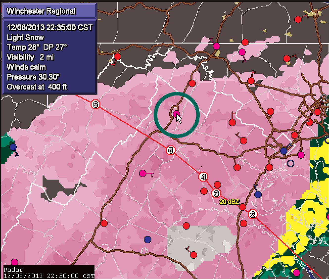
So what’s up with all this pink up ahead? Checking the METAR observations (Figure 4), we can see that temperatures range from 28 to 32 degrees F, and snow and freezing rain are being reported. Things may indeed be a little problematic in that area if we have to descend into it.
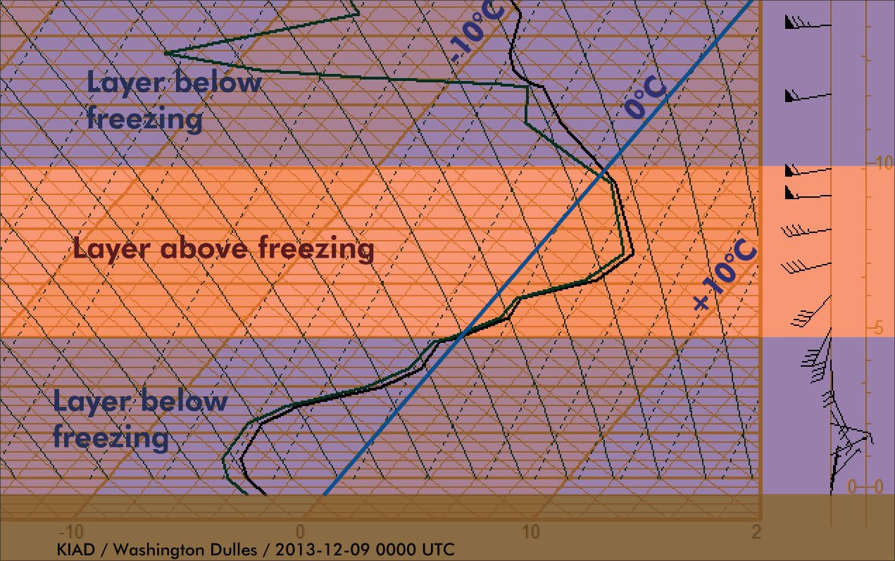
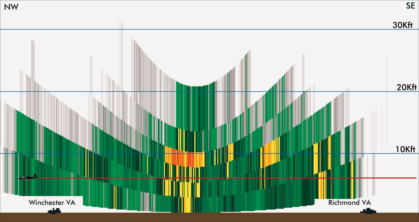
The puzzle is revealed by the meteorological sounding (Figure 5), which is the atmosphere as a forecaster would see it. This is actual observed radiosonde data, and is simply a plot of temperature (X-axis, slanted) and altitude (Y-axis). Reading the temperature (the right line of the pair) we see there is a layer of cold air from the surface up to 5000 feet, a warm layer above that which is warmest at 7500 feet, and then cold again at 10,000 feet. The layer of cold air near the surface is essentially stagnant polar air that was trapped east of the Appalachians, and is now being eroded as strong southwest winds in the 5000-10,000-foot layer increase. Things are bad down low, but conditions should improve.
Reading soundings is beyond most pilots, but it can be done. I learned them at age 13, so anyone with enough will and patience can certainly learn what they have to offer. By learning the basics of soundings and using sites offering them like
Topping the Rain
Rain has gradually been picking up during the first half hour of the flight. As we reach Casanova, it’s smashing against the windshield with a relentless clatter. It’s reassuring that the temperature has inched up to 6 degrees C, so there is still no icing danger.
You ask, “Can we climb above this?”
The echo tops product shows tops of 25,000 to 40,000 feet. However compared to the original NEXRAD (Figure 6) this appears overly pessimistic, and may be more representative of the cloud tops than the precipitation top.
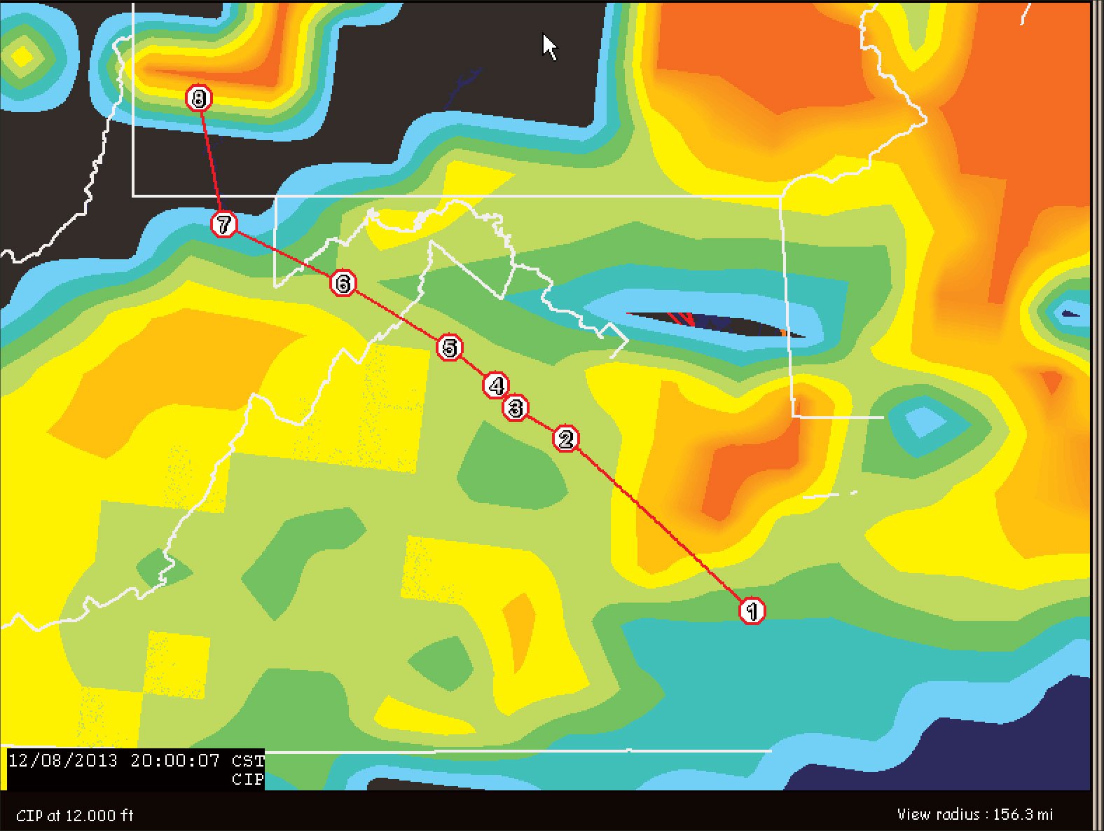
Actual precipitation tops range from 11,000 to 20,000 feet. We could climb up to this level and get out of the heavier precipitation, but as the temperature products above show, this would put us into the ice. This is confirmed accurately by the XM Weather’s Current Icing Product for 12,000 feet (Figure 7), which shows a moderate risk of icing if we climb to that level.
Fortunately the precipitation tapers off and we fly through broken to overcast layers all the way to our destination. The METAR report indicates the freezing drizzle has cleared out, and it’s 32 degrees F with IFR conditions. Not much different from conditions where we departed. We shoot the Runway 10 ILS approach uneventfully and make a safe landing.
Stretching after the long flight, you and I tie the plane down while Dave tries to get the rental car. We need to find that guy some Radiohead tickets.
Tim Vasquez is a professional meteorologist in Norman, Oklahoma. XMWX satellite weather is available on many devices and apps, and each adds their own interpretation. For this series, Tim uses WxWorx on Wings, a PC application from the data provider for XMWX.


