
The U.S. pilot population doesn’t have a good track record with weather safety. Inadvertent VFR into IMC was responsible for over half of 2010’s 55 weather-related accidents, of which 83 percent proved fatal. Projections are for that to get worse. Do we just not see the weather coming, causing us to innocently fly where we shouldn’t?
Well, a proper pre-flight briefing for a proposed flight should expose the biggest hazards to avoid, but perhaps many of us are getting into trouble with the age-old tradition of taking a look. In addition, it is reasonable to say that the preflight weather data we get might not be current by the time we get to the problem spots, further encouraging us to launch and take a look when we get there. Wouldn’t it be better if we could easily get a thorough view of the weather from the cockpit?
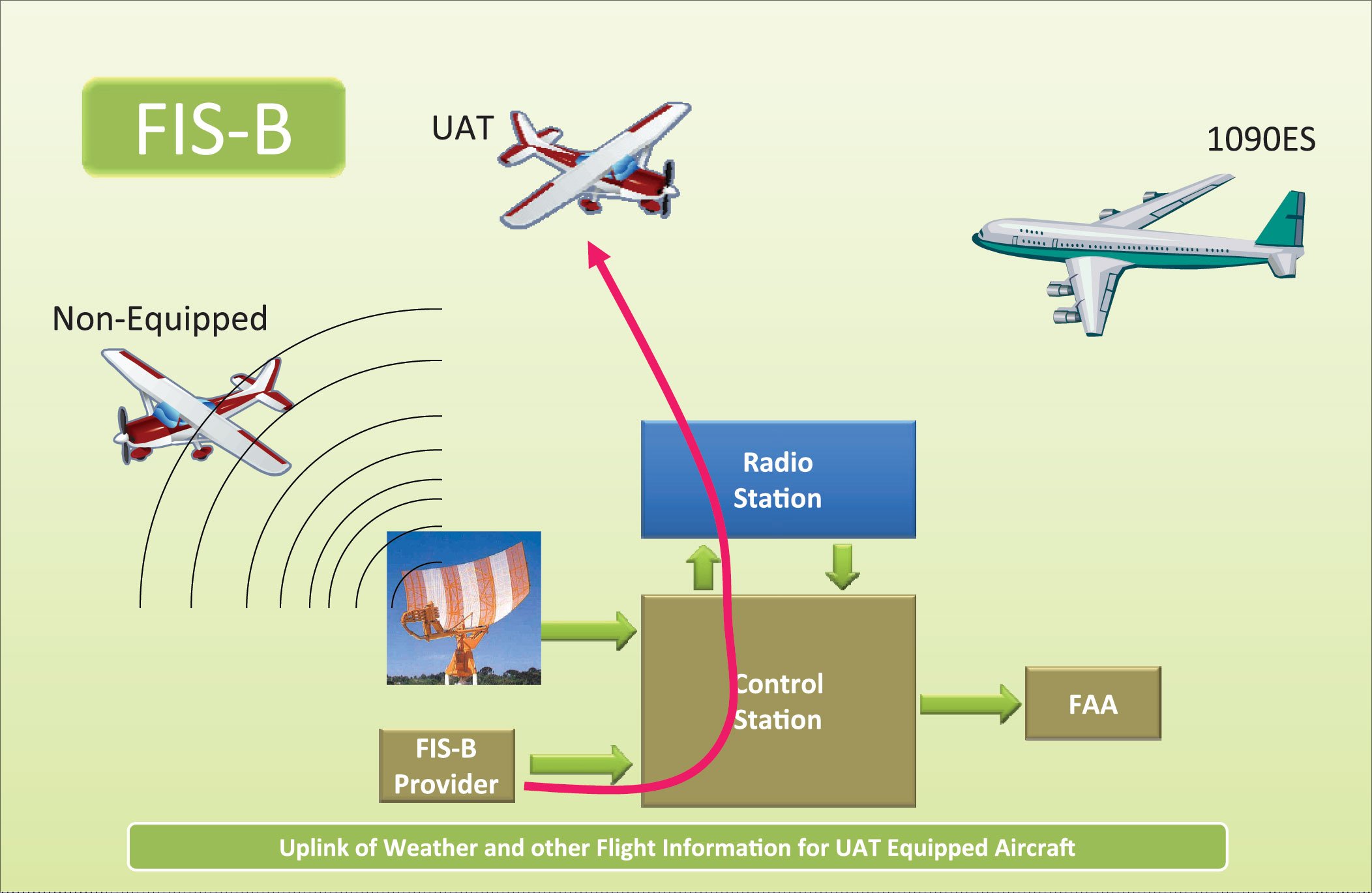
WxWorx, now through Sirius XM satellites, has provided weather graphics and charts to the cockpit for some time. Now, the FAA is getting into the act with a component of ADS-B called FIS-B (Flight Information Service-Broadcast).
There are significant differences in the breadth, depth and format of each service, as well as important differences in the way each delivers the data to you. Let’s take a look at each service to help you figure out which might be best for the kind of flying you do.
Going Head-to-Head
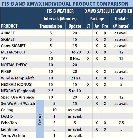
The table below compares FIS-B weather to XMWX. There are 11 FIS-B products at this writing, with six more in the offing. Of these 11, four similar XMWX products are available in the basic LT package, but five need at least Aviator. NOTAMS-D/FDC, offering Distant NOTAMS and Flight Data Center information, is offered only by FIS-B. Think of FIS-B as halfway between the XMWX LT and Aviator packages.
The FIS-B products should generally be familiar, but the future product, D-ATIS, deserves a special mention. At many larger airports, the ATIS is still broadcast on VHF, but is available electronically to specially equipped aircraft.
This “digital ATIS” is therefore available beyond the VHF voice ATIS transmitter range. This allows you to get weather, more up to date than the METAR, but you can also find out the runways and approaches in use well in advance.
XMWX offers additional products itemized in the second table, many of which provide weather coverage in Canada. Four come with LT; four in Aviator and seven require Pro.
Products specific to XMWX call for explanation. All packages offer National Weather Service City Forecasts, giving an overall view of predicted weather for large U.S. cities via a small graphic showing predicted sunny, partly cloudy or rainy weather. Beside the graphic, predicted high/low Fahrenheit temperatures are shown.
All packages offer County Warnings. Generated by the NWS, warnings are shown as small colored circles. They include tornado threats, thunderstorms, floods and flash floods.
Aviator LT does not include AIRMETs or SIGMETs. Flight Watch on 122.0 offers that information and more.
Moving up to the Aviator package, Echo Tops show the maximum height of precipitation in cloud, meaning that a cloud could be much higher without containing any precipitation. Higher tops imply a stronger storm with attendant turbulence and updrafts. Flying over the top of a cloud can be a trap, since ice may be present but too small for radar to detect.
The Freezing Level shows graphic contours identifying areas and altitudes with temperatures around zero degrees Celsius. This helps make escape or better yet, avoidance, of icing conditions possible because the freezing layer is usually just a few thousand feet thick.
Severe Weather Storm Tracks use arrows to show stronger storm’s forecasted speed and direction, wind shear and hail size probability. Since these can change rapidly, updates happen every 75 seconds. These can help you predict and avoid where the nasty weather will be when you get there.
The Surface Analysis weather map shows ground-level high and low pressure systems. High pressure means better weather; lows often mean clouds and precipitation. The map also shows warm fronts, cold fronts and their direction. Offered in 12-hour forecast increments out to 48 hours, they’re a great way to assess trends and where clear weather is likely along your route. In an emergency, it can provide a quick escape to VMC.
Satellite imagery shows where and how high clouds are. Tops are determined by measuring their temperature from NOAA geostationary satellites. Shown in 5000-foot increments, the G1000 offers eight levels of cloud heights.
The lightning product (a FIS-B future offering) collects only cloud to ground strikes, which constitute only about a fifth of all strikes and mark the dissipating stage of a thunderstorm. Updates occur every five minutes. An onboard spherics detector can additionally collect internal cloud strikes that often occur during a developing thunderstorm. Accordingly, you could use the datalink to see if a storm is dissipating and your onboard equipment to see if one is building.
XMWX is a tale of two vendors: WxWorks provides the weather products to XM who uplinks it to satellites that then downlink to you. Data comes from multiple sources. For example, WxWorx updates its Winds Aloft (FD) product hourly, compared to 12 hours from the NWS. XMWX wind speed and direction are given from the surface to 42,000 feet in 3000-foot increments. This lets you hone in on the “sweet spot” altitude with the best winds rather than fly-and-try.
Aviator Pro adds seven products. Clear Air Turbulence predicts light, moderate or severe turbulence in 3000-ft increments from FL210 to FL450.
The Visibility product graphically shows where estimated visibility is under 10 nm, and then in 1-nm increments. Hurricane Tracks offers an incremental five-day forecast of hurricane location, strength, wind speed and direction.
Produced by the NWS/NOAA Storm Prediction Center, Day 1 Convective Outlook text summarizes predicted severe thunderstorm threat levels as slight, moderate or high across the 48 states. It includes a Mesoscale Discussion that points out severe weather threats, sometimes including heavy rain or convective activity, before a watch is issued.
Finally, the Current Icing Product classifies the current likelihood of icing in five severity levels from none to heavy by altitudes from 1000-30,000 feet in 3000-foot increments.
Delivery System Differences
With XMWX, the satellite data stream continuously broadcasts all the data products. So, when you first turn on your receiver, it’ll only be a short interval before you have all the subscribed information.
FIS-B products are only broadcast periodically—the transmission interval. When you turn on your receiver, it can be up to 15 minutes before you see your first CONUS NEXRAD, for example.

The update intervals in the chart show how frequently the information is updated with fresh data.
FIS-B uses ground-based transceivers to establish a data link with universal airborne transceivers, UATs. You must be at least 1000 feet AGL within 37 nm of a UAT to receive it. Transmission is line-of-sight. Range is 150 to 200 nm to FL240 and even higher.
Currently 529 ground stations provide FIS-B (and traffic information, TIS-B). The mountainous U.S. west is awaiting ground stations. Installations planned in 2014 will make a grand total of 663 ground stations nationwide.
Receiving FIS-B on the ground is unlikely without a nearby ground station. Of course, XMWX satellite weather is available anywhere your antenna has a view of the sky. Most of the apps supporting FIS-B and XMWX also support cellular data connections on the ground.
The availability of critical weather information in the cockpit has never been greater. XMWX has long been the only player. Now, the addition of FIS-B products further enhances our airborne weather decision making capabilities and choices. FIS-B provides some compelling advantages for many pilots. But with a broader range of detailed weather information from XMWX, its greater availability and its data for Canada, it’s likely that serious all-weather and long-distance flyers will continue to rely on it for a long time.
I’d like to thank Shelby Keefe at the FAA for crucial documents I would never have found otherwise, and contractor Jane Lee Lopez who provided unpublished up-to-the-minute ground terminal information explaining the western gap.
Fred Simonds, a Gold Seal CFII, loves fiddling with cockpit weather while his students sweat. See his web page at www.fredonflying.com.
Low, Medium and High
To better use FIS-B bandwidth, ground stations are organized as cells and configured to serve high-, medium- or low-altitude “tiers” of users. Obviously, there are far more stations serving low-altitude than high, simply due to the number of users and the line-of-sight radio range. FIS-B provides look-ahead ranges by product to best serve aircraft by tier. For example, the winds and temperature aloft look ahead is 500 miles for the low-altitude tier, 750 for medium altitude and 1000 miles for high altitude.
Service for high-altitude users runs from the surface to 24,000 MSL, the nominal upper limit of FIS-B. This tier serves turbocharged or turbine GA aircraft, and airliners in climb/descent and lower cruise altitudes.
Medium-altitude users include aircraft operating from the surface to 14,000 AGL, thereby including most piston aircraft. It also includes airliner departures and arrivals.
Low-altitude users include those from the surface to 3000 feet AGL, serving all aircraft in the terminal environment. CONUS NEXRAD imagery is not offered to the low-altitude tier, but regional NEXRAD is.
Surface-tier radios will be located at Class B airspace airports supported by Surveillance and Broadcast Services listed in Part 91 Appendix D. —FS
Lease vs. Buy
The entry prices for FIS-B and XMWX are similar. A portable receiver setup for XMWX costs about $1000. Spending that on a FIS-B receiver will leave you with some change.
FIS-B data requires no subscription. It’s free—at least until the FAA finally gets user fees. XMWX data is available in three levels as depicted in the accompanying tables: A $35/month LT subscription buys eight weather products; $55/month for Aviator gets you 22; $100/month Pro buys all 29. Both FIS-B and XMWX need an app subscription, typically under $100 a year. Of course, there are panel-mount options as well, but those require much deeper pockets for the hardware.
Clearly, FIS-B is cheaper by up to $1200 per year, depending on your data needs. For many pilots, FIS-B is sufficient and offers the benefit of—potentially limited—traffic information (TIS-B) at the same time. Pilots who fly “gentleman’s IFR” through puffy cumulus clouds will be happy with either FIS-B or the XMWX LT package. Pilots flying harder IFR frequently in poor weather make the XMWX Aviator a good fit. Those who fly low IFR, professionally, often at night, in high terrain or at high altitude, in areas of consistently bad weather, need the all-weather capability of XMWX Aviator Pro. We don’t think it’s a stretch to imagine some hard-core pilots opting for both FIS-B and a subscription to Aviator or Pro. If you need data for Canada you need XMWX. —FS


