
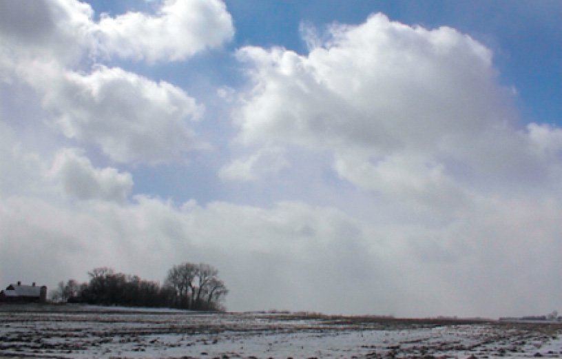
Now that winter is upon us, it’s a good time to look at cold-weather patterns and get an idea of what to expect. You may be familiar with the weather around your local airport, but your travels could take you into unusual corners of the United States, and perhaps into Canada. Winter brings a huge number of weather hazards to worry about, including the thunderstorms that plague the summer months, but by understanding how things are linked together, you can stay on top of things and remain safe.
It’s All About Air Masses
Not surprisingly, the primary factor driving winter weather is the absence of strong heating. The dynamo that drives the earth’s circulation, the sun, shifts to more southerly latitudes. By this, we mean that the latitude where the sun is overhead at solar noon moves southward, passing the Equator in late September and reaching almost S23.5 degrees several days before Christmas. Consequently, solar angles in Minneapolis never reach higher than 22 degrees above the horizon, and in Seattle the sun is only 19 degrees above the horizon! The ability of the sun to heat the ground diminishes dramatically as the solar angle decreases.
This means that Canada, where solar angles are low or even negative, becomes a polar air factory. The ground has lots of thermal mass and receives some heat from the depths below, and its equilibrium temperature ranges from just below freezing in northern Canada to the 30s and 40s in southern Canada. Much of this heat is radiated away into space as long-wave energy. However the ground is frequently covered by blankets of snow. This acts as an insulator and “shuts off” the heat, allowing the air mass to radiate its own heat away.
Forecasters then say that a polar or arctic air mass is being produced. As the temperatures fall and the air becomes dense, the surface pressure rises. In very cold air masses, altimeter settings will frequently rise above 30.60 inches. The record for the Lower 48 was set on Christmas Eve 1983 in Miles City, Montana: 31.42. Does your altimeter go that high?
These high-density air masses, behave exactly like a large blob, expanding outward in all directions—most readily toward lower-density air. So within a couple days the polar air masses quickly steamroll their way southeastward or southward, bringing northwest winds of 20 to 30 knots. The air masses are usually preceded by “Alberta clippers” that are minor low-pressure systems producing snow showers that normally only leave small accumulations.
A typical Alberta clipper forms in Alberta and tracks toward Ontario or the Great Lakes, on rare occasions reaching as far south as the Ozarks. As the cold front sweeps across the eastern and southern United States, the only perceptible weather is a wind shift, clearing, and gusty northwest winds.
The Cold Blast Follows
These Canadian cold fronts are followed by polar highs that originate from Yukon or the Northwest Territories, moving southeast across the central or east United States and weakening, absorbing themselves into the semi-permanent Atlantic high pressure. These polar highs represent the core of the polar air. These air masses are extremely cold; in some of the coldest outbreaks, daytime high temperatures can range from well below freezing in Minnesota and the Dakotas to 10 to 20 degrees F in Arkansas and Texas.
These air masses gain lots of heat from below as they move southeast over relatively warm terrain. This is important to pilots, because it produces a pronounced “cold-over-warm” layer in the lowest mile of the atmosphere—in other words, very strong instability and a steep lapse rate. The atmosphere works vigorously to overturn and equalize the cold polar air 2000 to 4000 feet above the ground, mixing it with air near the ground that picked up warmth from winter sunlight and the ground’s thermal mass. This acts to bring cold air to the surface and diffuse the warm air aloft.
This process produces extensive mechanical turbulence and low-level wind shear from the ground up to about 5000 feet. If it’s a bumpy ride, you can usually get above it by climbing, as long as you aren’t downstream from a mountain range. If there is enough residual moisture, some cold cumulus and snow showers can develop, but this kind of precipitation usually dissipates around sunset. Thankfully visibility is almost always excellent, and ceilings are unrestricted or MVFR at worst. If you can handle the crosswinds and turbulence, you should be fine in the Canadian weather systems.
Pacific Air Masses
Pacific air mass outbreaks are different from the Canadian polar air masses. It’s valuable to learn to differentiate the two. Pacific highs have their origin from the Pacific Ocean, and are preceded by a low pressure system that makes landfall on the West Coast. Initially the low pressure makes landfall in British Columbia or Washington, but new lows further south along the cold front develop and produce low pressure systems in California, Oregon, or Nevada.
A typical event takes place in California. Strong west or southwest winds affect the state, with increasing clouds and low ceilings. Heavy rain falls in northern California, and IMC blankets the San Francisco Bay Area to Sacramento. As the surface low and the cold front passes, winds turn to westerly or northwesterly, and conditions rapidly improve. Frontal passages in California can be very difficult to identify from METAR observations and maps, and sometimes NOAA surface maps inaccurately depict the fronts. Keep an eye on wind shifts, pressure trends, and dewpoint changes. These are the keys to spotting frontal passage in California.
Downhill in the Rockies
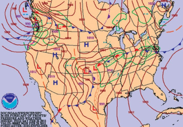
The low pressure system then begins its trip across the Rockies. Low pressure moves from California or Nevada into Utah, Arizona, or Wyoming. Consequently, Salt Lake City and eastern Nevada can see some heavy snowfalls, with snow possible even in Las Vegas. As these systems move east, Pacific air filters westward across the Sierra Nevadas and the Great Basin. Maps show a 1020 to 1030 mb high improving the weather. If the Pacific air mass joins cold Canadian air that is deep enough to cross the Rockies southwestward, a major winter storm for the Rockies and intermountain region can result, with fierce northeasterly winds in the passes.
As the low pressure reaches the Rockies, the real fun begins. Strong winds aloft cause an intense lee-side low to form, typically in eastern Colorado but sometimes further north or south. This causes widespread southerly winds across the Great Plains south into Texas. This can “tap” the Gulf of Mexico and start bringing moisture northward. When this happens, the dewpoints begin rising from the 30s upward to the 50s and 60s, with warm, muggy tropical air.
As the cold front reaches the Front Range, winds in the High Plains are very intense, with sustained southerly or southwesterly winds of 30 to 40 knots gusting to 60 or more. This air, from the interior deserts—sometimes containing dust—clashes with the tropical air in Texas, producing a dryline. This forms the western edge of the moist tropical air.
The front then emerges, bringing a wind shift. West or northwest winds arrive and weather improves. Numerous high-based showers develop along the front. Some strong storms may develop further east along the dryline, but in the winter the cold front tends to rapidly move eastward and “swallow up” the dryline somewhere around Dodge City to Abilene. Once this happens, deep showers and thunderstorms form, commonly producing a squall line in Kansas, Oklahoma, and Texas. The weather within this squall line may range from weak high-based showers to intense severe cells with damaging winds and hail.
This cold front moves eastward into the Mississippi River region. The original low pressure area from Colorado typically moves toward the Great Lakes, with a new low forming on the front along the Gulf Coast. Near either of these lows, precipitation is heavy on the northeast and northwest sides, and if the air is cold enough, it’s a ripe area for winter weather. This is when cities like Dallas, Memphis, Chicago, and Kansas City can get heavy snow or ice events that make national headlines.
There is also a major severe weather risk for the Gulf Coast region. Although we think of tornadoes as a springtime phenomenon, severe weather risk is at its highest point in the Southern states. In December and January, United States tornadoes are most common from east Texas to Georgia. These are typically formed from well-developed Pacific polar systems that have brought lots of moisture northward from the Gulf. If the surface systems are well-developed, they can deepen in the Gulf Coast and then track up the east coast of the United States, producing major winter storms in the Northeast.
Flight Level Winds
All of the weather we’ve covered so far has a tremendous impact on the winds aloft. A good rule of thumb is the jet stream winds—20,000 to 35,000 feet—follow the gradient between the synoptic-scale cold and warm air masses, with cold air on the left-hand side and warm air on the right. The intensity of the jet stream is proportional to the synoptic scale temperature differences.
By synoptic scale we are talking about features on the order of several hundred to several thousand miles in size, and with a life cycle of days. If temperatures are cold only in Iowa but warm in neighboring states, it doesn’t meet the synoptic-scale size requirement. Sorry, Iowa.
It follows that when a Canadian polar outbreak is underway, we’ll find the jet stream extending from western Canada into the central Great Plains and into the eastern United States. This puts much of the United States under a northwesterly flow. But with a Pacific system, a jet stream will extend from California or Oregon to the Midwest or Kentucky and Tennessee. So the Pacific outbreaks bring greater clear air turbulence hazards.
Clear Air Turbulence
The mid-levels, 10,000 to 20,000 feet, follow the synoptic-scale jet stream winds but are about half as strong. The region around 10,000 feet is a transition zone between jet stream energy and the low-level patterns, and the 5000 foot winds mostly follow the surface patterns.
Since the upper-level winds are a reflection of low-level temperature gradients, this means that wintertime brings a strengthening of the jet stream, and a shift southward from Canada into the United States. This is also when clear air turbulence (CAT) is maximized, particularly in the flight levels. Colorado and Utah, and adjacent areas to the west and northwest, are hot spots for CAT.
Look along the jet stream for the strongest horizontal and vertical wind speed gradients to find turbulence. If you picture the jet stream as a straight line going from your eyes into the page, hold out your left hand to form a “U” shape with the thumb tip just below the jet core, and the first or second finger knuckle just above the jet core. Your hand represents the region of strongest CAT. In the southern hemisphere, just use your right hand. There’s more detail in “Why It’s So Bumpy” in February 2017.
Other Dangers
Wet ground from recent rains, light winds, and clear skies are the trifecta for radiation fog. You’re most likely to encounter this in the southern and eastern United States after heavy rains that come from frontal systems that have just passed, being replaced by a high pressure that’s now moving in. Fortunately the radiation fog is fast to break up once the sun comes out.
Beware of a return flow of moisture on the Gulf and Atlantic Coasts. When cold polar air has been over these areas and then a warm southerly flow begins in advance of a weather system to the west, stratus and stratocumulus clouds are brought inland. The worst problems will occur at night, and this is when the clouds are difficult to see on infrared satellite imagery.
Valley fog is a big problem in the northwestern United States. A cold polar high, high pressure or ridging aloft, and higher air mass humidity than normal are more likely to create these patterns. What’s worse is that they’re self-reinforcing.
The tops of the fog and stratus radiate away heat, strengthening the inversion with each passing night, and they can last days or even a couple of weeks. It takes a synoptic-scale weather system and a pattern shift to break up these nuisances. This type of fog may occur in western Colorado, northern Utah, northern Nevada, Wyoming, Idaho, Oregon, and Washington. Occasionally they may even occur in California’s San Joaquin Valley.
Hopefully you can now understand whatever winter throws your way. We’ve looked at the “big picture” view. When you get a TAF for your destination, take a look at the charts and consider the patterns above and whether everything agrees. If the weather patterns and the forecast are not consistent, then you’re more likely to encounter a surprise. It’s a really good cue to look at things more closely before you depart—speaking as a former aviation forecaster.
Stay safe.


