
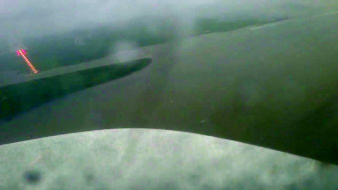
It’s the end of a long day filled of uncooperative weather, ground stops, and a diversion tossed in to make it interesting. You’re shooting the non-precision (of course) GPS approach, and upon reaching minimums, you look up and see … nothing. Wait a minute! Isn’t that a PAPI glowing out of the left side of your window? Is that your runway? If so, what’s it doingall the way over there?
This was the experience that a reader shared with us about flying the GPS RWY 12R approach into the North Las Vegas airport (KVGT). (See Readback, “Not There, but Over There.)”
It got us thinking about the sometimes overlooked value of briefing the sight picture that you should expect when breaking out of the clouds. When an approach is published with only circling minimums, we expect to look around for the runway. On a straight-in approach, the effect of aircraft orientation relative to the runway can be a little more subtle—and a lot more disorienting.
At minimums, in reduced visibility, approaching the visual descent point or missed approach point, you don’t have much time to go hunting for the runway. If you’re flying a vertically guided approach, you’ve got even less time once you hit the decision altitude and need to, well, make a decision. It’s far better to have a pre-planned notion of where your runway will be, if it shows up at all.
It’s All in the Angle
Obviously, when the nose of the aircraft is pointed somewhere other than straight down the runway, the runway is going to appear somewhere off to the side. This can be from ham-handed flying (difficult to plan around that), a final approach course offset from the runway, or even just a stiff crosswind. For example, on this approach the final approach course is 135 degrees, or about 15 degrees right of the runway, so you would expect the runway to appear roughly 15 degrees to the left of your nose. Add a strong right crosswind and, well, you get the idea.
On VOR or NDB approaches, the final approach course is frequently offset due to the location of the navaid. Before GPS approaches became widespread, thinking about how to make the turn from the final approach course onto the runway course was often a necessity. With non-precision GPS approaches, however, most final approach courses are perfectly aligned with the runway. Since most pilots will pick a GPS approach when given a choice, needing to handle an offset final approach course is typically not a skill that gets exercised often.
When the angle between the final approach course and the runway differs by more than 30 degrees, only circling minimums will be published. Of course, that doesn’t mean you can’t land straight in; it just means that separate straight-in minimums aren’t available.
A non-precision approach can be considered straight-in with offsets up to 30 degrees. That’s a lot. When the approach has vertically guided minimums, the maximum offset is three degrees for ILS and GPS approaches with LPV minimums, and 15 degrees for GPS approaches with LNAV/VNAV minimums.
Pilots and procedure designers both prefer the final approach course to be aligned with the runway since it’s the easiest to fly and permits the lowest minimums. So when you encounter a final approach course that is offset, there’s going to be a good reason. Usually it’s because of obstacles or terrain. Other times it can be offset for airspace avoidance or noise abatement.
What to Look For
Except on VOR and NDB approaches, offset final segments should have the offset angle shown in the plan view near the final segment (“Final approach course offset X.XX”) to cue the pilot that a straight-in approach isn’t perfectly aligned with the runway. We say “should” because there are still many approaches that haven’t been amended in a long time and were created before this note was required. Like, for instance, this approach into North Las Vegas.
If you encounter a somewhat-uncommon LDA (localizer-type directional aid) approach, it is effectively the same as a localizer approach with an offset that exceeds three degrees. In rare cases, LDA approaches can also have a glideslope component, making them functionally equivalent to an ILS with an offset of up to 15 degrees.
In many cases, to give you an opportunity to get lined up with the runway, the missed approach point of an offset final segment will be located along the extended runway centerline rather than at the runway threshold. The centerline crossing distance is typically less than one statute mile from the runway end, with larger offsets requiring a longer distance. On non-precision GPS approaches, if you notice that the missed approach point is a named fix rather than the runway threshold, that should be a cue that the final segment is offset or the design is otherwise non-standard. Usually the named fix will be the point at which the final approach course intersects the extended runway centerline.
An easy way to figure out where you’ll need to look for the runway when you break out of the clag is to compare your heading while tracking the final approach course against the runway course. “But wait,” you say, “the runway course isn’t shown on the chart.” True, but for our purposes, just add a zero to the runway number and call it good enough. Since runways are numbered according to their magnetic course rounded to the nearest 10 degrees, this method should get you within five degrees of the runway.
Another helpful way to visualize your expected orientation to the runway is to look at the final approach track arrow shown on the airport diagram sketch of your approach chart. However, this is only included when the missed approach point fits to scale within the sketch boundary, so it has to be close to the airport. Regardless of whether the track arrow is shown, use the sketch to prepare yourself for not only where your runway is, but where it isn’t. Know where the visual references for other runways are so hopefully you won’t be misled when the visibility is restricted and you just want to successfully complete the approach and land.
Proper Planning
When briefing an approach, it’s always a good idea to consider the difference between the aircraft heading on final and the actual runway course, and the anticipated sight picture that will result. So far we’ve been focusing on approach procedures that are designed with an offset final approach course, but in practice any approach’s sight picture at minimums can be impacted whenever there’s a strong crosswind.
For an aircraft flying an approach at 120 KIAS, a 20 knot crosswind results in a crab angle of 10 degrees, and at an approach speed of 90 KIAS, the crab angle is 13 degrees. This has the same effect on your sight picture as a final approach course offset by the amount of the crab angle. Consequently, a perfectly legal straight-in non-precision approach designed with a 30 degree offset to the runway, when flown with a 20 knot crosswind, could result in the runway appearing 40 degrees or more off-center. If you’re not fully prepared, that’ll be difficult to find, indeed.
The effective offset of the aircraft upon reaching minimums should be of particular interest to pilots relying on enhanced flight vision systems. An excessive offset could well result in the runway environment being outside of field of view of the pilot’s head-up display, and you might fly the missed approach with the runway visible if only you’d looked outside the HUD.
Although not quite as critical as the offset between the final segment and the runway, occasionally you’ll find an approach with an offset between the intermediate segment and the final segment. These approaches require a turn at the final approach fix, which can trip up inattentive pilots since the vast majority of approaches use a common course for the intermediate and final segments. Again, when approaches are designed like this, there’s likely a good reason, so consider it one more item to look for when briefing an approach.


