
Instrument approaches are designed such that several divergent paths and procedures funnel into one of a few common designs. Almost every approach you fly will either be a cone of narrowing vertical and lateral guidance; or a staircase of stepdowns to a minimum altitude.
Not so with departures. Here each runway is a potential departure point, plus there might be options for a visual climb over the airport (VCOA) to a safe altitude before heading on course. There are a theoretically unlimited number of potential routes. Designers must accommodate the infinite within the constraints of terrain, overlying airspace, potential climb gradients, and available navigation aids.
Sometimes they get creative.
Turn Here, Stop There
This month’s challenge isn’t so much difficult to fly, as it is easy to screw up the procedures. It requires planning. It requires pre-loading the next two instructions in your mind. It might require pulling back the power and slowing down for more time to think.
Start at Farmingdale, NY (KFRG), and imagine you’re flying for a small charter outfit that’s financially just barely hanging on. Today’s task is to jump over to Teterboro, NJ (KTEB), pick up a passenger and her briefcase, and deliver them to Lehigh Valley (KABE) in Allentown, PA. Fly something fast if you’re comfortable doing so. If not, try this sim challenge several times slow and then speed it up.
Set the weather to 500 OVC and visibility to one mile, with light winds at the surface. If you can, get random winds aloft. Tip: some sims let you do this by downloading real-world weather and then just changing the surface winds and clouds manually.
Runway 19 is in use at KFRG, and a phone call to the KTEB ATIS (thank you, A/FD) says they’re landing on Runway 6. Your clearance is to KTEB via the Farmingdale Five Departure, then Kennedy, V16, DIXIE, V276, Robbinsville, V249, Solberg. That’s a horrible routing, but at least it buys you some time to steel yourself for KTEB. You’ve heard stories.
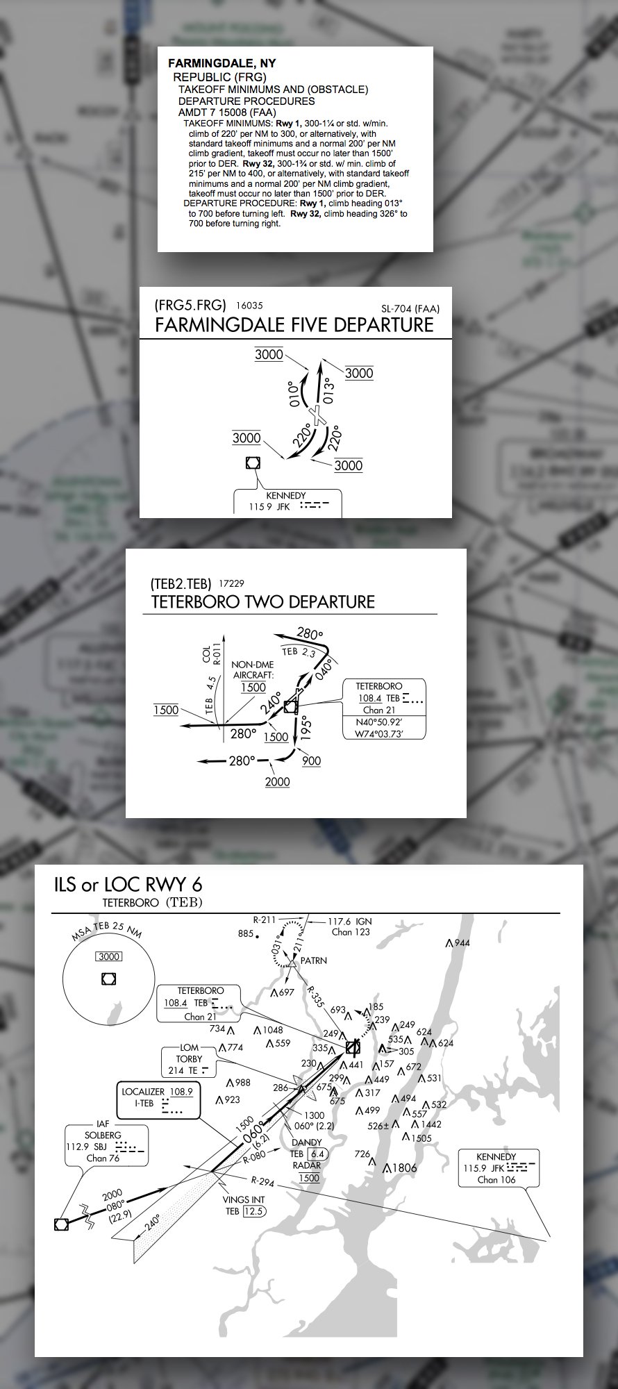
Taxi to Runway 19 and depart flying the FRG5 as published. After a minute leveled off and cruising, assume ATC instructs you to, “Fly heading 280. Join V16 and resume own navigation. Climb and maintain 5000.” At your leisure, throw yourself a bone and change that to direct Robbinsville.
ATC keeps you at 5000. Nearing Solberg you get, “Cross Solberg at 5000. Cleared for the ILS Runway 06 at Teterboro.” (Yeah, that would never happen in real life, but I can’t vector you onto final via a magazine.) They ask for maximum forward speed to DANDY. (That would happen.) Do your best to comply. Land and taxi to Atlantic Aviation on the northwest side of the field. Try not to get run over by all the G5s.
Reset the sim weather so your destination is 500 OVC. Some sims reference all cloud bases to your current position’s ground level, so about 900 OVC at KTEB would work. Bring the surface winds up to 220 at 10.
Your clearance out of KTEB is, “… to Lehigh Valley via the infamous Teterboro Two departure, except maintain 3000. Sparta, Stillwater.” He actually says, “the infamous.” Someone must have told him it was your first day on the job.
The new ATIS has departures on Runway 24, so brief the departure—thoroughly—and taxi out. Fly the TEB2 as cleared. When you’re level at the altitude and in the direction you’d maintain waiting for vectors, assume you get cleared to 4000 and direct Stillwater with instructions to depart the VOR on the 243 radial. Hold at MUDRE as published.
In the hold, ATC notifies you the glideslope for Runway 24 is inop, and requests your intentions. You opt to fly the localizer as it’s at minimums and your passenger looks antsy. If your sim allows failing just the glideslope for Runway 24, go for it. Otherwise disregard the glideslope and fly it localizer-only.
Maybe you want to fly it straight in, or maybe you’ll descend in the hold. Assume whichever you want was approved, and then fly the LOC/DME Rwy 24. Do it for real, and if you break out and can land in the first third of the runway with normal maneuvers, go for it. Congratulations. You’re done. But remember, no cheating if flight vis really is less than 1-1/4 NM in your expert opinion.
Given the visibility is still set to a mile, you should go missed and find yourself at East Texas. Given how long it takes to get there, you might think it’s the East Texas that’s out in the land of the Alamo.
ATC tells you “Radar Contact. Climb and maintain 4000. Say intentions.” Maybe your intensions are to get a better job, but before that you have to pick between two crummy options. East Texas offers transitions to both the ILS or LOC Rwy 13 and the ILS or LOC Rwy 06. Take your pick between a 10-knot quartering tailwind on the 7600-foot runway or a 10-knot crosswind on 5800-foot runway. Only one of those is legal per your company ops manual, but you’re the one in the cockpit faced with following the printed procedures.
Amp it up and fly a plane with only dual VORs and no DME (except for the approach at KABE). Now you’re a pro.
Questioning Yourself
Once you’ve walked through this, here are some questions to consider to see if, well, you’ve considered enough.
1. Farmingdale also has a textual obstacle departure procedure, with required climb gradients. Is this a concern with the charted departure? Would it be different if you were departing from Runway 1 or 32?
2. At what altitude did you turn to the departure heading on the FRG5?
3. After departing Farmingdale, how did you handle the vector to join V16?
4. Getting an idea of what to expect at KTEB from the ground in Farmingdale by phone is nice, but once in the air how would you tune the KTEB ATIS? Bonus: What’s D-ATIS?
5. On the ILS into KTEB, DANDY has a mandatory altitude of 1500 feet. How soon must you reach 1500 when approaching DANDY? If you blow it, which is more likely to get you in trouble—being a bit high or a bit low?
6. What was your altitude crossing TORBY on the ILS into Teterboro?
7. On the TEB2, how long did you fly runway heading?
8. On the TEB2, when did you climb to 3000? How did you identify that spot after which you could climb?
9. What would you have expected if you’d been assigned the GAYEL transition on the TEB2? How would you set that up in a GPS?
10. Presuming you missed on the approach to Runway 24 at KABE, when did you initiate that missed approach?
Don’t worry if you struggle with some of this; the whole idea is to learn from mistakes safely in the sim.
Debriefing Points
1. The textual ODP only discusses Runways 1 and 32, so it has no bearing on your departure. Furthermore, the required climb gradients, minimum visibility (which would apply to this Part 135 flight), and close-in obstacles appear on the charted departure. That said, it’s good to check and and catch issues. The ODP notes that departing Runway 32 you climb to 700 before turning right. The FRG 5 simply says to turn right. Down in the notes, however, the FRG 5 says that for Rwy 32, “…takeoff must occur no later than 1500′ prior to the departure end of the runway (DER).” The ODP has no such restriction.
2. Departures are predicated on crossing the DER at 35 feet AGL, and climbing on runway heading at 200 feet per NM to 400 feet before turning. Except for Rwy 32 if you rotated with less than 1500 feet remaining, you can turn to the heading specified after passing 400 AGL. If you used all of runway, technically you failed to meet the requirements of the FRG 5, but practically speaking, you could just wait to 700 to turn.
3. This is where old school is simpler. You tune JFK on 115.9 and twist up R-221 on the CDI. Wait to intercept. With a GPS, it can be more complicated. Activating the leg JFK to DIXIE is usually best. Direct to DIXIE on a course of 221 would be close enough as well. The direct-to on a specific course is a great tool when you’re given a radial that’s not in your flight plan or between obvious fixes.
4. You can use 132.85, but it’s also broadcast on 114.2. You won’t find that frequency on your com radio because it’s a VOR frequency, so you can listen without tying up either com radio. The D means this is a digital ATIS. Most of the time, a tower controller simply records the ATIS and you hear it via a continuous loop playback. Digital ATIS is a different animal. The ATIS information is typed into a computer. From there it is electronically available to ACARS-equipped aircraft (Aircraft Communication Addressing and Reporting System—a bidirectional digital datalink) from anywhere. Without ACARS, the only implication of the digital ATIS is that we get to enjoy the text-to-speech voice affectionately called “the drunken Swede.”
5. You could reach 1500 exactly as you reach DANDY, but you might have a controller’s attention as you do. The upper limit is there for traffic separation, so if you pass too high and get too close to another aircraft, the system will squawk and the controller gets in trouble, too. Cross DANDY a bit low and it’s an obstacle issue only. You might get a low altitude alert from the controller, but you’re unlikely to get a letter from the FAA.
6. Ideally it should read 1284. The 1300-foot number is minimum altitude DANDY to TORBY, but glideslope intercept should happen outside TORBY. Seeing 1284 as the marker beacon flashes is verification you’re not on a false glideslope.
7. For Runway 24, you climb to 1500 feet, then fly heading 280 and hold exactly 1500 feet. KTEB has a full-radar tower. If you’re off, they will know.
8. Depending on whether you have DME or not, it was either 4.5 DME from the TEB VOR, or crossing the COL VOR R-011. Either way, crossing that point you climb from 1500 to the DP’s top altitude, which was amended in your clearance to 3000.
9. In the departure’s procedural notes, it says pilots assigned TEB2.GAYEL should expect vectors to the Deer Park (DPK) R-320. That’s on the chart, cutting across the north side of the Class B. It’s also V374 for the last 21 miles to GAYEL. Direct GAYEL on a course of 320, or a VOLLU-GAYEL leg in your flight plan ready to go is a good plan with a GPS.
10. By 1.1 DME from I-GUW, you should know if you can make it or not. This is the VDP, which would allow a normal descent from the lowest MDA, here 800 MSL, to the touchdown zone. That 1.1 NM from the threshold is almost 1.25 SM vis you need to continue and land, so if you can see the threshold at that point, you’re good. If not, that’s probably the time to climb out and clean up.
Believe it or not, Jeff Van West doesn’t just pull these challenges out of his … petunia garden. He actually flies them in his sim, usually repeatedly, until he gets them right.


