
The first GPS I used in the air was a Garmin 95 portable. Brick-shaped and nearly brick-sized, it’s etch-a-sketch screen was a still a revelation. We could go direct to airway fixes and watch the little black pixels approach just as the CDI needles swung to center. This was back when we taught instrument students how to eyeball a course “direct” to a fix defined by two VOR radials.
That technique has been rendered both unnecessary and verboten by RNAV and regulation respectively, but skills in intercepting fixes and radials are still required for IFR aplomb. Hitting fixes is what this challenge is all about. It’s a twist-fest if you don’t have a GPS. It should keep you moving even if you do. Either way, serious situational awareness is the key, so let’s chair-fly it before powering up the simulator.
Flying Hard Angles
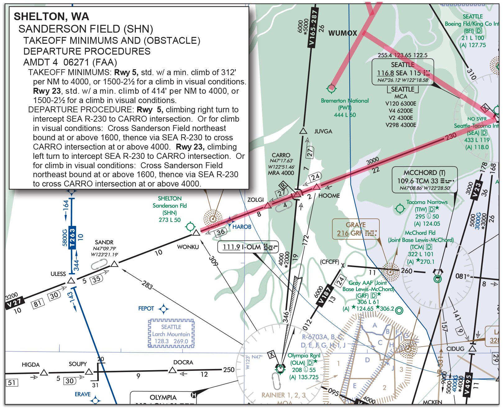
The flight starts at Sanderson Field in Shelton, WA (KSHN). The destination of Bremerton, WA (KPWT) is only 22 miles as the crow flies, but only because the crow flies VFR. The instrument route takes 83 miles of zig-zag, and therein lies the challenge. Olympia, WA (KOLM) is your alternate—which you’ll need.
It might always be sunny in Philadelphia, but the weather is always rotten in the sim. Set it for broken clouds from 600 MSL up to 5000 feet or so, and visibility one mile in rain. Thicken this brew by setting the surface winds 250 at 20 gusting 28, and winds at 4000 feet blowing 230 at 35.
You’ll depart from Sanderson’s Runway 23 following the obstacle departure procedure, which calls for a climbing left turn to intercept R-230 from the Seattle VOR (SEA) inbound to the CARRO intersection. CARRO is defined by SEA R-230 and R-346 from the Olympia VOR (OLM).
VOR users will want these frequencies and radials dialed up. Tip: You’ll also want the Bremerton ILS in standby for your primary navigator and SEA in the standby of your second nav. You’ll see why. Even if you use GPS, get those VOR frequencies set. You might need them more than you think for getting going the right way or staying on the black line while you switch up approaches.
GPS users can load the route, but think this through. Assume you filed “KSHN SEA KPWT” and you added, “Will fly the KSHN ODP” in your remarks. When you get your clearance from FSS over your cellphone, it’s simply “…cleared as filed. Maintain 5000…” So how will you set that up in the GPS? Textual ODPs like this won’t appear in the database. The ODP isn’t direct CARRO; it’s an intercept and then CARRO.
No matter what nav you use, those winds will hurl you eastward towards CARRO and your filed route. Stage your climb as you would normally and get established northeast-bound toward SEA.
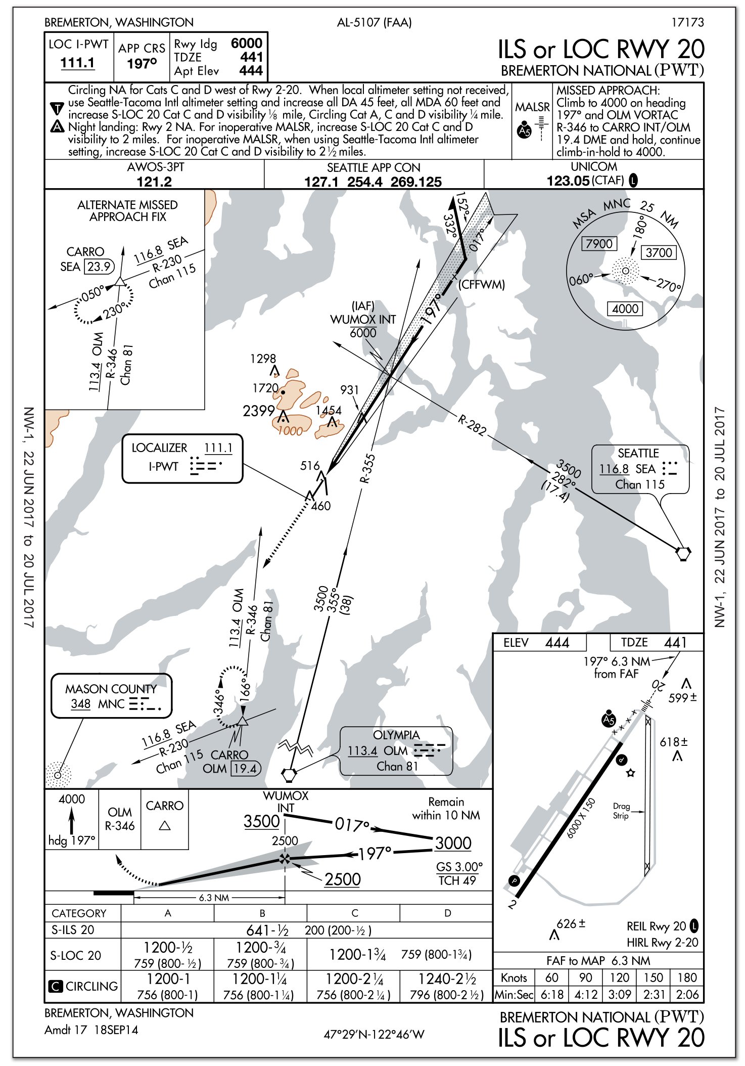
You’ll fly the ILS or LOC Rwy 20 at Bremerton via the transition from SEA to WUMOX. Joining that transition from V27 is a 128-degree turn, which is eight degrees over the TERPS limit. This chart probably should say, “Procedure NA for arrivals on V27 northeastbound,” but it doesn’t, so you’ll give it a go.
While outbound on the transition and correcting for the crosswind, get the Bremerton localizer ready, because you’ll close on it at a nearly 90-degree angle. Then it’ll be a turn outbound with a tailwind (correcting away from the needle if you don’t have an HSI). Be sure to stay within 10 miles of WUMOX as you fly the procedure turn of your choice.
After intercepting the localizer inbound, it’s a vanilla ILS. Except for the 30-degree headwind from the right, and the turbulence your sim will probably add because of the cumulus clouds. You can leave SEA active to identify WUMOX inbound and verify the crossing altitude on the glideslope of 2500 feet. But you might want to use OLM instead so that VOR is ready for the missed.
At the DA of 641 you’re still IMC, so you’ll fly the missed—starting with a dead-reckoning heading of 197. On paper this creates an intercept with R-346 from OLM. Given the quartering headwind, I’d probably track the localizer outbound, but you could let yourself drift south holding a heading. Just don’t go south of R-230 from SEA again. Watching the DME count down to OLM is helpful, too.
GPS users may have to get old school or creative here. Not all GPS navigators have elegant solutions for flying a heading to an intercept as part of a missed.
Making the Switch
Enjoy practice holding at 4000 at CARRO with a serious crosswind. While you’re doing that, bring up the ILS or LOC Rwy 17 for Olympia.
You could fly V165 south to OLM, reverse course northbound for the procedure turn. However, HOOME is just two miles from CARRO. Get yourself briefed and ready, and then transition over to HOOME as you see fit. GPS users again need some creativity, lest they lose the holding fix at CARRO when they load the approach starting from HOOME.
Cross HOOME at 4000 and consider yourself cleared for the approach. There’s some significant descending to do, but your wind-correction angle will help.
You should break out 100 feet above DA. Land, if your sim cooperates. If you try, I recommend holding a crab angle all the way into the flare and then kicking out the crosswind correction. Don’t get mad if you slide off the runway.
Or, if that doesn’t sit well with your mind, change the ceilings to 900 MSL before you fly this approach so you break out high enough to circle for Runway 26.
Questioning Yourself
Once you’ve flown it in your mind or on the screen, consider the following.
1. The ODP from Sanderson says to climb at CARRO to 4000 before continuing on course. However, the MEA for that segment of the airway is only 3000. Presuming you reach CARRO just as you cross 3000 MSL, how high must you climb before continuing toward SEA (still climbing to your cleared altitude of 5000)?
2. The ODP just requires a left turn to intercept SEA R-230 (aka V27). What heading did you use to intercept, giving the 35-knot tailwind?
3. GPS users: You probably put CARRO into your flight plan for this departure, but how did you set up your GPS to intercept R-230?
4. GPS users get turn anticipation, which simplifies the turn from SEA R-230 inbound to R-282 outbound. Technically, VOR users should overfly the VOR and then turn back, but this would be a big overshoot with the tailwind. If you decided to lead the turn without GPS, how would decide when to start?
5. Outbound from SEA to WUMOX, you’ll be crabbing into the wind, so your groundspeed will slow. Even so, you’re crossing a localizer, not a VOR radial, so there isn’t much warning as the needle comes alive. Without GPS, how can you anticipate the turn to track the localizer outbound?
6. For those of you using GPS with turn anticipation for the turn at WUMOX: Did you overshoot anyway? Why?
7. You must stay within 10 miles of WUMOX for the procedure turn. With that tailwind and without GPS, how do you know you’re within 10 miles of WUMOX?
8.On the missed at Bremerton, did you fly the localizer outbound or simply hold a heading? Why?
9.What wind correction did you use in the hold at CARRO on R-346?
10.How did you fly the transition from CARRO to HOOME? Is that what you would do with ATC available?
One thing you may have noticed about this challenge is how behind you can get crossing fix after fix in rapid succession. One additional takeaway from this might be “fix crossing discipline.” Back in the day, it was the five Ts: Timer started, Turn to the new heading, Throttle as needed, Twist the CDI to the new course, Talk to ATC or CTAF (if needed).
With RNAV it’s not quite the same. We’re still in search of the best generic substitute, but CAPERS works pretty well: Course for the new leg, Altitude for the new leg, Profile to fly (pitch, power, flaps, gear), ETA to the next fix (how much time do you have, or start a timer if you need it), Radio communication and navigation sources, and Safety/Switches (basically a flow check or GUMPS).
It’s not perfect, but it’s more generic in a world where simple tunings, twistings, and lost techniques no longer take you direct to a fix using only two VORs and a lot of faith in probability.
Debriefing Points
1. Once at CARRO and above 3000 you know there’s no obstacle issue because the MEA is 3000 feet. Because the use of an ODP is at the pilot’s discretion, it logically follows you could abandon the ODP at this point and climb along R-230 (V27) on course. That said, you included “will fly the ODP” in your remarks and were “cleared as filed.” My feeling is ATC wouldn’t care and would have the altitudes clear of conflict because they knew you were climbing. As always, though, it’s best to let them know, “We’ll be climbing on course past CARRO.”
2. Even with the tailwind, a casual intercept of 30 degrees (heading 180) should do the trick. This is math you want to do beforehand, or use the HSI to find. You’ll also want some how-goes-it if you don’t have GPS to see your position relative to CARRO. DME from SEA is a good proxy.
3. There are many ways, including OBS mode, or direct-to with a course of 230. The one I like most is adding WONKU to the flight plan before CARRO, and activating the leg from WONKU to CARRO before takeoff. That’s the leg of the airway I want to intercept. Once on it, my GPS will sequence automatically.
4. Turn radius is roughly your speed in NM/min squared divided by 10. For 120 knots, that’s 2^2/10 or 0.4 miles. Without drawing fancy diagrams, a 90-degree turn with no wind would require starting the turn a distance from the VOR equal to your turn radius. A 135-degree turn is more like 2.5 times your turn radius. Starting a turn about a mile before the VOR will be close. You’ll have to adjust as you go because your groundspeed will change through the turn.
5. The best methods are DME from SEA or R-355 from OLM. The disadvantage of the latter is that it’s probably the same nav you’ll use outbound on the localizer, so you’ll need to switch frequencies, re-identify the localizer, and turn. Juggling which frequency displays on which CDI is part of the secret to this sim challenge.
6. GPS uses groundspeed to predict turn radius. Unless it has hooks into your actual heading and indicated airspeed however, it has no idea your groundspeed will increase when you turn downwind, messing up the turn anticipation. Fully integrated systems like the G1000 have an advantage here.
7. Unfortunately, you can tell there’s no DME off the Bremerton localizer because there’s no DME channel listed in the frequency box. DME is paired automatically for GA pilots, but the presence of a channel number tells you if it exists at all. Without GPS, you could use DME from OLM as a rough proxy, or a radial from SEA. One degree off course is one mile at 60 miles from the VOR, so at 20 miles it’s (roughly) 0.3 miles. Therefore, 10 degrees is about 3 miles, and 33 degrees is about 10 miles. Dial in R-315 from SEA and don’t cross it. Not perfect, but pretty close.
8. Flying a heading is simpler and it’ll drift you in the right direction. There’s enough slop in the TERPS criteria to allow for this. That said, all RNAV approaches have you fly a track over the ground, and most modern GPSs will do exactly that. Personally, I like a “heading” that keeps me on course, unless it’s an ATC vector.
9. I like three times the inbound correction on the outbound leg when the wind is blowing me into the inbound course. Better to over correct at first than overshoot turning inbound. You should have plenty of time to perfect an inbound correction to track towards CARRO as you transition from the missed.
10. You could cross CARRO, turn hard left up V26, then hard right to not overshoot HOOME. But why? My plan would be loading a fresh approach in the GPS while heading outbound in the hold (when I’m just flying a heading for a minute or so). Without GPS, this is when I’d tune the Olympia localizer. When I turn inbound I’d request direct HOOME and clearance for the approach. Since airways are four miles of protected airspace either side of an airway, side stepping to direct HOOME only two miles east of CARRO will be obstacle free. Don’t forget you’ll need some way to tell how far outbound to go before the turn inbound and direct HOOME.
Jeff Van West sometimes misses the days of tracking an NDB in a crosswind gale at night to minimums. Then he ruminates on the matter, looks at his GPS navigator and iPad, and thinks: “Nah …”


