
While some readers probably welcome a refresher on turbulence, shear, and thunderstorm dangers, others might see it as beating a dead horse. But Wx Smarts is that intersection between my 30 years of forecasting and your thousands of hours of instrument time. Within these articles I guarantee there’s always something that wasn’t fully covered in flight school or the FAA circulars. Whether it’s more detail or just an unusual situation, the goal is to keep you interested, thinking outside the box, and having more insight into aviation meteorology than the average pilot.
A few times a year, we explore aviation accidents, going from the theoretical to the practical and drawing from the NTSB’s rich archives of accidents, error, and tragedy—specifically the meteorological ones. Let’s take a break from low ceilings, fog, and ice and look at some common late-summer and autumn trouble areas. Most of these involve thunderstorms and wind shear.
Instability Meets Shear
In November 2016, New Jersey news stations reported the crash of an airplane in a wooded area in New Gretna, New Jersey, about 20 miles north of Atlantic City. The victim was the 75-year-old pilot and sole occupant, who had 800 hours under his belt. He was flying a Ryan Navion, a 1948 North American Aviation single-engine piston aircraft designed for the Reserve Officers Training Corps program.
An active weather system had been moving through the area. Although a friend of the pilot reported passing weather information on to him earlier in the day, official records showed that the pilot did not obtain a formal weather briefing. The pilot spent the day in Virginia. After dinner with a friend, he departed for the 200-mile return to Toms River, NJ, about 1730 local, near sunset.
While the pilot enjoyed a serene Saturday evening at 5000 feet, weather trouble was brewing on the western horizon. The nearest major city west of the pilot’s destination, Philadelphia, had been enjoying a sunny afternoon with light winds and temperatures near 70 degrees F, but these temperatures fell into the 50s with winds gusting to 39 knots as our Navion pilot crossed eastern Maryland with an hour to go.
At 1824 local, the Millville, NJ ASOS station, 40 miles away at the pilot’s 10-o’ clock, reported winds increasing rapidly from 230 degrees at nine knots to 290 at 23 gusting to 33 knots, followed by a 41-knot gust within the hour. Sudden gusty conditions were reported at nearby Atlantic City and Dover AFB as this front passed. The National Weather Service issued a high-winds advisory for this front, and state authorities reduced the speed limit to 45 mph for bridges crossing the Delaware River.
The Navion pilot flew most of his route home at 4500 to 5000 feet, but the first sign that something was amiss came at 1849, when FAA radar showed a sudden turn to the northwest. The pilot then began an erratic path that aimed northeast again, gradually descending to 1000 feet and completing three random left turns and two right turns. During these turns his altitude varied between 200 and 2100 feet MSL. The plane finally impacted the ground a few miles southwest of the Warren Grove Gunnery Range at 1903 local.
The pilot’s cell phone records were used to locate the airplane. A U.S. Coast Guard aircraft located the wreckage the next afternoon in Bass River State Forest and the investigation was turned over to the NTSB.
What Went Wrong?
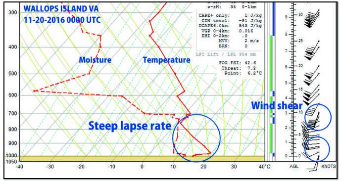
While we can only speculate what happened in the last few minutes, it’s clear that the pilot was precariously short on airspeed and altitude strongly suggesting that the airplane was not fully in control. Earlier during the flight, a call for a weather briefing would have revealed an AIRMET for moderate turbulence and sustained surface winds over 30 knots. Not only was there no weather briefing, the pilot was also relying on a Garmin GPS to navigate and had no active weather subscriptions.
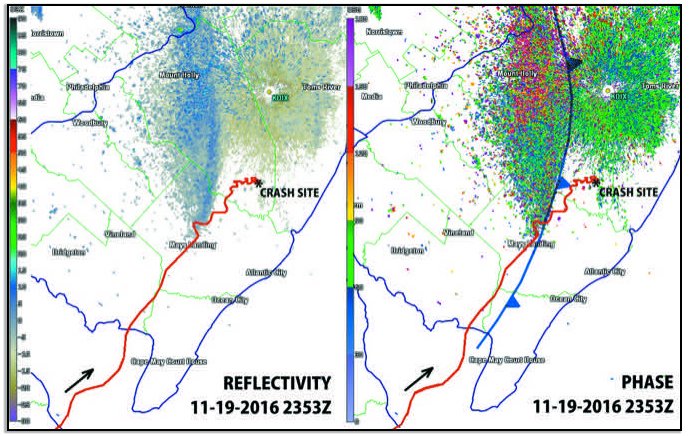
Weather radar showed an intriguing picture (opposite page). Even the most powerful weather radar data available, the WSR-88D site at Fort Dix, 25 miles away, pumping out almost a megawatt of power, detected no thunderstorms, no cells, and barely detected a broad zone of weak 10-dBZ echoes. Tablet or MFD-based radar displays that are optimized for heavier precipitation may not have shown anything, perhaps treating this as clutter, and airborne radar with its weaker power and shorter wavelengths would definitely not have picked up anything of interest.
However advanced products not normally available to pilots—velocity, and in particular spectrum width and phase—clearly reveals a strong front approaching. These are products that forecasters are trained to use, and it highlights that sometimes danger is indicated even though reflectivity is giving the “all clear.”
The Frontal Zone: No Joke
Looking at the radar plot and the airplane’s path, you might find it curious that the airplane was behind the front but got into worse trouble once it got out ahead of the front, where we would expect lighter winds. Keep in mind that friction is strongest close to the ground and weaker aloft. The front is able to easily advance eastward hundreds of feet above the ground, and vigorous mixing helps bring cold air to the surface while bringing warmer air to higher altitudes. The result is a broad zone of formidable mixing along the frontal boundary, with strong turbulence and the potential for strong wind shear. Vertical velocities can exceed 1500 fpm.
There was no shortage of PIREPs indicating problems. The most troublesome ones were from the Philadelphia area, 40 miles northwest of the crash site an hour before it occurred, indicating severe turbulence: two different ERJ-170s reported moderate-to-severe turbulence northwest and southeast of Philadelphia International Airport, the latter report just 11 miles from where the Navion pilot’s first major deviation took place half an hour earlier.
A radio call to Washington Center might have made all the difference. Tablets and other devices can create “information overload,” particularly with fragmented data like PIREPs and cluttering of multiple reports around terminal airspace. Briefers are in a much better position to sift through the reports for what’s important. Use your cockpit resource management and delegate those difficult tasks to those who can give you better information.
We find ourselves going back to the basics. The FAA’s Advisory Circular on Aviation Weather warns us, “Frontal boundaries provide an environment favorable for wind shear conditions and turbulence due to an inherent change in either wind speed or wind direction or both.” This is a critical warning.
Simply checking the charts for fronts and wind shifts and keeping tabs on their positions is a start, but isn’t enough to keep you out of trouble. This information is available from aviationweather.gov. Choose Forecasts, and Prog Charts to get the official NOAA front positions.
Florida Fury, Titusville Thunder
Next we look at a twin-engine Cessna 310, whose short hop from Orlando to Titusville, Florida in August 2015 ended in tragedy. The 59-year-old pilot was an accomplished U.S. Navy reservist and a successful entrepreneur. He held a commercial certificate with instrument rating, and nearly 1000 hours total time—but none in the previous six months.
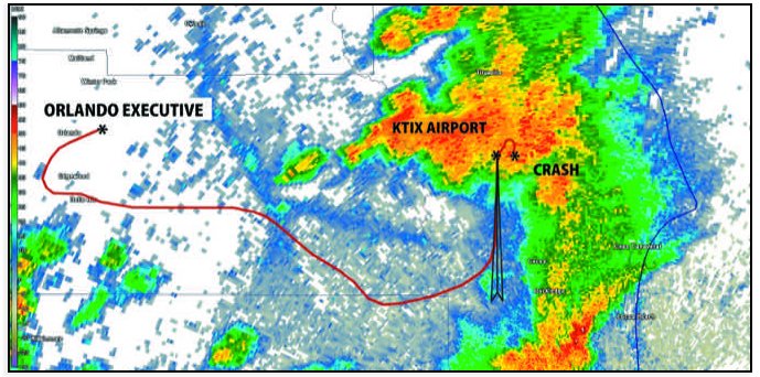
When the airplane taxied out and took off at 1555 local, large thunderstorms were brewing to the east. The TRACON controller opted to take things slow and easy, advising the pilot, “Heavy precipitation right on top of Space Coast Executive…what I am going to do is set you up for the final for Runway 9 at Space Coast and take you out to the west…then eastbound towards Space Coast, then hopefully by the time you get there the precipitation will have moved off the top of the airport.”
The TRACON controller gradually maneuvered the Cessna east towards the Titusville Runway 36 localizer, which was in the clear but led into a thunderstorm over the airport. The approach was boxed in, and the controller explained that there was heavy precipitation past 8 miles, recommending a 6 to 7 mile intercept for the ILS. The pilot said, “OK that sounds good. I do appreciate it.” At 1613 local TRACON cleared the plane for the ILS, and the plane joined the localizer on a 4.4-mile final.
Tower reported the field was IFR. The pilot said he was still IMC. The tower cleared him to land, reporting a wind of 360 at 13 knots.
Three minutes later, the pilot radioed that he was on the missed approach. The tower advised the pilot to fly the published approach and contact TRACON.
The pilot began a right turn, contrary to the published left turn, and told the puzzled TRACON controller that the weather was less severe to his right. He added, “I would like a turn to the south because this is pretty heavy.” The controller gave him a 210-degree heading. After acknowledging the heading there was no further contact from the pilot.
The airplane crashed at 1616 local just east of the airfield, near the end of its right turn to 210 degrees.
What Happened
Searchers located the airplane in six feet of water off the shoreline. Unfortunately the plane was in numerous pieces and only about half could be recovered because of currents and difficulty working in the brackish water. However it was clear to investigators that the plane hit the water with significant energy and appeared to have been in sound mechanical condition.
The pilot called 1-800-WXBRIEF hours before his departure, concerned about the thunderstorm conditions. The briefer informed him his route was under a convective SIGMET. The pilot reported he had weather radar and XM Satellite equipment and he was aware of the latency issues associated with the system. The briefer recommended contacting them later for an update, of which there is no record.
An NTSB investigation found that the TRACON controller cleared the pilot for the approach but did not offer updated weather, nor did the pilot ask for it. ATC radar indicated a thunderstorm directly over the airfield, but no coordination was made with the Titusville tower to check on the conditions, which were still published as VFR.
The tower controller said the tower was struck by lightning at 1605 local, five minutes after assuming his duties. The strike knocked out the radar, caused sparks in the panels, and knocked out the voice circuit to Central Florida TRACON. The chaos preempted the pending special weather update of IFR conditions, and the two tower controllers were swamped. The supervisor was surprised to hear the Cessna on approach.
Radar logs found that after executing the missed approach, the airplane proceeded with a climbing right turn then suddenly entered a rapid descent. This is consistent with loss of control in wind shear or a microburst. A review of detailed Level II WSR-88D radar data found that not only was a thunderstorm over the airfield but that it exhibited downburst signatures. Storm tops were over 50,000 feet and two small, intense downdraft cores blanketed the airfield only 15,000 feet above the ground. Cross sections showed the development of a “rain foot” caused by rain and cool air reaching the ground and spreading horizontally.
The storm also showed an outflow boundary moving southward at 20 to 25 knots, along with intense motion in higher parts of the storm. At 12,000 feet above the airfield, radar detected northbound velocities over 51 knots, thought to be part of the inflow conveyor belt feeding the cumulonimbus towers from the south. Clearly there was more going on in the cloud than anyone suspected, and a chain of oversights, errors, and tenacity led to the accident.
What Can We Learn?
I normally prefer to just lay out the facts and leave it to the newspapers, the NTSB, and attorneys to find fault. But what are the lessons learned here? It’s reasonably safe to conclude that the pilots in this article didn’t have ultimate control of their aircraft in the last moments, with many lost opportunities to turn back. It’s the capacity to rapidly identify all the signs and information about a bad situation in those last few minutes that separates accident victims from those who made a last-minute choice that saved their lives.
Don’t just take the information handed to you. Talk to the controllers and ask questions. Seek out PIREPs (and provide them too). Trust your gut instinct. And more importantly, don’t let yourself get boxed in—always have an out and stay safe out there.
Meteorologist Tim Vasquez briefed B-1B crews in the morning. Now he sleeps in and writes books and software. See www.weathergraphics.com.


