Uncontrolled Anarchy
I have for some years read your columns in IFR and have enjoyed them. You (and others) have regularly differentiated between “controlled” and “uncontrolled” airports. I suggest that it would do all of us some good to change the references to “FAA controlled” and “pilot controlled” airports.
Mark M Anderson
Sarasota, FL
Actually there is FAA guidance on this. The term “uncontrolled airport” implies aviation anarchy to the uninitiated and is therefore no longer politically correct. In the true spirit of spin control, airports are either tower or non-tower by current FAA definition. This gets around the unruly implication carried by the word “uncontrolled.”
Is Special VFR Also VFR?
I have a question concerning your editorial response to the letter headed “VFR Only” in the March 2016 edition of IFR. I fly a Robinson 44, which is marked in the Restrictions section of the POH as “VFR only.” So flight on an IFR flight plan, even in perfect VMC, is not legal.
But I take issue with your remarks about SVFR. You imply that SVFR is not VFR. The name clearly suggests otherwise, and 91.157, which describes SVFR, is in the section header “Visual Flight Rules.” I can find no indication there or elsewhere that flight under SVFR is not also flight under VFR.
Can you substantiate this assertion?
John Harper
Mountain View, CA
Nope, I can’t substantiate it. I’ve since taken another look at this and have changed my mind. I was wrong.
While the TC and the POH both tell us the aircraft is approved for VFR only, I’m forced to agree that SVFR is part of what qualifies as VFR.
I still maintain, though, that SVFR is an edge case and, as such, deserves an extra level of caution in an aircraft that can’t be flown legally below VFR, be it “basic” or “special.” —FB
Long Runways Only?
I just reviewed Garmin’s service advisory 1604, and it sure sounds like they’ve dropped airports that don’t have a runway longer than 4000 feet.
Uh, whassup? I often fly to an airport that has a nice RNAV approach to a runway measuring 3800 feet. Will that approach or (gasp!) airport disappear?
Sal Cruz
Watsonville, CA
We spoke with Garmin’s Aviation Media Relations specialist, Jessica Koss. While the report is true, it’s not quite the “sky is falling” scenario that one might think.
Dropping airports with shorter runways began with database cycle 1602 (4 February 2016), but it applies only to the Worldwide Navigation Database. So, if you have a regional database—North America, for instance—your database is unaffected. Cowpatch Muni with its 3500-foot runways is still there.
Their reasoning is simple and logical: One database with all the airports, data and approaches in the world is rather large and growing. It’s exceeding the database size limits in some Garmin navigation systems. Chances are, though, that if your aircraft has need for airports in Argentina, Norway and New Zealand, you’re probably not going to be utilizing those shorter runways anyway. Those who are affected probably don’t care.
But if you do care, you’ll have to load the individual regional databases separately, as needed.
But I Wanna Go Straight In
Naples, FL (KAPF) has RNAV A and RNAV B approaches. Both approaches line up within a few degrees of Runways 32 and 14 respectively. However, only circling minimums are published.
Why aren’t these approaches straight in to their respective runways since the inbound courses align so closely with the runway headings?
I have been flying for 44 years and have subscribed to IFR for at least 15 of those years. Your publication remains my favorite read each month. Please keep up the good work.
Paul Cook
Houston, TX
Please see the article “IFR Airport Basics” in the January 2016 issue for a full explanation.
Yes, at Naples, the approaches are suitably aligned with a reasonable descent gradient to the runway for straight-in minimums. However, the runway just has VFR markings, not instrument markings. This prevents straight-in minimums (with some exceptions).
Don’t confuse minimums with procedures, though. Even with circling minimums, it’s permitted to land straight in, so long as you can do so meeting the requirements of 91.175 (normal maneuvers, flight visibility, paint/pavement/lights).
Thanks for the kind words, Paul.
In “IFR Airport Basics” in January 2016, you explain the lack of runway markings requiring circling-only minimums at KCQX. We have a similar situation at Palm Beach County Airport, FL (KLNA). We initially thought it was due to high MDAs, but this was inconsistent with many other GPS approaches that are straight in. So the explanation in the article—lack of instrument runway markings— makes sense.
But now look at the GPS approaches to Runways 24 and 6 at Pompano Beach, FL (KPMP). These are straight in but the runway doesn’t have instrument markings. So what gives?
Maybe the approach type (LPV vs. LNAV) or the requirement for WAAS makes the difference?
Luca Bencini-Tibo
Weston, FL
That’s a good question, Luca. In the past, this instrument-marking requirement wasn’t strictly enforced, and you’d occasionally find straight-in procedures to runways with only basic VFR markings, as is the case at KPMP. Neither the approach type nor WAAS is a factor.
Note that the KPMP approaches date from 2007 and have only received abbreviated amendments since then. The FAA has started to enforce this runway-marking requirement during periodic reviews, so it’s likely that the next time the KPMP procedures receive a full amendment (amendment 2 for both of them), there will be instrument markings on the runway (or at least a plan for them), or the procedures will change.
By the way, this is the case in the lower 48. This requirement—and many others—remains much looser in Alaska.
How High and By Where?
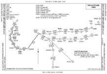
Reading your explanation of the TERPZ FIVE DEPARTURE at BWI, which was in response to a question regarding altitude restrictions and expectations, I am not convinced that the procedure as published is clear.
The issue I see is that, regarding the specific runway instructions, each one ends with “to cross TERPZ at or above 11000, thence…” This looks to be in conflict with the top altitude as published on the graphic.
My interpretation would be that the assigned transition begins at TERPZ. No doubt TRACON handles this in a routine fashion so as to eliminate confusion, but it looks to be a problem in the event of lost com. I think I would maintain the 4000 until 10 minutes after departure, but that’s in direct conflict with the text which says to cross TERPZ at or above 11,000. What do you think?
Frank R. Loeffler, Jr.
Cornish, NH
You were cleared via the TERPZ FIVE. The TERPZ FIVE has altitude/crossing restrictions, so those are part of your clearance. Yes, you start with a climb to 4000 feet, but then you’re required to cross TERPZ at 11,000. So, you initially climb to and cross WONCE at 4000 feet. Then you climb to cross TERPZ at 11,000 feet. After 10 minutes, you can climb to your filed altitude. All this assumes lost com, of course.
We read ‘em all and try to answer most e-mail, but it can take a month or more. Please be sure to include your full name and location. Contact us at [email protected].


