
From time to time we look at weather accidents, reviewing the factors that might have led to poor decision making or perhaps even weather that could not be anticipated. In this edition we’ll take a look at the crash of a Pitts biplane in IMC conditions in California, and a Beechcraft Baron that went down in bad weather in Kentucky. Both of these incidents took place in April, so they should give you some food for thought this time of year.
Springtime in Lebec
We bring you first the puzzling case of a biplane, a Robert C. Hanson Pitts S2E, that departed Bakersfield in VFR conditions but flew through a mountain pass, allowing the weather to close in around it. What is noteworthy is it was flown by an experienced airline pilot, age 36 with 8200 flight hours and type ratings in the A320, Beechjet BE-400, Hawker HS-125, and a few other business jets. Two weeks before the accident, the pilot had received an endorsement in an S2E that covered most important procedures.
The pilot was ferrying the aircraft from Bakersfield, California to Missouri via Blythe, California. The track would take the pilot southeast through the Tejon Pass and out into the Mojave Desert. The terrain would rise from 300 feet to a minimum of 4160 feet in the pass, then drop to 2300 feet in the desert.
About 15 minutes after departing Bakersfield, 40 miles away, witnesses observed the biplane approaching Tejon Pass. The witnesses said the plane was 50 feet above the ground proceeding “extremely fast in a southeasterly direction,” and that there were dense low clouds. A second witness working on Tejon Ranch reported the weather on the morning of the crash was “ugly,” with a front moving through the area, and that it was drizzling and rainy with low, dark clouds. Cowboys who were herding cattle had to stop work because the visibility was too low.
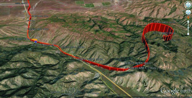
The aircraft was found the next day by a ranch worker in a rugged high canyon, about three miles northeast of the town of Lebec and four miles from the freeway at an altitude of 4000 feet MSL. Rescuers needed 4-wheel vehicles to reach it.
The pilot had a Garmin GPSMAP 396. A forensic data recovery by the NTSB was successful in reading the unit, and found that the aircraft had followed Interstate 5 southward at 200 feet AGL to less than 100 feet, then departed the freeway and began a wandering climb eastward, reaching an altitude of just under 6000 feet, suggesting a sudden decision to seek out clear air or reach for the tops.
The plane then suddenly entered a very tight right turn and lost altitude, crashing at the 4600-foot level. These last seconds suggested the pilot became disoriented and stalled, possibly with misleading horizon cues. The NTSB investigation cited the cause as continued visual flight into instrument meteorological conditions, which resulted in failure to maintain sufficient terrain clearance.
A drug screen on the pilot did not find any indication that he was impaired.
A Rundown of the Weather
At the time the aircraft departed, the 1126Z Bakersfield TAF was “P6SM SKC” for the entire period. The TAF was not amended until 1445Z. Investigators put the takeoff time at 1448Z and the crash time at 1511Z, which suggest that the pilot might have been lulled into a false sense of security. However the AIRMET issued three hours earlier called for BKN010-015 TOP 030 with fog and haze. There was no record of the pilot obtaining a briefing.
This underscores the need to be aware of terrain effects and weather between stations. The Bakersfield METAR at takeoff time showed BKN031 OVC038, with a temperature and dewpoint of 12/06 and winds out of 310 at 8 knots. This placed the IMC overcast at a minimum of 3600 feet MSL, much lower than the 4200-foot mountain pass. The temperature-dewpoint spread was close to the five degrees needed for significant low-level clouds.
This pattern is commonly associated with a strong Pacific cold front in California. The winds blowing down the valley toward the southeast and the strong westerly winds in the Mojave Desert are classic indicators. Dust can sometimes be picked up in the deserts. These winds create large regions of upslope clouds at the southeastern edge of the valley.
Upslope flow can easily be one of the biggest contributors to IMC. Sandberg, about 10 miles away in the mountains at 4500 feet MSL, reported 34025G35KT 1SM BR OVC002, underscoring the very low ceilings and visibility.
Winds were 270/35G45 at Mojave, close to Tehachapi Pass, indicating not only low-level wind shear hazards but the potential for strong coupling of the wind field across the pass. The strong downslope winds with clear conditions in the Mojave Desert can be taken as a good sign of strong upslope winds and continued poor conditions on the slopes east and south of Bakersfield.
We will never find out why the pilot opted not to fly over the top of the clouds, although one might speculate it was concern about mountain waves or sheer altitude. A quick analysis of infrared imagery showed these clouds probably reached 12,000 feet MSL.
The pilot presumably decided to follow Interstate 5 with the intention of turning back if things got too difficult, and it appears he quickly found himself out of his depth. Tejon Pass is flanked by 1000-foot AGL peaks with 45-degree slopes. I’ll leave that for the reader to ponder. However the fact that the flight into the pass was flown at 125 knots, far above the 54-knot stall speed, leaves no margin for maneuvering among fog-shrouded peaks and raises many questions about what the pilot’s plan was.
Little needs to be said from the information laid out here. This column could simply make a case of the sins of overconfidence and bad judgement; however my job here is to find things that help. Two things stand out: First is the need to be fully prepared for the possibility of weather away from METAR and TAFs sites to be far worse than the neighboring sites are indicating, and second, always consider the role of terrain interaction.
Here, the simple knowledge that the air mass is somewhat humid and an upslope-downslope flow regime occurs across a mountain pass should raise concern that the passes may in fact be solidly socked in. Even on the Great Plains, east-to-west flow with humidity of 80 percent or higher is often sufficient to bring ceilings down to IMC across vast areas. And with the ceiling above the airfield much lower than the passes, it is clear that what the pilot did was inadvisable.
In an area like mountains and passes, the upslope effects are multiplied due to the steeper terrain and higher vertical velocities. On a day like this, the passes would clearly be shut down until the northwesterly flow subsided or the air mass dried out. Indeed, the Sandberg automated site didn’t see a break in instrument conditions until 5 p.m.
Downed Beech in Kentucky
Next is a Baron 58 that was en route from Frederick, Maryland to Olive Branch, Mississippi. The pilot was 68 years old with 1545 hours total time. He held commercial and instrument ratings but only 14 hours of instrument time. A 59-year old female passenger accompanied him. Both were active in the equestrian community and lived in Maryland.
The pilot planned his route for 9000 feet, and around 9 a.m. he called 1-800-WX-BRIEF. The briefer identified a convective SIGMET for thunderstorms in Kentucky, then discussed the IMC area, and covered the moderate turbulence areas over the Appalachians. She then discussed the icing: moderate ice from the freezing level, at about 6000 to 18,000. Much of the rest of the call was focused on the return flight as well as the tops of the weather system, with the briefer looking for PIREPs to gauge the vertical extent of the weather system.
Takeoff at 10:24 a.m. EDT was uneventful but the flight began entering IMC. Shortly after crossing into Kentucky, the pilot inexplicably climbed to 12,000 feet. Talking with Indianapolis Center, he reported problems with the airspeed indicator and requested a lower altitude.
“Uhh, Baron [call sign], requesting lower, losing airspeed.”
The controller replied. “Descend and maintain 5000 and that, uh, my reports at 5000, actually, once you get through 7000 if there’s any icing it should be gone but just let me know if you can maintain level flight once you get there.”
“[Callsign], wilco.” After about half a minute the pilot called again. “Just went down like an absolute rock! I don’t know what happened, we’re level at–” No further transmission was heard.
The controller then tried to raise the pilot but with no reply. A Cessna 421 in the area offered to act as a relay, and spent three minutes trying to contact the pilot but without any luck either.
The plane was found a few hours later in a mountainous maple-oak forest about three miles northeast of Bear Branch, Kentucky near the top of low mountain peaks that extended to near 2000 feet MSL. Investigators found the airplane was equipped with a supplemental type certificate de-ice boot system on the leading edge of the wings and vertical stabilizers. All of the boots were found in an inflated state.
Analysis
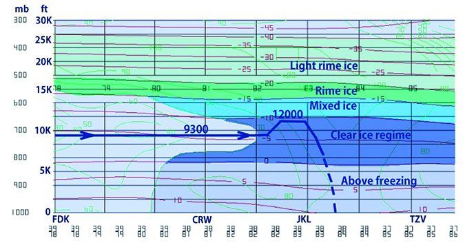
We hardly even have to look at centralized guidance to see the flying challenge this day presented. A large area of precipitation covering much of Kentucky with extensive solid 35-45 dBZ echoes was associated with a slowly moving cold front. This precipitation in turn was caused by isentropic ascent, or overrunning, mostly caused by a combination of cold air advection displacing potential temperature surfaces upward, augmented by upper-level lift. The freezing level was located at 6000 feet. However this was a very deep weather system with stratiform tops extending to 30,000 feet.
In Kentucky we had all the necessary ingredients for significant icing: an extensive region of near-saturated air, cloud temperatures between 0 and -15 degrees C, and sources of lift. This was a quite potent clear icing setup. However with this being a springtime event, temperatures near the ground were a warm 45 degrees F.
We have the benefit of a cross section along the route that comes from a detailed NOAA numerical model reanalysis with 32 km resolution. This confirms the airplane was heading directly into a region of strong clear icing, with mixed icing likely as high as 14,000 feet.
It should be said that you don’t need to be a computer whiz to have access to this data. The ADDS Flight Path Tool is available online at aviationweather.gov. It allows a vertical cross section to be set up along your flight route, and you can plot everything from temperature and relative humidity to icing.
As I am a meteorologist by trade I can tell you that visualization, building a 4-D mental picture, is 75 percent of a good forecast. I recommend to pilots that the ADDS Flight Path Tool is a website to visit often. Visualization is not just a technological feat; it’s something that happens in the brain by putting together the proper charts and data sources, and the Flight Path Tool does all the hard work for you.
From my perspective it appears that the pilot did not have a proper visualization of the icing conditions. Given the circumstances, the climb to a higher level seems puzzling as clear ice would have reached possibly as far as 14,000 feet at -15 degrees C.
It appears possible the briefer could have stressed the icing impacts harder, but there was plenty to cover, and the pilot has the responsibility of double checking everything and applying what was learned during the briefing. It’s possible that the pilot was overwhelmed by everything covered in the weather briefings—icing, turbulence, IFR, destination TAF, etc.—and was blinded by thedominantweather hazards of low ceilings and instrument conditions, rather than the area’ssignificanthazard, icing.
Flying the route just below the freezing level, if the MEAs across the Appalachians allowed it, or at least opting to dogleg around the activity or delay the flight would have been sensible precautions. The radar charts showed much weaker precipitation 150 miles to the southeast: away from the front and away from the upper-level lift. Had the pilot chosen one of these alternatives, we might well be covering a different accident. The NTSB cited an improper in-flight planning/decision, continued flight into adverse weather (icing conditions), and failure to maintain an adequate airspeed during the emergency descent.
Lessons to Learn
As you can see there is a common theme here: having all the information before you but opting to disregard it or being absorbed by other concerns. This can quickly get you in trouble. It’s always best to start with the big picture. If you view the forecast maps and satellite imagery and can see that it’s clear blue and VFR, you’re probably in good shape. But with a front between you and your destination, it’s important to take a closer look and make sure the forecast data agrees with your briefing and the TAF information.
Always return to the basics and weigh what you see with the lessons you learned in ground school and refresher training. The discrepancies and inconsistencies you will encounter should not be considered annoyances or errors, but vital clues alerting you to sudden changes in the forecast or unexpected hazards.
With that, we’ll be back for another discussion about aviation weather next month. Stay safe!


