
Cruising along under IFR, there’s an MOA or restricted airspace ahead. On FIS-B, you pull up a page that shows its size and status: Scheduled in green, activated in yellow, red if in use. The display is as dynamic as visual TFRs that come and go.
Transparent real-time access is helpful during flight planning and while airborne. Transparency increases safety, fosters efficient traffic flow, and helps us fly shorter routes.
Background
While that’s not here, it is in the works. Section 1085 of the National Defense Authorization Act, which took effect on January 1, 2021, explicitly lays the implementation mandate on the FAA and the Department of Defense.
The timing is good. In 2020 a memorandum of understanding between the FAA and DoD focused on specific joint efforts toward modernizing the National Airspace System, the NAS. As a Marine general recently noted, “We are currently experiencing the most collaborative and cooperative environment between the FAA and DoD in many years.” Moreover, meeting Section 1085 has the highest visibility and support within both organizations.
The task is proving far more complex than the legislation envisioned. To scope out the problems and formulaic solutions, the government did what it often does: they formed a committee. The FAA’s “Tiger Team” consists of FAA and DoD experts charged with finding solutions.
Yet, the Tiger Team’s output is half the total solution. Avionics vendors will need to build products to display and use that information on our flight decks and elsewhere.
Our national security depends on our military’s special use airspace to train as they fight: aircrews fly, practice aerial gunnery, fire missiles, and so on. Ground maneuvers include firing live artillery. The invocation of special use airspace, SUA, will not decrease.
That said, the military is legally obligated to use only the airspace it needs only for so long as it needs it. By federal law (49 USC 40103), each citizen of the United States has a public right of transit through navigable airspace. MOAs and Restricted airspace are often split into subsectors for that reason. The military has formal regulations that detail how to do this in practice.
SUA Defined
SUA is airspace with defined dimensions wherein activities must be confined because of their nature, and limitations can be imposed on aircraft that are not part of those activities.
SUA’s primary purpose is to establish and define airspace to support the military’s national defense and security mission requirements. The FAA might create restricted airspace that confines hazardous activities like gunnery, non-eye safe lasers, unlit balloon tethers, or MOAs to segregate non-hazardous activities from other airspace users.
Charted SUA identifies where military activities occur to support existing or known future military airspace requirements. SUA is not established without reason.
In most cases, the controlling agency is the ATC facility that controls the airspace when the SUA is inactive. A military ATC facility can be the controlling agency if the FAA agrees. The using agency is the military or other organization for which the SUA was created. They set the schedule and inform the controlling agency of all changes.
Charted and uncharted temporary SUA is published in the Federal Register and at sua.faa.gov. Special military operations and temporary MOAs post at www.faa.gov/air_traffic/publications/domesticnotices. TIS-B shows graphic and textual products for temporary MOAs and temporary Restricted areas.
Participants are aviation or ground-based users. Nonparticipants are all other airspace users like us. IFR aircraft are normally routed around SUA. ATC must separate nonparticipants from SUA by at least three nautical miles and 500 feet vertically per the Controller’s Handbook, 9-3-2.
By letter of agreement, the controlling agency may route IFR aircraft through active SUA if it’s safe. VFR aircraft may fly through an active MOA with or without flight following. MOAs terminate at the base of Class A airspace but can be extended higher using ATC Assigned Altitudes (ATCAAs). Not all, but most ATCAAs are disseminated. Restricted airspace may extend into the flight levels. Nonparticipants are never allowed into an active Restricted area.
Scheduled times bracket the published times of use by a using agency. The SUA is activated once the controlling agency releases it to the using agency. Utilization time is when participants occupy the SUA. It is these three states the real-time display seeks to show.
Problems, Problems
Each service submits its airspace requirements for the next 24 hours to the FAA through an application tailored to its needs. The Air Force system is CSE; the Navy uses DCAST, and the Army and Marines use RFMSS. All funnel into an FAA system called MADE/SAMS, which consolidates them and shares the result with ATC and the public via sua.faa.gov, which offers text and static graphic depictions. Part of the design objective is to convert the graphics to offer real-time status updates.
Here lies the core problem. Scheduled times are published, but there is presently no system to deliver activation or utilization times even though they exist in various ATC systems. Accordingly, the FAA must develop new software to acquire and ensure accurate data delivery. It helps a little that activations typically correspond to scheduled times.
ATC will know if a scheduled SUA segment is not activated, but we might not, forcing us to fly around it pointlessly. Gaps in activity can permit nonparticipating VFR aircraft to safely transition an MOA if coordinated with ATC. VFR aircraft can transit certain types of SUA while receiving VFR flight following.
Controllers generally don’t care if aircraft are in the SUA. They just want to know whether it’s active or inactive. Then they can plan traffic patterns and coordination.
Early on, the team considered putting SUA information on the NOTAM system. The immediate problem is that SUA NOTAMs are not currently generated. Second, the system posts about 1500 NOTAMs per day. Considering the Air Force alone has well over 400 pieces of airspace that go active and inactive daily, the additional cumulative load would crash the system.
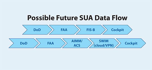
The FIS-B Solution
The Tigers are looking at FIS-B. A ground radio station uplinks a set of periodically updated data products with a specified look-ahead range over the 978 MHz UAT link. An ADS-B UAT-equipped aircraft can receive weather, aeronautical conditions, and NAS status information in its area.

The FAA estimates that about 110,000 aircraft can receive FIS-B data. Today, SUA schedules are drawn from the Special Use Airspace Management System (SAMS). Text-form FIS-B SUA messages refresh every ten minutes. A typical FIS-B text SUA message is displayed for an MOA report along with its field and description names. It’s not particularly user friendly.
When initially deployed, the SUA status look-ahead range varied from 250 NM for low altitude cellular transceivers to 375 NM for mid-altitude units and 500 NM for high altitude radios. Today all three tiers are set to a not-very-useful five-NM look-ahead due to a known system bug.
The FIS-B avionics SUA status requirements conform to a Minimum Operational Performance Standard (MOPS) published by RTCA, a nonprofit aviation standards organization. The MOPS requires that certified avionics exclude the glitchy SUA product from use.
The hangup is that inconsistencies were noted between the published SUA active hours and SUA NOTAMs regarding status outside active hours. Hence the FIS-B SUA product is unofficial. Certified avionics systems do not process or display the SUA status product. Instead, SUA NOTAMs are processed by these systems. According to the FAA, non-certified systems like ForeFlight use available FIS-B information to display SUA status information.
As for potential FIS-B changes that could support the law’s objective, the FAA is looking at near- and long-term solutions. In months the FAA could provide accurate status and schedule information. Then they could restore the look-ahead ranges to those deployed initially. Some non-certified systems could process this information without change.
The FAA could provide a graphical SUA status product for FIS-B in about two years, requiring changes to approximately 600 ground-based radios. The RTCA would amend MOPS to remove the prohibition on SUA status information and add the graphical SUA status product. Changes to certified avionics might add delays as manufacturers implement them to make the graphical product available.
Pictured on the previous page, the FAA offers a prototype example of what a graphical SUA status product might look like for an MOA. The contextual display is much easier to grasp than a string of cryptic text.
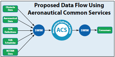
SWIMming to a Solution
The second option is developing a new software system called the Aeronautical Common Service, or ACS. As the graphic above illustrates, it will collect and combine information from the five sources shown, focusing on SUA. This information consists of airspace defining the SUA and the schedules as published. ACS will provide SUA information to consumer systems through something called SWIM by the time you read this.
SWIM’s purpose is simply to provide System-Wide Information Management. As the data-sharing backbone of NextGen, SWIM manages information to assure that all users see the same information. This dual consistency helps everyone make better decisions using all information available, including, of course, SUA.
SWIM is a cloud-based single point of access to real-time, relevant, and dependable airspace, flight, weather, and surveillance (radar and ADS-B Out) information. Importantly, SWIM is the information access gateway for the aviation community, which vendors use to bring products our way. SWIM is a natural way to meet the government mandate.
The missing piece is how this information gets into the cockpit, concerning which the FAA is oddly silent. It could be uplinked to cockpits via Sirius XM as it displays TFRs today. But pilots lacking XM will be left out in the cold, and there are surely more ADS-B In than XM users. The FIS-B approach seems fairer and more equitable.
The FAA’s mission is to provide a safe, efficient airspace system. Designers know they must facilitate data transfer from the DoD to the FAA to NAS users. It must be confirmed to be safe and correct before it goes live. The FAA extends itself to subtle, even extreme, lengths to protect NAS users down to the smallest detail. Attaining that level of data precision takes time. As an interim step, the team is working to push the corrected schedule directly to the cockpit, as noted earlier.
The FAA faces the persistent challenge to weigh the needs and requests of all users to find the right balance. The FAA engages with avionics vendors through RTCA because they know our needs well as suppliers to the pilot community.
Today’s To-dos
Since 2012 the FAA and DoD have greatly improved how their systems communicate. These enhancements enable higher fidelity of scheduled SUA information on sua.faa.gov. We are encouraged to use this site to aid efficient flight planning. Many Victor airways parallel SUA, which allow us to skate close but not intrude. Controllers also like it because it minimizes reroute and vectoring workload.
Feel free to plan your flight through SUA if you expect to exit it before it goes hot. If you enter inactive SUA close to the time it’s expected to go live, ATC will coordinate and let you exit first. ATC may request an altitude change to assist the using agency. Conversely, if the SUA goes active a little earlier, you might get rerouted. ATC will never knowingly “drive” you into an airspace violation.
Always contact ATC for the status of imminent SUAs. ATC can use vectors and point-to-point routings to help you maintain separation. You are entitled to a reason for either, but if not offered, ask. They can also issue traffic advisories relative to participating aircraft.
Aircraft sometimes receive IFR clearances through SUA. If so, ask for permission through it. ATC will call the using agency and coordinate your transition if possible. Said one controller, “It’s a tool controllers don’t utilize as much as they could.”
The FAA repeatedly emphasizes using sua.faa.gov and the current importance of contacting ATC for the latest word on SUA status. Improvements are on the way.


