
It’s been a pretty smooth flight so far, but out of the haze, you see the emerging outline of a huge towering cumulus. Oh, wonderful—an afternoon thunderstorm in your way.
As the billowy texture fills out, the controller working you chimes in. “November Six Alpha Bravo,” he tells you, “area of moderate precipitation, twelve o’clock, ten miles, approximately eight miles in diameter, moving northeast.”
The controller is providing you weather information, which you—as Pilot in Command—factor into your decision-making. We controllers know it’s your butt on the line, not ours, and we can’t fly the plane for you. All we can do is tell you what we see. Once you decide a course of action, such as a deviation left or right, we’ll try to work it out for you.
That begs the question, though: how is this weather being displayed for the controller? What is its source, and how much faith can you place in its accuracy?
Limited Palette
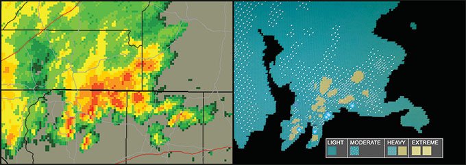
You’re accustomed to seeing brilliant multi-color weather radar returns with deep reds, brilliant yellows, rich purples and blues. Those hues make the intensity of a storm system very clear.
But controllers are primarily concerned with directing aircraft, so a dynamic rainbow of colors on their scope would be a serious distraction. For that reason, ATC radar scopes show at most six levels of weather intensity in muted blue and green colors that won’t swallow up their white traffic targets.
ATC radars also only register precipitation. Other factors like cloud coverage, lightning or wind aren’t depicted. It could be a solid overcast and our scopes will be clean without precip. That means we also don’t see storms until their mature stage when rain, snow, or hail is present. We also have no idea how far out invisible factors like turbulence or downdrafts extend from the core.
Source Material
Terminal Radar Approach Controls (TRACONs) and Air Route Traffic Control Centers are both ATC radar facilities that display precipitation on the radar scopes. However, that’s largely where the weather similarities end. Each facility type receives its weather data via entirely different methods.
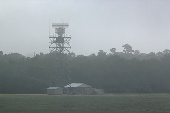
TRACONs use short-range air surveillance radars such as Raytheon’s digital ASR-11 as well as Northrop-Grumman’s older analog ASR-9 and upcoming digital ASR-12. These units have two processor channels, one for aircraft and one for weather, and their displayed range varies from 60-100 n.m. depending on model.
The weather channels process precipitation in all six levels of intensity, updated instantly every time the radar dish rotates, approximately six seconds. Level one is light precip, level two is moderate, three and four are heavy, and five and six are extreme. These levels are displayed on the controller’s scope in green or blue.
Centers use long range radars with ranges out to 200 n.m. At those ranges, only the most severe precip would be detected. So, their weather data actually comes from the national network of 159 overlapping NEXRAD Doppler radar stations—the same stations used by the National Weather Service, Wunderground, and other weather providers.

NEXRAD reaches the controllers’ scopes via a system called the Weather and Radar Processor. WARP takes the NEXRAD data, filters it, and flattens it down to only three precipitation levels: moderate, heavy, and extreme. Light precip is not shown. This weather is layered underneath the traffic targets generated by the long range radar.
Each Center staffs a Center Weather Service Unit (CWSU). This dedicated crew of NOAA meteorologists provides current weather data and forecast products for controllers, dispatchers, and pilots. They create and disseminate SIGMETs, Convective SIGMETs, AIRMETs, and Center Weather Advisories.
Scope Lagged
What’s the difference for you, the pilot, between TRACON ASR and Center WARP? In a word, freshness.
When a TRACON controller issues a weather report—”Area of moderate precipitation, twelve o’clock, eight miles, approximately ten miles in diameter, moving northeast.”—they are looking at live radar returns, updated approximately every six seconds. If he suggests a heading or a direction to deviate, he’s basing it off current data.
Control towers with radar displays usually get their precipitation data fed from the same radar system their overlying TRACON uses. This also ensures accuracy when you’re deciding whether to request a specific heading to dodge a storm cell, depart from a different runway, or wait things out on the ground.
Center WARP weather instead relies on those periodic NEXRAD updates. The next time you watch a NEXRAD weather radar loop, check the timestamp for each frame of the animation. A minimum of four or five minutes passes between each frame. It’s similar to the lag time on in-flight systems that get their weather data via satellite.
For a practical application, let’s go back to our original scenario: the thunderstorm building off your nose. If that was a TRACON controller describing the weather to you, he’s looking at the real-time situation.
But a center controller is looking at data potentially over five minutes old. In rapidly developing weather, that’s a huge window. Moderate precipitation could become extreme during the lag.
This can be a big problem if you’re shooting the gap between cells. The gap could shut in a few minutes. The freshest data available would help you choose between that gap or just going around.
Center controllers I know are frustrated by the time delay, as it sometimes hinders their ability to provide service. NEXRAD is accurate and is excellent for rerouting traffic around large areas of weather, but many of the finer details—like shooting the gap—become riskier.
Knowing the kind of weather information that’s being provided can help you make informed, safer decisions.
Editing Reality
Since radars only depict wet stuff, what about other factors like ceilings, visibility, temperature, dew point, and wind?
ATC gets that kind of information the same way pilots do—METARs and relevant SPECIs generated by a network of automated weather stations around the country, the newer model of which is called the Automated Surface Observation System (ASOS). These sensor arrays constantly collect and process weather conditions. TRACONs and Center controllers have easy access to weather reports from stations in their airspace.
Now, weather’s literally a fluid thing, and even the fanciest ASOS can miss the nuances. When an ASOS is located on a towered airport property, the control tower often has direct access to its output. Tower controllers are constantly monitoring the automated sensors and verifying if the ASOS data matches the world outside their cab windows.
Controllers with this responsibility are certified weather observers via the FAA’s Limited Aviation Weather Reporting Station program. This gives us the power to manually edit the ASOS info before it gets transmitted as a METAR or SPECI.
We essentially “trust but verify.” For instance, the ceilometer on our airport ASOS that measures cloud ceilings has a narrow horizontal range. The ceiling could be 1000 feet broken, but if there just happens to be a gap in the clouds directly above it, it’ll report clear skies
The visibility sensors are equally twitchy. It could be a beautiful VFR morning, but one patch of ground fog over the sensor could yield “VISIBILITY 1/4 MILE” and indefinite ceilings. When the ASOS data isn’t matching reality, our tower controllers will edit the output data before it winds up in anyone else’s hands.
One thing to note when a controller issues you precipitation: the precip we’re describing may be above or below you. Nature is three dimensional, but our scopes only show two.
In the afternoon thunderstorm example, say you’re at five thousand feet. ATC describes the precipitation. You can clearly see the storm off your nose. What if the controller reports the same precip to an airliner at 35,000 feet? That pilot may reply, “Uh… it’s clear up here.” He’s simply above the storm. We just don’t know its vertical scale, so we have to call it anyway to be safe.
Don’t Keep Secrets
So, the weather sensor’s output can’t always be relied upon. Center weather data is laggy. How does ATC confirm what’s really out there if they can’t determine it on their own?
That’s where you come in. An accurate firsthand pilot report can outrank automated weather recording equipment any day of the week. We’re inside a building and our sensors are also located on the ground. You’re actually up there in the soup, experiencing things firsthand.
If our ASOS is saying the ceiling is broken at 1500 feet, and you tell us you broke out at 1100, don’t be surprised to hear “CEILING ELEVEN HUNDRED BROKEN” on the subsequent ATIS broadcast and read “BKN011” on the latest METAR. Your input really matters.
Controllers are actually required to solicit PIREPs under certain conditions. When the weather drops below a five thousand foot ceiling or five miles of visibility, controllers are supposed to request them every hour. PIREPs are also required when hazardous phenomena such as wind shear, thunderstorms, and icing exist in the area.
In a tower and TRACON environment, we’ll typically solicit cloud bases, cloud tops (useful for VFR-on-Top requests), and how the ride is on final. Critical pilot reports are passed between the cab and the radar guys via ATC’s internal landlines. If a pilot reports breaking out right at minimums for our ILS approach and she experienced moderate turbulence the whole way down, the tower will pass that on so radar can warn the next aircraft in the approach sequence to prevent surprises.
Centers will solicit much of the same low-altitude data the terminal facilities do, but they’ll also contend with high-altitude weather affecting their cruising traffic. When hazardous conditions like icing and turbulence are present, the frequencies can come alive with icing type and severity descriptions and ride reports. Their controllers will be passing that information amongst themselves and on to the pilots in the area.
As the Flight Service briefers say, PIREPs are always welcome. Even if ATC doesn’t solicit a PIREP from you directly, it’s a good practice to pass on what you encountered anyway, especially if it differs from your expectations. Icing is a particularly good example of this. Your plane may have the latest in deicing boots and heaters. The guy right behind you may not. Let ATC or Flight Watch know so they can pass on the word.
ATC’s weather service is only as good as the information controllers have on hand. Don’t be shy about letting ATC know about things other pilots may find significant. You can truly help other pilots arrive safely and allow ATC to verify just what exactly is going on out there in that big sky.
Tarrance Kramer does his best to help pilots understand the weather he sees when working traffic as a controller somewhere in the South.


