
The FAA’s Advisory Circular 90-108 just feels wrong. In it, section 8 itemizes circumstances where a “suitable RNAV system” (including GPS and GPS/WAAS equipment) cannot be used.
One prohibition is substitution on a final approach segment, FAS. We know this rule well and compliance is easy. Before reaching the FAS, most often denoted by an FAF, change the CDI source button from GPS to, as the AC says, “the NAVAID (for example, a VOR or NDB) providing lateral guidance for the final approach segment.”
Easy to do, but the logic is hard to fathom. How is safety enhanced by flying an 80-year-old and famously imprecise NDB when GPS is at your fingertips? AC 90-108 was issued in early 2011, seventeen years after FAA incorporated GPS into the National Airspace System. More than 190,000 GA aircraft, some 80 percent of the U.S. fleet, use GPS as their primary means of navigation. Moreover, GPS is aboard almost 80 percent of air carrier fleets, almost all military planes and most foreign aircraft entering U.S. airspace. So why this painful conservatism?
The next prohibition is readily understood, equally conservative, but leaves us scratching our heads as to how to comply:
Paragraph 8.c. of the AC prohibits RNAV use for “Lateral navigation on LOC-based courses (including LOC back-course guidance) without reference to raw LOC data.”
Note the difference in these two paragraphs. The first refers only to the final approach segment, but the second refers simply to LOC-based courses. Perhaps you want to use RNAV to intercept the final approach course well outside the FAF. You can do that for all but LOC-based courses (LOC, BC and ILS). For those localizer courses, you must refer to the raw localizer data. Paradoxically, this proves easy for round-dial panels but nearly impossible for GA’s integrated systems.
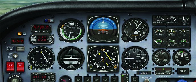
Bravo for the Mooney
To illustrate, let’s start with your Mooney Bravo. You have a conventional HSI as shown and a neat little toggle switch on the far left that selects whether the HSI will be driven by GPS or a nav source, usually nav 1.
In this scenario, your Mooney is flying heading 120 to join an ILS localizer whose bearing is 089 degrees. Fine, that’s a standard intercept and the switch setting shows that the HSI is GPS-driven. This alone is not legal, but the separate VOR indicator tuned to the localizer constitutes raw data and hence fully complies with the stricture in AC-108 8.c. It’s all good.
Except that nav 1 is now useless with no display until we have to switch to localizer nav on the HSI just before the FAF. This seems like a waste of resources, but more pragmatically makes it difficult to verify fixes along the approach such as an intermediate fix or the FAF unless you flip-flop nav 2 or wait until you’re using nav 1.
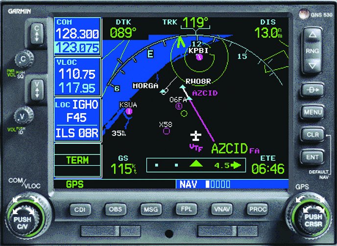
Otherwise you would have to rely on the GPS display shown. It clearly depicts AZCID, the FAF, but as you can see here, in many systems once vectors-to-final has been activated, all fixes but the FAF disappear.
Adding to the unpleasantness, notice that the glideslope needles along the sides of the HSI are blank, because the GPS can’t provide a glideslope for the ILS. About two nm from the FAF, you will have to switch to the ILS receiver in your GPS by selecting LOC mode, a function that is automatic in many GPS receivers including the GNS 530 shown here.
Since we assume here that you have a separate GPS, you could fly the GPS left-right needle on its screen while the HSI tracks the localizer. This too would be perfectly legal. It would have the additional advantage of freeing nav 2 to identify intersections.
However awkwardly, you have met the stricture of AC 90-108. Congratulations.
EFIS
Electronic Flight Information Systems like the Aspen EFD 1000, the Garmin G1000 and the Avidyne Entegra Release 9 all have the same problem, which is that there is no way to show raw ILS information on the HSI when the primary nav source is GPS. Nope, it just can’t be done.
None of them show multiple HSIs, which would be very confusing anyway. If the primary nav source is GPS, all of these systems can show two additional nav displays in the form of single and double-barreled bearing indicators, making it possible to show three nav sources at once. The bearing pointers qualify as raw data if pointed at a nav system offering bearing information, like a VOR or even an NDB.
However the raw data problem is not solved because none of these systems can show a localizer as a bearing pointer. This is not the vendors’ fault, but rather an attribute of how the localizer signal is constructed. The ILS localizer contains no bearing information as does a VOR signal. The left side of the localizer is simply modulated by a 90 Hz tone and the right side at 150 Hz. These tell you how far off you are left and right, but the bearing information is buried in the fact that the localizer beam is focused in a certain direction, here 089 degrees.
Workaround
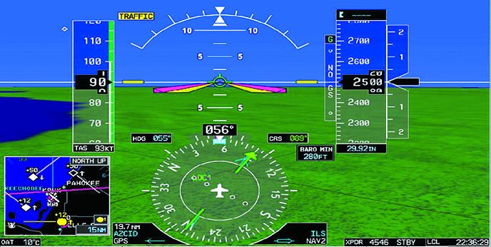
Since the HSI is the only raw-data source, it must be set to the localizer. Of course, you could configure a bearing pointer to aim at the FAF.
In the G1000, the bearing pointer will be aimed at the FAF automatically if the approach is active. You can see that on the lower left side of the G1000 HSI and the single needle pointing at AZCID. This does not qualify as raw data because the location of AZCID is GPS-derived. Because bearing pointer 2 is set to an ILS frequency, no pointer is shown. This behavior is common. If the source is invalid, no pointer is shown, just as the deviation bar (the D-bar) on an HSI would be absent for the same reason. In this case, we are 25 nm from the localizer which explains why there is no D-bar because the localizer is only valid out to 18 nm (AIM 1-1-9 b. 5.). By these principles, you cannot be misled by a faulty, weak or absent signal source.
Legal as this is, it results in a faint GPS display because the bearing needle is much less visible than the very clear HSI. For this reason some pilots use the double-bar needle instead.
Splitting Hairs
One other solution suggested by our editor, who’s always searching for loopholes, relies on a close examination of the wording of the AC. That paragraph 8.c prohibits lateral navigation on a localizer without raw data. This leaves a little wiggle room for you to intercept using GPS, but once turning onto final, you must switch to the localizer for lateral navigation on that course. This is splitting hairs and you’ll have to decide the legality for yourself.
In Sum
It would be nice if we could spell out a neat solution that addresses the AC completely and conveniently. As here, sometimes it doesn’t work out that way. Then we point out the issues and mitigate them as best we are able.
Given the difficulties involved, it’s reasonable to ask, “Why bother with the GPS at all on a localizer approach?” After all, the localizer signal is good to 18 miles from the source. Similarly, the glideslope is valid out to ten miles. It’s hard to imagine being vectored to final from more than 18 nm away. And if you are, you have no choice but to use the GPS until you come into range of the localizer. Hey, this is how it works in the real world: Fight bureaucracy with bureaucracy.
Fred Simonds is an anti-bureaucracy but not anti-authority CFII who works in Florida. See his web page at www.fredonflying.com.


